.jpg)
Mount Cuthbert Township and Smelter
A thousand people lived here once, in a valley you can now drive through and barely notice. Between 1915 and 1925, the township of Mount Cuthbert burned bright and brief in the ranges north-west of Cloncurry, a copper-smelting town that materialised almost overnight and vanished almost as fast. Today three steel chimneys still stand above the Six Mile Creek, rising from a vast black slag dump, and around them lie the stone footings of some sixty buildings: a town's worth of fireplaces and floor slabs marking where homes, hotels, and stores once stood in country that has belonged far longer to the Kalkadoon people than to any miner.
Copper in Kalkadoon Country
Copper was noticed here early. The explorer Ernest Henry came across it near Mount Cuthbert in 1867, though nothing was made of the find for decades. This was the country of the Kalkadoon, whose name the richest mine and a railway siding would later carry, and whose people had defended these ranges fiercely as pastoralists pushed into the district from the 1860s in skirmishes that cost many Aboriginal lives. By 1900 Melbourne investors had sent geologists to test the claims, and Mount Cuthbert assayed best of all at 6.5 per cent. What finally unlocked the field was a government decision to push the Great Northern railway inland, which made it conceivable to haul heavy ore out of country this remote.
A Town That Appeared Overnight
When copper prices soared during the First World War, Mount Cuthbert exploded into being. The mining company built smelters, sank shafts, and strung electricity to its surface buildings, and a town assembled itself around the works almost faster than it could be surveyed. At its 1918 peak Mount Cuthbert held a thousand people, with two hotels, a cordial factory, stores and fruiterers, a photographer, a hospital, a police station, and two railway stations. The contrast inside the town was stark. Company officers lived in timber cottages, while most residents made do in tents and corrugated-iron shacks with earth floors and stone hearths. A school opened in 1917 for thirty children, and that same year, when the railway freight faltered, the whole town was briefly reported to be on the verge of starvation.
Sixty-Three Days and Done
The smelter was the work of William Henry Corbould, a metallurgist whose blast-furnace design here was unlike any other in North Queensland. Fired early in 1917, it treated tens of thousands of long tons of ore and sent prime blister copper to Britain. But a wartime boom is a treacherous thing to build a town on. When the crankshaft snapped on the blower engine in 1918, the furnaces went cold for nearly a year. When copper prices finally collapsed, the end came quickly: the smelters shut for good on 19 June 1920, after a last run of just sixty-three days. Liquidation followed in 1923, and when the Mount Elliott Company bought the property in 1925, Mount Cuthbert became a ghost town. The population had fallen from a thousand to nothing in seven years.
The Most Beautiful Ruin in the North
Heritage assessors do not often reach for the word beautiful, but Mount Cuthbert earns it. Listed on the Queensland Heritage Register in 2004, it is judged the largest and most impressive early smelter ruin in North Queensland, made more haunting by its setting in the picturesque Six Mile Creek valley. The approach is part of the spell: the old railway curves through cuttings in the range before the three chimneys and the great slag dump suddenly open into view, exactly as they did for arriving miners a century ago. Two copper converters, iron flues, and the steel skeleton of the blast furnace still stand. Even the hotel survives in a sense, reputedly carted to nearby Kajabbi, where it pours beer to this day as the Kalkadoon Hotel.
From the Air
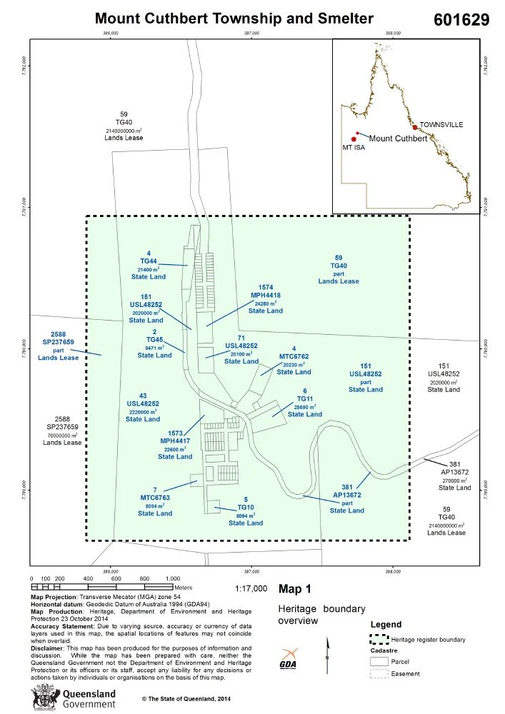
Mount Cuthbert lies in the ranges north-west of Cloncurry at about 19.99 degrees south, 139.92 degrees east, strung along the Six Mile Creek valley north-west of Kajabbi. From the air the site is unmistakable: three standing chimneys and a large dark slag dump on the valley floor, with the curving scar of the old railway formation threading the surrounding ridges. The township footings spread across a low rise just east of the smelter. There are no nearby airfields of significance; this is genuinely remote country, with Cloncurry Airport (ICAO YCCY) the nearest substantial field to the south-east and Mount Isa Airport (YBMA) to the south-west. Terrain is rugged and broken, so the creek line and rail alignment are the best navigational handrails. Dry-season air gives the clearest view; recommended viewing altitude 2,000 to 4,000 feet AGL to read the smelter and township against the valley.
Nearby Stories
- Quamby 17 km away
- Lake Moondarra 45 km away
- Ernest Henry Mine 72 km away
- Riversleigh World Heritage Area 95 km away
- Camooweal Caves National Park 108 km away
- Augustus Downs Station 127 km away
- Moonah Creek Hanging Tree 147 km away
- Burke and Wills Camp B/CXIX 210 km away