.jpg)
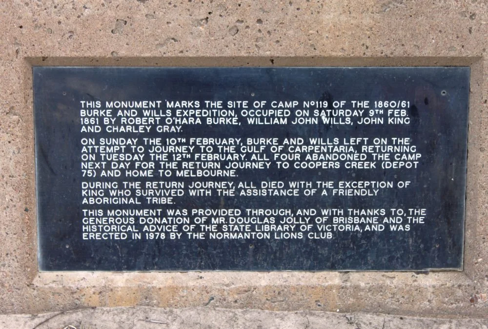
Burke and Wills Camp B/CXIX
They came so close. In February 1861, after fifty-seven days of forced marching up the centre of the continent, Robert O'Hara Burke and William John Wills stood in a tangle of mangroves near the Gulf of Carpentaria and could go no further. The salt smell of the sea was almost certainly in the air. But the mangroves and tidal mud blocked the way, and after three days of struggle they never actually saw the open water they had crossed Australia to reach. Then they turned south, back toward Cooper Creek and, though they could not know it, toward their own deaths. The dusty, unremarkable patch of ground they left behind, Camp B/CXIX, became the most northerly marked campsite of the expedition, and one of the most poignant places in Australian exploration.
The Society's Grand Idea
The expedition was born in the parlours of Melbourne. In 1857 the Royal Society of Victoria, an organisation drawn from the colony's wealthiest and most learned men, resolved to fund a crossing of the continent from south to north and raised the money largely by public subscription. To lead it they chose Robert O'Hara Burke, a police superintendent born in County Galway in 1821, a man of restless courage but little bush experience, who had pursued the post anxiously. As surveyor and astronomer they appointed William John Wills, born in Devon in 1834 and trained in medicine, a careful and methodical young man who would become Burke's loyal second. The instructions were vague, the rivalry urgent: a South Australian party under John McDouall Stuart was racing for the same prize, the honour of being first across the centre.
The Dash to the Gulf
Burke was a man in a hurry, and haste undid him. He pushed ahead of his supplies, left men strung out behind at Menindee, and at Cooper Creek made a fateful decision: to strike for the Gulf at once, before the wet season closed in, with just three companions. The small party, Burke and Wills with John King tending the camels and Charles Gray as camp organiser, followed a line northeast of Stuart's intended track and reached the Little Bynoe River, west of the Norman River, on 11 February 1861. They were thirteen days behind schedule and running low on food. When the mangroves stopped them short of the coast, Burke and Wills left Gray and King at the camp and pushed on alone, returning three days later having tasted the failure of arriving so near and not quite reaching the goal.
Marks on the Trees
What the explorers left behind was almost nothing, and that is what makes the site so moving. Early Australian explorers marked their passage by blazing trees, cutting away a patch of bark and carving into the wood beneath: their initials, a date, a number recording the progress of the journey. The cipher B/CXIX meant Burke's 119th camp. During their three days here the party blazed fifteen Coolibah and Gutta-percha trees, scars that could later be matched against the precise entries in their journals to prove, decades on, exactly where they had stood. These quiet cuts in living wood are now rare and precious things, surviving alongside the famous "Dig Tree" at Cooper Creek as some of the only tangible evidence of the whole tragic enterprise.
The Long Walk Back
The return journey was a slow catastrophe. Charles Gray weakened steadily, suffering pain in his head and limbs, and died on the morning of 17 April 1861. When the surviving three finally staggered back into Cooper Creek, they arrived only hours after the support party, having waited four months, had given up and departed. Burke and Wills both died along the creek in late June. John King alone survived, kept alive by local Aboriginal people who shared their food and shelter with the starving stranger until Alfred Howitt's search party found him in September. Months later another searcher, Frederick Walker, hunting for the lost men, camped near this very site and blazed his own tree three-quarters of a mile away. The blazed trees stood undiscovered for nearly half a century until station staff stumbled on them in 1909. Ten survive today, fenced and marked on a dusty plain that betrays no hint of the desperate drama it once held.
From the Air
Camp B/CXIX lies at roughly 17.88°S, 140.83°E, about 35 km south-west of Normanton in the Gulf Country of far-north Queensland, close to the Little Bynoe River and a couple of kilometres south of the Normanton–Burketown Road. From the air this is flat, low-lying Gulf savannah laced with the braided channels and seasonal overflows of the Bynoe and Norman river systems, with the great expanse of the Gulf of Carpentaria and its coastal mangrove belt to the north. The site itself is tiny and unmarked from altitude; navigate instead by the river channels and the town of Normanton to the north-east. The nearest airfield is Normanton (YNTN); Burketown (YBKT) lies to the west and Karumba (YKMB), on the Gulf coast, to the north. In the dry season (roughly May to October) the plains are firm and visibility excellent; the summer wet transforms this entire low country into a vast sheet of floodwater, exactly the impassable, mangrove-choked terrain that turned the explorers back, with frequent storms and poor visibility.
Nearby Stories
- Karumba 11 km away
- 2000 Australia Beechcraft King Air Crash 24 km away
- Normanton to Croydon Railway Line 36 km away
- Leichhardt River 58 km away
- Nicholson River 71 km away
- Golden Gate: The Richest Reef on the Field, Now a Field Again 92 km away
- Leichhardt Falls 99 km away
- Aboriginal Shire of Kowanyama 238 km away