Muchinga Province
On September 30, 2011, Zambia's president Michael Sata signed the order that turned part of Northern Province into a new tenth province called Muchinga. The announcement surprised almost no one, since Sata had campaigned on the promise. The name had been floating around in political conversation for years. Muchinga was the last thing Northern Province had left to offer: the escarpment that gave the region its name, a long ridge running southwest to northeast where the land plunges down into the Luangwa Valley. The new province got that escarpment, the Great North Road, and most of the TAZARA Railway corridor. It got eight districts. It got 711,657 people, counted on the 2010 census just months before their map changed under their feet.
A Province Written Along Two Roads
Almost every significant town in Muchinga sits on the Tanzam Highway, also known as the T2 or the Great North Road. The highway runs from Lusaka up through Kapiri Mposhi and enters the province from the southwest, rolls through Mpika and Isoka, and crosses into Tanzania at Nakonde. From Mpika, a second major artery, the M1, branches north toward Kasama and Lake Tanganyika. The TAZARA Railway traces roughly the same path, a Chinese-built project from the 1970s designed to give Zambia a way to export copper without crossing apartheid-era Rhodesia or South Africa. Muchinga is the province the railway built, in the sense that its economic geography is organized along tracks and asphalt running to the sea 1,800 kilometers away.
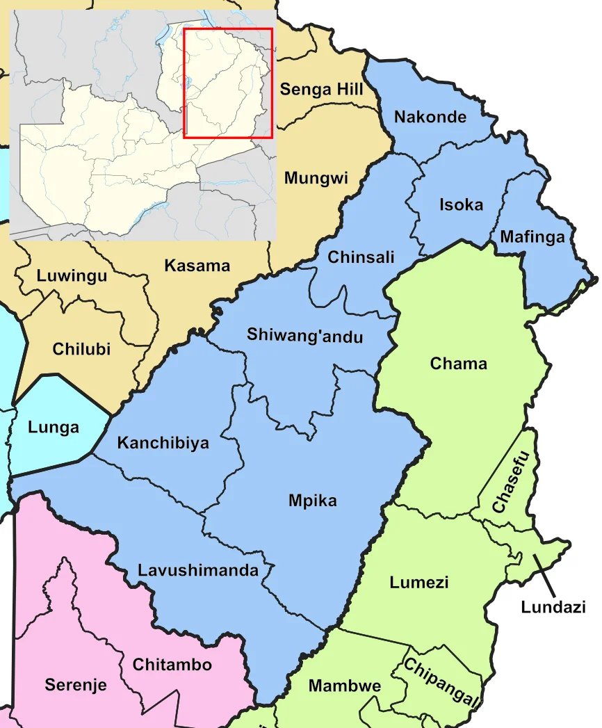
Eight Districts and a Rural Reality
The province has eight districts: Chinsali, Isoka, Mafinga, Mpika, Nakonde, Shiwang'andu, Kanchibiya, and Lavushimanda. Seven of them share names with their district headquarters; Mafinga is the exception. There are no cities here, and no municipal councils. The province is 83 percent rural. Population density sits at 8.1 people per square kilometer, a number that tells you the land is mostly bush, miombo woodland, and scattered farms. Each district has a council of 63 mandated responsibilities, from road maintenance to running libraries and cemeteries. Councilors serve three-year terms without salary, drawing allowances instead. The administration is the kind of thin provincial structure you build when the priority is getting any government presence at all into a very large, very sparse territory.
The Numbers Behind Everyday Life
The 2010 census captured a province that was growing faster than Zambia as a whole. The total fertility rate was 7.0 children per woman. Household size averaged 5.1. Median age at marriage was 20. Life expectancy at birth, at 53 years, was two above the national average. Bemba is the language most people speak at home, 47 percent of the province, which makes sense given that Muchinga was historically the Bemba heartland before colonial borders were drawn. The literacy rate of 63.5 percent sits below the national average of 70.2 percent, one of the costs of rural distance from schools. Unemployment was 6.4 percent, low by any measure, though most employment here is subsistence agriculture. The province counted 1,634 people living with albinism, a figure Zambian health authorities track because people with albinism in parts of Central and Southern Africa have faced persecution and violence tied to ritual beliefs.
Mpika at the Crossroads
If Muchinga has a center, it is Mpika. The town sits where the M1 branches off from the Great North Road, where the TAZARA Railway runs parallel to the highway, and where the old colonial north-south spine crosses the new lateral routes toward Lake Tanganyika. Chinsali, the provincial capital, draws the administrators. Nakonde draws the cross-border traders. Mpika draws the trucks and the trains, and with them the small commerce that attaches itself to a transportation hub. The Muchinga Escarpment rises east of here, a 500-meter drop into the Luangwa Valley where elephants and lions still live on a continental scale. North Luangwa National Park and South Luangwa National Park lie just over the edge, in the old Eastern Province, but Muchinga commands the high ground above them.
A Political Creation, Not a Natural One
Muchinga was not carved from geography. It was carved from politics. Michael Sata's Patriotic Front won votes in the northeast partly by promising this province, and once in power delivered on the promise. Critics argued at the time that new provinces and districts were more about patronage than efficiency, that they multiplied salaries and offices without multiplying services. Defenders argued that smaller administrative units meant closer government, better data, more accountable councilors. Both were right. Fifteen years in, Muchinga has its own identity now, its own ministers, its own provincial sports teams. The escarpment that gave it the name has not moved, and neither have most of the people whose lives were re-labeled in 2011.
From the Air
Muchinga Province centers near 10°S, 32°E in northeastern Zambia. Elevation mostly 1,200-1,600 meters with the Muchinga Escarpment marking a dramatic drop east into the Luangwa Valley. Recommended viewing altitude 8,000-12,000 feet MSL to appreciate the escarpment's relief. The TAZARA Railway and Great North Road (T2) run southwest-to-northeast through the province. Nearest airports: Kasama (FLKS) to the west, Mfuwe (FLMF) southeast in Luangwa. Visual landmarks: Muchinga Escarpment, Bangweulu Wetlands to the west. Weather note: single wet season November-April produces heavy afternoon thunderstorms; dry season (May-October) offers excellent visibility. Smoke from managed burning is common August-October.
Nearby Stories
- TAZARA Railway 40 km away
- Mwela Rock Paintings 45 km away
- Chitipa District 69 km away
- Chambeshi River 73 km away
- Ntawere Formation 81 km away
- Songwe Region 102 km away
- Shiwa Ngandu 121 km away
- Mbala District 125 km away