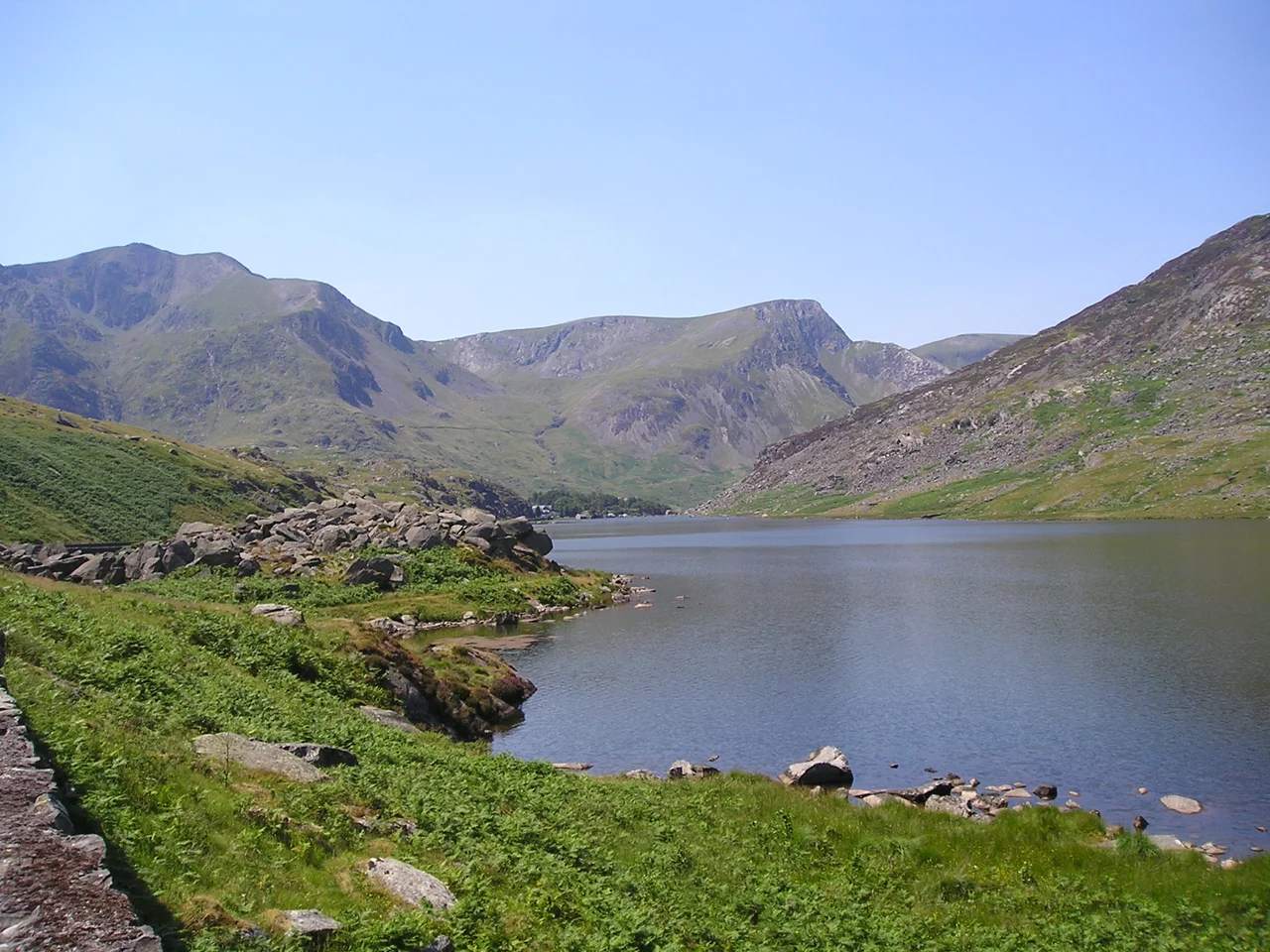

Nant Ffrancon Pass
Geography teachers love Nant Ffrancon. It is the kind of glacial valley that turns up in every undergraduate textbook chapter on the work of ice: the broad U-shaped cross-section, the truncated spurs along its sides, the hanging valley of Cwm Idwal spilling its meltwater off the southern wall in the Ogwen Falls. Most U-shaped valleys in Britain are middling examples or compromised by farmland. Nant Ffrancon is the real thing. From the air, dropping in toward the A5 from the east, you see the floor of the valley laid flat between two great mountain walls - the Glyderau to the south, the Carneddau to the north - and the road following exactly where ice once flowed.
What the Ice Did
About 18,000 years ago, the last great ice sheet flowed down what we now call Nant Ffrancon, gouging a deep trough between the rising Glyderau and Carneddau ranges. As it moved, it widened the original V-shaped river valley into a U; truncated the lower ends of side ridges into the abrupt cliffs visible today; and oversteepened the walls of the cwms it left along the way. The pass itself reaches 312 metres at Pont Wern-gof, a third of a mile beyond the eastern end of Llyn Ogwen. From there the valley descends steadily north-west to Bethesda, where slate quarrying ate into the Carneddau through the eighteenth and nineteenth centuries. The cirque of Cwm Idwal, perched above the valley floor on the southern side, drained into the Ogwen by a stream that drops into the main valley as the Ogwen Falls. It is the kind of landscape that exists almost entirely because of erosion, with the mountains as the leftovers.
Lord Penrhyn's Road
Until the late eighteenth century, getting through Nant Ffrancon was awkward. The valley floor was boggy; the only routes were rough tracks for drovers and pack horses. Richard Pennant, 1st Baron Penrhyn - the local slate baron, owner of the great Penrhyn Quarry on the northern side of the pass - built the first proper road through the valley in the late 1700s. His road largely followed the valley floor, where the ground was easy but tended to flood. At the eastern end of the pass, in 1801, Penrhyn also built a coaching inn at Capel Curig. That inn is now Plas y Brenin, the United Kingdom's National Mountaineering Centre, where generations of climbers and instructors have learned their trade. The original road served its purpose, but it was not robust enough for the heavier traffic the nineteenth century was about to bring.
Thomas Telford and the Mail Coaches
Between 1810 and 1826, Thomas Telford re-engineered the route through Nant Ffrancon as part of the London-to-Holyhead trunk road - now the A5. The brief was political: faster, safer mail coaches between London and the Irish-bound ferries at Holyhead, after the Acts of Union folded Ireland into the United Kingdom in 1801. Telford abandoned Penrhyn's valley-floor alignment and carved his new road into the north-eastern flank of the Nant Ffrancon, blasting it out of solid rock in places. The construction was difficult and the maintenance has been demanding ever since. But the benefit was decisive: Telford managed to hold the gradient to a maximum of 1 in 14 along the entire 260 miles from London to Holyhead. That allowed horse-drawn mail coaches to maintain steady speeds without exhausting their teams - a piece of mass-transport engineering that fundamentally changed the time it took to get a letter from London to Dublin. The road he built is still in service today, somewhat re-aligned but recognisably his.
The Khyber Pass and the Himalayas
The valley's dramatic, treeless, almost lunar profile has made it a recurring stand-in for other places in British cinema. The 1968 Carry On film Carry On up the Khyber used Nant Ffrancon as the Khyber Pass between India and Afghanistan - and the joke that the British army made a generation of West End cinema-goers believe Snowdonia was Central Asia worked because the valley really does have that scale and that absence of trees. The classic Doctor Who serial The Abominable Snowmen (1967) shot Nant Ffrancon doubling for the Himalayas; the production team needed somewhere bleak enough to suggest the world's highest mountains, and the valley delivered. The 1958 film The Inn of the Sixth Happiness, starring Ingrid Bergman, used the same valley as a backdrop for its supposed China. None of these films pretend very hard. North Wales is what is on screen.
From the Air
From the air, dropping in west of Capel Curig in summer evening light, the textbook qualities of the valley are unmistakable. The flat floor where ice once flowed. The smooth U-shaped walls climbing on either side. The hanging cwm of Idwal cut into the southern wall with the dark band of Llyn Idwal visible at its centre. The A5 threading along the north-eastern flank where Telford carved it. The white scar of the Penrhyn Quarry running off the Carneddau side at Bethesda. A defunct Nant Ffrancon Golf Club appeared briefly in the late 1920s and was wound up in 1936; it is a small footnote in a valley whose main story is much, much older. Ten thousand years of slow recovery from ice; 200 years of slate and road-building; a few weeks each of pretending to be the Khyber Pass and the Himalayas. The shape underneath everything is the shape ice leaves when it goes.
From the Air
Located at 53.15°N, 4.04°W. The pass runs roughly south-east to north-west between Llyn Ogwen and Bethesda, length about 5 nm. Summit elevation 312 m at Pont Wern-gof. The valley floor is broad and flat at 200-250 m, the walls climb to 800-900 m within 1 km on either side. Best viewed from 2,500-4,000 ft AGL on tracks parallel to the valley. The A5 follows the north-eastern flank. Llyn Idwal hangs in Cwm Idwal on the southern side. Nearest airports: EGCK (Caernarfon Airport) 12 nm WSW, EGOV (RAF Valley) 24 nm WNW. Expect severe rotor turbulence in any westerly or south-westerly flow as wind tumbles off the Glyderau into the valley.
Nearby Stories
- Tudweiliog 3.6 km away
- Denbigh Castle and Town Walls 6.4 km away
- Rhoscolyn Lifeboat Station 7.6 km away
- Butlin's Pwllheli 20 km away
- East–West Interconnector 20 km away
- New Brighton Lifeboat Station 31 km away
- Battle of Oswestry 31 km away
- Celtic Array 44 km away