New Don Pedro Dam
Don Pedro was not Spanish. Pierre Sainsevain was a Frenchman who prospected along the Tuolumne River during the Gold Rush, and the mining camp that grew around his claim adopted the name his neighbors gave him: Don Pedro. The original dam bearing that name, completed in 1923, stood 284 feet tall and briefly held the title of highest dam in the world. By the 1940s, farmers in the San Joaquin Valley realized it could only store about one year's water supply, offering no insurance against the multi-year droughts that California delivers with grim regularity. The solution was not to expand the old dam but to bury it. New Don Pedro Dam, completed in 1971, rises 585 feet above its foundations and holds back the sixth-largest reservoir in California, with the original concrete arch submerged somewhere beneath two million acre-feet of water.
Two Districts, One River
The story of Don Pedro is the story of California's irrigation districts. The Modesto Irrigation District and Turlock Irrigation District formed in 1887, among the earliest in the state, and immediately set about acquiring water rights to the Tuolumne River. Their combined service area covered roughly 1,000 square miles of the San Joaquin Valley, some of the most productive farmland on Earth but utterly dependent on imported water. In 1921, the two districts sold $4.1 million in revenue bonds and began construction of the original Don Pedro Dam. When it was finished in 1923, its 15-megawatt hydroelectric plant delivered the first power that October. The plant was later expanded to 37.5 megawatts. For four decades, the dam served its purpose. But California's population was doubling, agriculture was intensifying, and a reservoir that could barely hold a single year's supply felt increasingly precarious.
The Salmon Question
In 1961, voters in the Turlock and Modesto service areas, along with San Francisco, overwhelmingly approved bond issues to finance a new dam. The irrigation districts hoped to complete it by 1966, but the Tuolumne's king salmon had other plans. Declining salmon populations forced a delay of nearly five years while the Federal Power Commission studied whether a larger dam would finish off the fish. The commission eventually licensed the project, and clearing began immediately. The construction that followed was a massive undertaking: a 3,415-foot diversion tunnel blasted through bedrock, a 40-foot cofferdam to reroute the river, and an embankment containing nearly 17 million cubic yards of earth and rock. Then, on January 26, 1969, severe flooding destroyed the cofferdam and every bridge at the construction site, setting work back a full month.
Barbecue at the Dedication
Construction crews recovered quickly from the 1969 flood. By February 27, workers were placing impervious material for the dam's core, and the project pushed forward without further catastrophe. On May 22, 1971, more than 3,000 people gathered for the formal dedication. San Francisco Mayor Joseph Alioto gave a speech, and the Turlock Irrigation District hosted a beef barbecue, a fitting celebration for a dam built to water cattle country. The finished structure rose 585 feet above its foundations (560 feet above the Tuolumne River), making it one of the ten tallest dams in the United States. Its hydroelectric plant generates an average of 618 million kilowatt-hours per year, providing a substantial share of the power consumed by Modesto and Turlock. Between 360,000 and 400,000 visitors arrive each summer for boating, fishing, and camping on the reservoir.
The Hetch Hetchy Connection
Don Pedro's relationship with San Francisco has always been complicated. The city holds rights to 453,000 acre-feet of the water stored behind the dam, though the irrigation districts' senior water rights take precedence during dry years. This entanglement has fueled one of the most ambitious conservation proposals in California history. Former Sierra Club president David Brower and other advocates have argued that raising New Don Pedro by just 20 feet would add roughly 360,000 acre-feet of storage, enough to replace most of what Hetch Hetchy Reservoir holds behind O'Shaughnessy Dam in Yosemite. If Hetch Hetchy were drained and its valley restored, Don Pedro could absorb much of the slack. New tunnels would need to be built, and there would be a net loss of hydroelectric generation, but the proposal endures as a tantalizing what-if. Meanwhile, the Turlock Irrigation District has studied building a 465-foot pumped-storage dam at nearby Red Mountain Bar, though poor economic conditions shelved the project indefinitely.
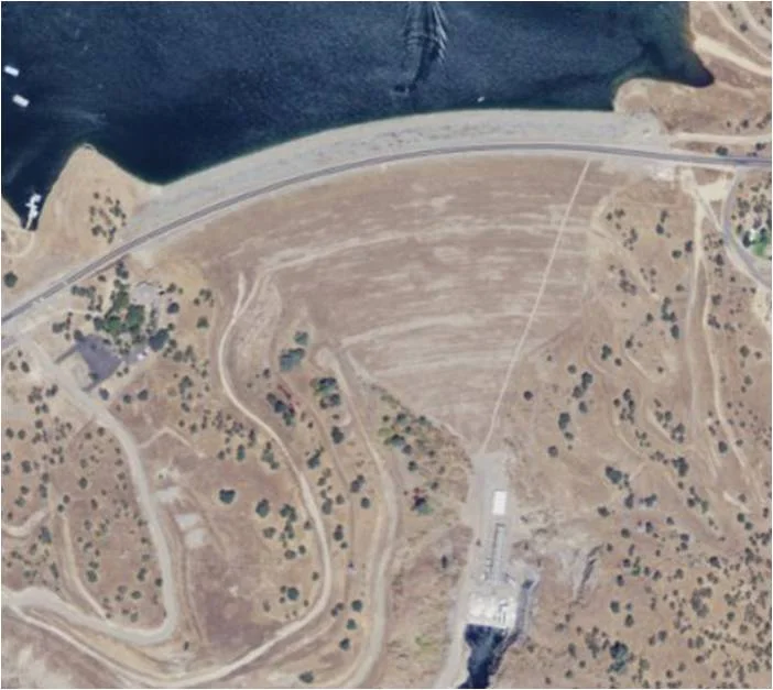
From the Air
New Don Pedro Dam is located at 37.70N, 120.42W on the Tuolumne River, approximately 2 miles northeast of La Grange, California. The massive earthfill dam and its sprawling reservoir are clearly visible from the air, with the reservoir stretching deep into the Sierra Nevada foothills. Best viewed at 3,000-5,000 feet AGL. Nearby airports include Modesto City-County Airport (KMOD) approximately 30 nm west and Columbia Airport (O22) about 20 nm east. Don Pedro Reservoir's multiple arms and coves make it a distinctive landmark. The old Don Pedro Dam site is submerged beneath the reservoir.
Nearby Stories
- Ferguson Fire 5.9 km away
- Fifteen Minutes at UC Merced 8.5 km away
- Gwen Araujo and the Law She Changed 23 km away
- Coarsegold, California 26 km away
- The Spinach Riot 42 km away
- Indian Grinding Rock State Historic Park 55 km away
- Mount Hamilton (California) 63 km away
- Mono Lake 77 km away