New Ireland Province
The province has been called three different names by three different sets of mapmakers. To the British explorer Philip Carteret, who in 1767 proved it was an island separate from New Britain, it was Nova Hibernia - Latin for New Ireland. To the Germans who colonized it in 1886, it was Neu-Mecklenburg. When Australia took the territory in 1914, the name reverted to an English translation of the Latin. The people who already lived there had, of course, been calling the place by their own names for roughly forty thousand years before any of the outsiders arrived. That's the span of human migration into New Ireland: at least three waves, stretching from deep prehistory into the Lapita pottery age around 3,300 years ago.
Geography of Water
New Ireland Province is the northeasternmost province of Papua New Guinea, anchored on a long main island and surrounded by a scattering of smaller ones with names that read like a sailor's roster: the Saint Matthias Group with Mussau and Emirau, New Hanover, Djaul, the Tabar Group with Tabar, Tatau, and Simberi, Lihir, the Tanga Group, and the Feni Islands sometimes called the Anir Islands. The land area is around 9,560 square kilometers. The Exclusive Economic Zone, the patch of ocean the province controls under international law, stretches to roughly 230,000 square kilometers. By any reasonable measure, New Ireland is more sea than land.
Teak and Labillardiere
During the early French Revolution, a vessel called La Recherche passed New Ireland while searching for a lost scientific expedition. On board was the botanist Jacques-Julien Houtou de Labillardiere, who noticed fine stands of teak (Tectona grandis) growing at the southern end of the island and wrote it down in his journal. He did not realize, or perhaps he did, that he was documenting the easternmost natural occurrence of the species on Earth. Teak's native range runs from India through Thailand, jumps to Java, and stops here, on an island that most European botanists had never heard of. Two centuries later the trees still grow, though the forestry industry has reshaped much of the lowland cover.
The De Rays Expedition
In the 1870s and 1880s, a French nobleman named the Marquis de Rays decided that New Ireland should become La Nouvelle France, a French colony on an island he had never visited. He sold shares in the venture to European settlers and sent four expeditions. The third of them, now remembered simply as the De Rays Expedition, was a catastrophe. Of roughly 350 settlers, 123 died, many from tropical disease, starvation, and the sheer difficulty of surviving on a coast where no European infrastructure existed. The survivors scattered. De Rays never saw his colony. The episode is one of those nineteenth-century colonial fever dreams that cost other people their lives, and the island absorbed the brief intrusion and moved on.
Blackbirding and the German Years
In 1886 Germany claimed the island as Neu-Mecklenburg. The decades that followed brought missionaries, plantation agriculture, and a labor practice called blackbirding - the kidnapping of young men, often at gunpoint, to work plantations in northern Australia and across the Pacific. Lihir Island and the Tanga Islands lost many of their people this way. The practice was widespread enough that it reshaped entire communities, and New Irelanders sometimes responded by capturing and killing the traders who came for them. When Australia took control in 1914 at the start of World War I, the island became part of the Mandated Territory of New Guinea, administered under a League of Nations arrangement. Japanese forces occupied the province from January 1942 to September 1945. Papua New Guinea gained independence in September 1975, and New Ireland became a province of the new nation.
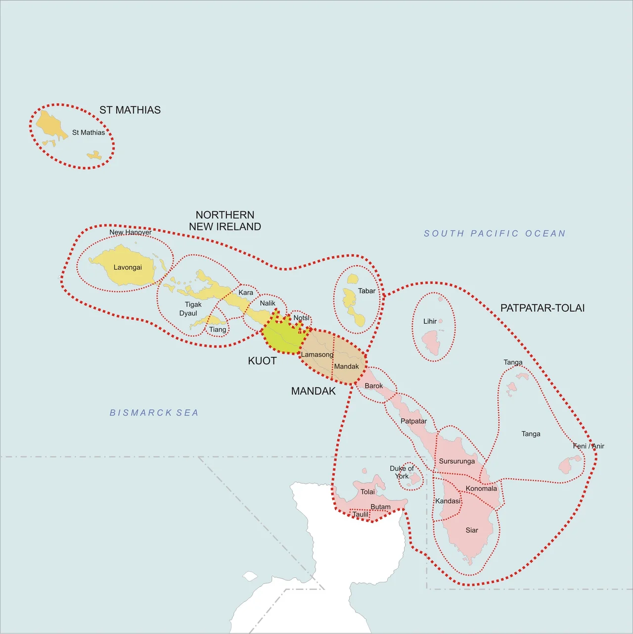
Malagan, Kuot, and the Languages of the Coast
Roughly twenty languages are spoken in New Ireland Province, with perhaps forty-five dialects and subdialects among them. All but one belong to the New Ireland group of the Austronesian family. The exception is Kuot, a language isolate - a language with no known relatives anywhere on Earth. What it survives from, and what it tells us about the island's deep history, is something linguists are still trying to figure out. Alongside Kuot lives Malagan, which is both a Nalik word and a cultural system. Malagan ceremonies honor the dead through elaborate carved masks that act as vessels for the spirits of recent ancestors. European administrators shipped many of these masks home during the colonial era, and they now fill European museum collections. The ceremonies continue in New Ireland, though rarer than before. Gold mining on Lihir and Simberi now anchors the modern economy alongside agriculture, livestock, forestry, and marine products. The old and the new coexist, which is to say they negotiate, constantly.
From the Air
New Ireland Province centers near 3 degrees south, 151.5 degrees east, stretching northwest from the main island through the Saint Matthias Group. Kavieng Airport (AYKV) on the northern tip is the primary airfield, with Lihir Island (LNV) serving the gold mine. The province's 230,000 square kilometers of EEZ means most flying here is over open ocean - plan fuel reserves and alternates accordingly. No tropical cyclones in this region because of proximity to the equator, but convective weather and sudden squalls are common. The islands appear as a chain of green dots against deep blue from altitude.
Nearby Stories
- Kavieng 27 km away
- New Ireland 29 km away
- New Ireland 32 km away
- Japanese cruiser Kako 52 km away
- Mining in Papua New Guinea 56 km away
- New Hanover Island 126 km away
- Bismarck Archipelago 201 km away