New Ireland
The island is shaped like a musket. That is how the old nautical guides described it, and the comparison has stuck - 360 kilometres of rugged mountain spine so narrow that in places it is barely ten kilometres across. Tok Pisin speakers call it Niu Ailan. The indigenous name is Latangai. It was named New Ireland in 1767 because the British liked to plant the names of home across the Pacific chart, and the Germans renamed it Neumecklenburg in 1885 for much the same reason. But the people who actually live here - Kuanua, Barok, Madak, Mandak, Patpatar, and others - have been carving masks for their dead and dancing with them into the grave for longer than any European name has existed. This is an island that has outlasted a lot of labels.
Deep Time on the Spine
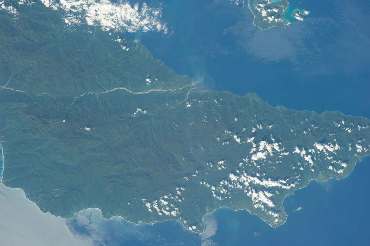
People reached these islands 33,000 years ago. That date - arrived at through careful dating of cave sites across the Bismarck Archipelago - puts New Ireland among the earliest human habitations anywhere in the Pacific. The first arrivals crossed from what is now the PNG mainland when sea levels were lower and the distances were shorter, but never zero. Even then, they had to sail. Three thousand years ago, the Lapita people came through - potters whose distinctive dentate-stamped ware is found from the Bismarcks to Samoa and marks the founding wave of Austronesian expansion into remote Oceania. New Ireland was a waypoint. The Hans Meyer Range rises to 2,340 metres at Mount Taron, and the central spine is so steep that even now, roads cannot cross it. Rainforest covers most of what has not been logged. The coast is narrow; the interior is almost unreachable.
The Marquis's Folly
Charles Bonaventure du Breil, Marquis de Rays, was a French aristocrat with a fantasy. In the 1870s he announced, from the safety of Marseille, that he was founding a colony on New Ireland called La Nouvelle-France. He sold shares. He sold titles. He sold 300,000 hectares of land he did not own on an island he had never seen. Four expeditions sailed between 1879 and 1881 carrying roughly 570 mostly Italian settlers toward what he had described as a tropical paradise with cleared land, waiting houses, and a functioning government. What they found was jungle. No clearing, no houses, no government, no food. The most disastrous expedition, the voyage of the India, saw 123 settlers die of fever, starvation, and exhaustion before the survivors were evacuated to Sydney and New Caledonia. The Marquis was eventually convicted of fraud in France. He spent six years in prison. The name La Nouvelle-France survives only in the records of one of the worst colonial scams of the nineteenth century.
The Malagan Rite
When someone dies on New Ireland - in the northern districts especially, among the peoples of the Tabar Group and the mainland facing it - the community does not simply bury them. The body goes into the ground. But the social death takes years. During that time, sculptors are commissioned to produce an elaborate wooden figure or mask called a malagan. These works - polychrome, openwork, alive with carved birds and fish and ancestral forms - are made to embody the deceased's spirit and to facilitate the mourning, the distribution of inheritance, and the final ritual severance that allows the living to move on. After a malagan ceremony, which can take weeks and involves dances, feasts, and the display of the carvings, the object itself is often destroyed or abandoned. It has done its work. Western museums are full of malagan that were removed before this final step, and the irony of preserving ritual objects that were made to be released is not lost on the people who carved them.
Boluminski's Road
Franz Boluminski was a Prussian administrator with a gift for making subjects build what he wanted. Between 1904 and his death from malaria in 1913, he ran the German colonial station at Kavieng and made the island work by ordering each village along the east coast to build and maintain its own section of road. By the time he died, the Boluminski Highway ran 265 kilometres down the spine of New Ireland, connecting Kavieng in the north to Namatanai in the south. It remains the island's main road today. The Germans built copra plantations along it - profitable operations that fed the European market for coconut oil. The road and the plantations made New Ireland the most functionally developed territory in German New Guinea. Whether the Tolai and Kuanua workers who laid the gravel and cut the palms would have chosen that particular road toward that particular future is a question German accounting did not think to ask.
The Forest and the Frame
In January 1942, Japanese forces captured New Ireland and held it until the end of World War II, using Kavieng as a naval base and digging the tunnel complex that still laces the hills above the town. The fighting ended. The plantations were rebuilt. Independence came in 1975. Since then, the larger pressure on the island has been logging. New Britain, Bougainville, and New Ireland together had about 60% of their forests accessible to timber operations, and by 2002 roughly 63% of those accessible forests had been deforested or degraded. The birds are quieter than they used to be. The rivers run more silt. The malagan carvers still work, though the old hardwoods are harder to find, and the ritual continues in the villages where the road still connects what Boluminski's scheme tied together a century and a third ago.
From the Air
Coordinates: 3.33°S, 152°E. New Ireland is a long, narrow island running northwest to southeast in the Bismarck Archipelago, separated from New Britain by Saint George's Channel. Kavieng Airport (AYKV, ICAO) at the northern tip is the main airfield, with a runway of about 1,540 metres. Namatanai at the southern end has a grass strip. The Hans Meyer Range reaches 2,340 metres at Mount Taron - plan for cloud buildup over the spine, especially in afternoons. Best viewed from 6,000-10,000 feet to appreciate the musket shape of the island and the contrast between forested mountains and coastal plantation fringe. The Boluminski Highway is visible as a ribbon along the east coast. New Hanover Island lies across a narrow strait to the northwest. Weather is tropical with frequent showers; expect turbulence near the mountainous spine in unstable air.
Nearby Stories
- New Ireland 4.6 km away
- New Ireland Province 28 km away
- Mining in Papua New Guinea 31 km away
- Japanese cruiser Kako 60 km away
- Kavieng 93 km away
- USS John A. Bole 174 km away
- Battle of the Green Islands 224 km away
- Raikoke 5702 km away