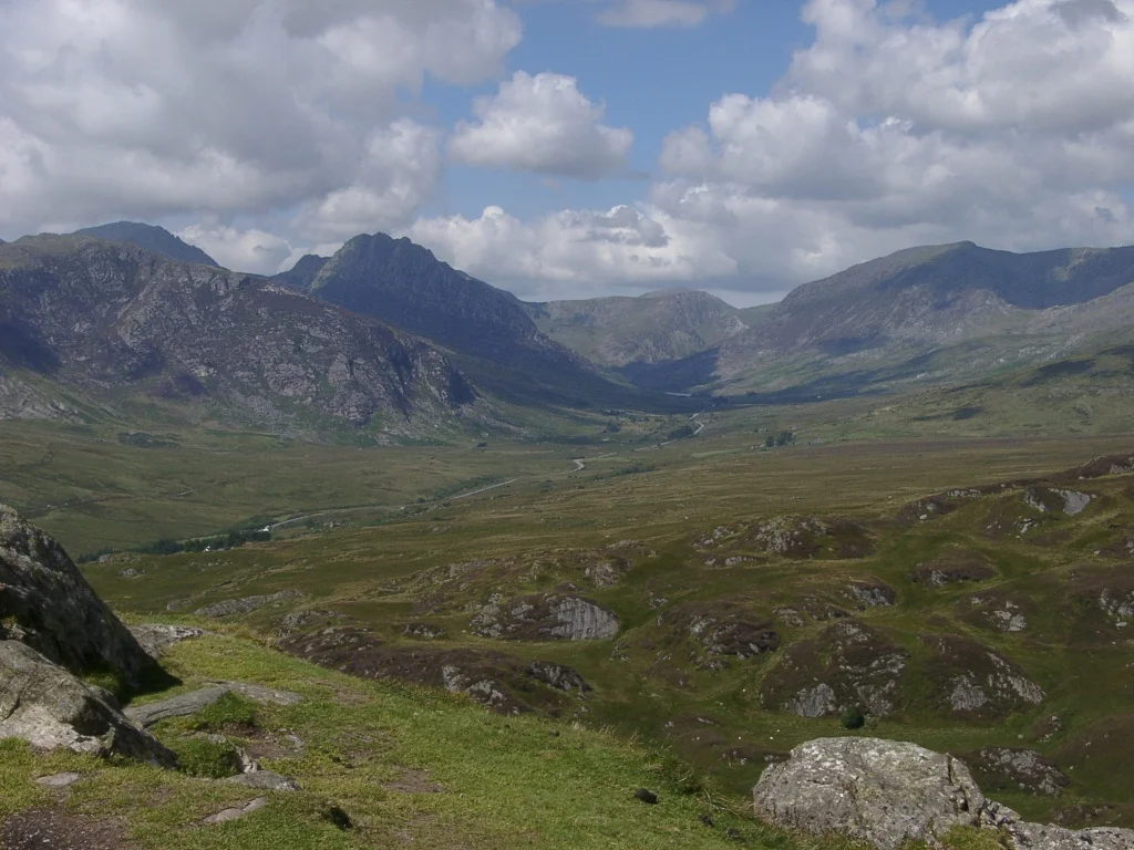

Ogwen Valley
Dyffryn Ogwen, the Welsh name, tells you exactly what the glaciers left behind. A U-shaped valley scooped clean by ice, walled on one side by the bristling crags of the Glyderau and on the other by the rounded sweep of the Carneddau. The River Ogwen threads the floor, gathers itself into Llyn Ogwen, and then plunges through the gorge at Nant Ffrancon. Stand at the head of the lake and you can see the whole story at a glance, the work of ice that finished here only twelve thousand years ago.
Two Ranges, One Valley
The Glyderau side is the dramatic one. Tryfan rises in a pointed wedge from the lake's southern shore, the most recognisable mountain in Britain, the kind of silhouette that schoolchildren can draw from memory. Behind it sit Glyder Fach and Glyder Fawr, summits stacked with shattered slabs that look more like sculpture than stone. The Carneddau side rolls higher and gentler, broad whaleback ridges that hold the largest expanse of land above three thousand feet in Wales outside the Snowdon massif. Between them, in a hanging valley above Llyn Ogwen, the climbing slabs of Cwm Idwal rise like a vertical stage. The Idwal Slabs were where British climbing learned its trade in the years between the wars, and they still draw climbers on every dry weekend.
The Slate Years
Bethesda anchors the valley's northern end, and Bethesda is a slate town through and through. Penrhyn Quarry, the great pit that crowned the Welsh slate industry, lies just to the north, and at its peak more than three thousand quarrymen walked from the terraced rows of Bethesda to the workings each morning. Roughly twenty thousand people lived in the valley in the early twentieth century, three-quarters of them Welsh speakers, and the chapels and rugby clubs and choirs grew from that density. The slate industry crashed from the 1960s onwards, and the population fell with it. About six and a half thousand people live here now, and unemployment runs near twenty percent. Every ward in the valley sits among the poorest tenth in Wales. The land that produced the slate that roofed the world remembers what was taken.
Mountain Rescue and a Zip Line
Ron James ran the outdoor pursuits centre at Ogwen Cottage in the 1960s, and he watched walkers and climbers come into trouble often enough that he started organising rescues himself. That informal arrangement became the Ogwen Valley Mountain Rescue Organisation, which still answers the call when someone gets benighted on Tryfan or a leader peels off the Idwal Slabs. The valley has reinvented itself for recreation in other ways too. Zip World runs Velocity 2 over the flooded floor of Penrhyn Quarry, the longest zip line in Europe, which sends adventure tourists hurtling along at over a hundred miles an hour above water that once held quarrymen's tools.
World Heritage, World Stage
In 2021 UNESCO inscribed the Slate Landscape of Northwest Wales as a World Heritage Site, and the stretch from Bethesda to Port Penrhyn forms part of the designation. The recognition acknowledges what the valley already knew, that the terraced workings and inclines and tramways are not industrial ruins but a complete cultural landscape. Filmmakers have noticed too. ITV's Mr Bates vs The Post Office shot here, and House of the Dragon found its dragonriding country at the head of Nant Ffrancon and around Llyn Idwal. The same wind-scoured cwms that drew Victorian geologists now stand in for Westeros. The valley has been many things. It is still itself.
Walking Country
Most visitors come for the walking. The A5, Telford's old Holyhead road, slips along the valley floor between Capel Curig and Bethesda, and from any layby you can step out into mountain terrain that begins steep and stays steep. The Idwal Cottage hostel sits at the lake's western end, the obvious starting point for Cwm Idwal and the round of the Glyderau. Cattle grids, sheepdogs, and the white scribble of dry-stone walls climb partway up the slopes before the bracken takes over. Above the bracken there is rock, mist, and silence. The valley keeps its working face. It also keeps its wilder one.
From the Air
Ogwen Valley sits at 53.13 degrees north, 4.00 west, a U-shaped glacial trough running roughly southeast to northwest between the Glyderau and Carneddau in Eryri (Snowdonia). Recommended viewing altitude 4,000 to 6,000 feet above the valley floor for the full sweep of the trough; higher to catch the surrounding peaks. Tryfan's pointed silhouette on the south side is unmistakable. Mountain weather can change quickly with low cloud filling the valley. Nearest airports EGCK Caernarfon to the southwest and EGOV Valley on Anglesey to the northwest. EGNR Hawarden lies further east.
Nearby Stories
- Tudweiliog 3.6 km away
- Denbigh Castle and Town Walls 6.4 km away
- Rhoscolyn Lifeboat Station 7.6 km away
- Butlin's Pwllheli 20 km away
- East–West Interconnector 20 km away
- New Brighton Lifeboat Station 31 km away
- Battle of Oswestry 31 km away
- Celtic Array 44 km away