
Orangozinho
The name is a diminutive: Orangozinho, "Little Orango," a smaller island in the shadow of its larger neighbour at the southern edge of the Bijagós Archipelago. But there is nothing slight about the life packed into its flat, flooded acres. Nearly half the island lies under tree cover, most of it dense mangrove, and the dry land between is given over to rice, palms, and the villages of the Bijagó. This is a place where the horizon is low, the water is everywhere, and the rhythm of every day is set by the rise and fall of the Atlantic.
An Island the Tide Built
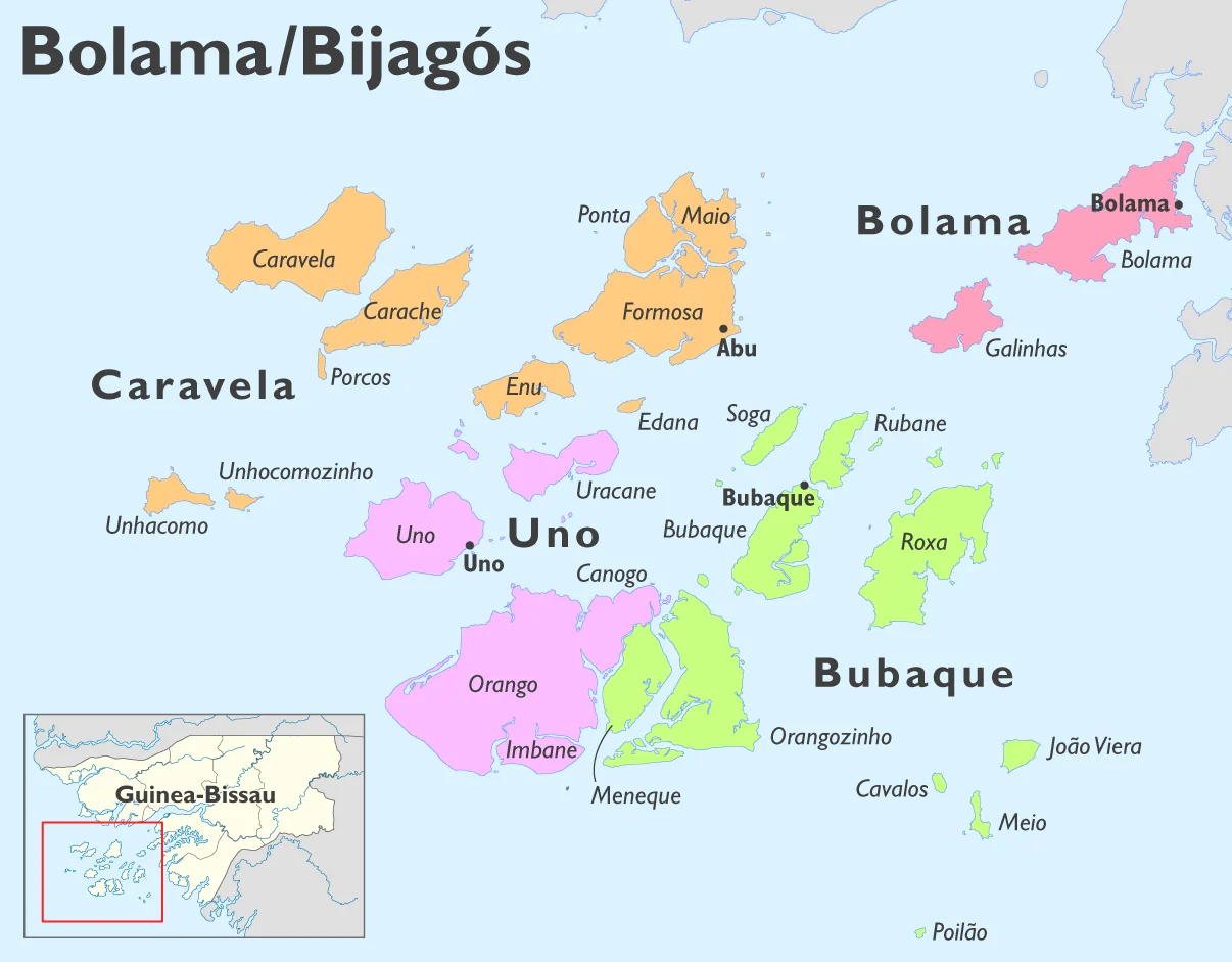
Orangozinho sits within the deltaic system fed by the Geba River, a realm of mangroves, mudflats, savanna, and tidal zones spread across dozens of islands. The land barely lifts above the sea. Plains and tidal wetlands dominate, and the highest ground is modest. Bubaque lies to the north, Canhabaque to the northeast, Meneque to the west, Canogo to the northwest, all of them part of the same drowned, green archipelago. Along with its neighbours, Orangozinho falls within Orango National Park, sharing the protection given to the region's saltwater hippos, sea turtles, and mangrove nurseries.
The People of Wite
As of the 2009 census, about 706 people lived on Orangozinho, most of them in the village of Wite. They are entirely Bijagó, speaking their own languages alongside Guinea-Bissau Creole. Theirs is a matrilineal society in which women hold decisive roles in property, marriage, and the decisions that govern village life. The pattern is not a relic preserved for visitors but the working structure of a community that has farmed, fished, and worshipped here for generations, holding to animist traditions through every change the wider country has weathered.
Living by Fishing and Rice
Subsistence fishing in the coastal shallows and tidal creeks is the mainstay, supplemented by gathering shellfish and crabs from the mudflats at low water. On the firmer ground, families grow rice, tubers, and vegetables, and tend oil palms. It is a livelihood measured by the tide and the season rather than the clock. In recent years a careful ecotourism has begun to take root, drawing on Orango Park initiatives that bring small numbers of visitors to see the wildlife and meet the communities, on terms the islanders set.
A Quiet Corner of the Archipelago
There is a stillness to a place like this that is hard to find elsewhere. No high ground breaks the view; the land lies flat against the sky, fringed by the dark green of mangroves and edged with channels that flood and drain with the moon. For a navigator it is a useful landmark, a distinct mass of green in a sea of islands. For the people of Wite it is simply home, one of the last corners of West Africa where the old ways of living with the water have not yet been swept aside.
From the Air
Orangozinho lies at roughly 11.12°N, 15.93°W in the southern Bijagós, east of Orango proper and within Orango National Park. From the air the island reads as a low, flat green shape, nearly half cloaked in mangrove, ringed by mudflats and tidal channels that bare and flood with the Atlantic tide. Neighbouring Bubaque sits to the north. Best viewed in dry-season light from December to April; Harmattan dust and coastal cloud reduce visibility. Nearest international airport is Bissau (GGOV); the islands are reached by boat.
Nearby Stories
- Poilão 31 km away
- Boké Museum 131 km away
- Nadir Crater 178 km away
- Pongo River (Guinea) 180 km away
- Dakar 377 km away
- Gouina Falls 554 km away
- Bafoulabé 620 km away
- SS Noemijulia 810 km away