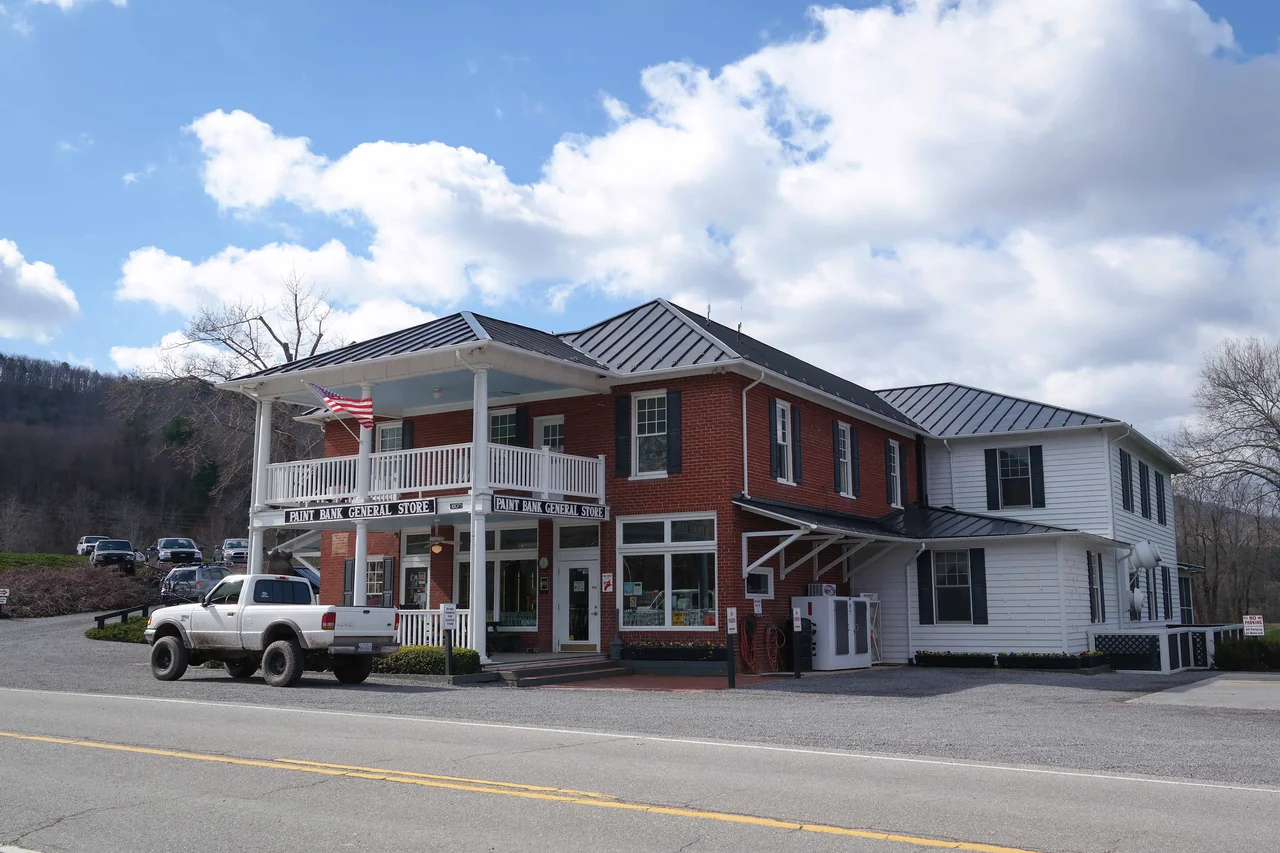

Paint Bank, Virginia
The Cherokee came here for the color. The banks of Potts Creek - just above where it flows out of Virginia into West Virginia - exposed seams of iron-rich red clay and ochre, vivid enough to use as war paint and as the slip that colored Cherokee pottery a distinctive deep red. Early maps and deeds caught the practice and gave the place the only name that has ever stuck: Paint Bank, sometimes Indian Paint Bank or Painted Banks. Today the village sits at the intersection of Virginia Routes 18 and 311, an unincorporated community in northern Craig County, squeezed between Potts Mountain and Peters Mountain. The Cherokee pigments are still in the ground. Almost everything else about Paint Bank has changed at least three times.
Bricks of the Same Red
European settlers reached the valley in the 18th century. By the early 1800s, the same red clay that had colored Cherokee pots was being mixed with binders and sold as commercial paint - and pressed into the bricks that built the village's permanent buildings. The Paint Bank General Store, which still operates today, was built from these locally-fired red bricks. Land grants from Lord Fairfax and from the Commonwealth of Virginia, dating from the 1820s through the 1850s, divided up the surrounding ridges among speculators and settlers. The Sweet Springs and Price's Mountain Turnpike ran through Paint Bank during the stagecoach era, making it a regular stop between Fincastle, Virginia and Sweet Springs, West Virginia. A few miles up that road sits the home site of Anne Royall, born 1769 - by some accounts the first professional female journalist in America.
The Union Hole
When Virginia seceded in 1861, the village picked the unpopular side. Paint Bank became the core of what local farmer George A. Linton called the Union Hole - an area of mixed loyalties that leaned, sometimes heavily, toward the North. The Order of the Heroes of America, known as the Red Strings for the red yarn members tied to their lapels, organized chapters here that helped Union deserters and resisters slip across the lines. The community sheltered men who would not fight for the Confederacy. Union General David Hunter passed near here in 1864 on the difficult trek from Lynchburg to Sweet Springs that included some of the campaign's hardest mountain fighting. The geography that had brought the Cherokee to these creeks also made the village a useful hiding place: hard to reach, easier to leave.
Tingler's Mill and Five Different Counties
Colonel William Preston, a Revolutionary War veteran, received land grants here in 1780 and built a grist mill on Potts Creek to grind corn and wheat. The mill changed hands repeatedly over the centuries and eventually became known as Tingler's Mill. The current building dates to 1873, but the mill site has been continuously operating, in one form or another, on the same spot since 1783. Without ever moving, the mill has belonged to two states and five different counties: Botetourt County, then Monroe County of Virginia in 1851, then Craig County when it formed in 1857, then briefly under West Virginia jurisdiction during the 1863 statehood reorganization, then back to Virginia. As the Craig County Historical Society notes, the boundary lines kept rearranging themselves around a mill that never moved an inch.
The Punkin Vine and the Hatchery
Paint Bank's brief industrial boom came in the early 1900s. The Big Stony Railway, extended from the Norfolk and Western mainline at Ripplemead, reached Paint Bank in 1909 as the Potts Valley Branch - locally known as the Punkin Vine. Daily trains carried out iron ore, manganese, and timber, and brought in passengers and goods to a village that briefly held more than 2,000 residents. The Train Depot dates to 1909, the Section Foreman's Cottage to 1910. The Depression pulled out the tracks in the 1930s. What replaced the boom was quieter: a Virginia Department of Wildlife Resources fish hatchery, established by act of Congress in 1956, that today raises brown, brook, and rainbow trout in tanks holding up to 1.6 million fish at a time. The trout are released at 18 months old and stock streams in nine counties. Glenvar High School ecology students help raise some of the hatchlings, which survive at about a 10 percent rate compared with 1 to 3 percent in the wild.
Aviator's Notes
Paint Bank sits at 37.57 N, 80.26 W, in the long ridge-and-valley country of western Craig County, Virginia, just over the ridge from Monroe County, West Virginia. The village lies in the narrow valley of Potts Creek between Potts Mountain (to the west) and Peters Mountain (to the east), both rising above 3,500 feet. The nearest commercial airport is Greenbrier Valley Regional (KLWB) at Lewisburg, about 20 nautical miles northwest. Roanoke-Blacksburg (KROA) sits about 35 nautical miles east-southeast. From altitude the village reads as a small clearing where two creeks meet, with the linear Peters and Potts ridges as the dominant landmarks. The ridges generate orographic turbulence in strong westerlies.
From the Air
Located at 37.57 N, 80.26 W in the Potts Creek valley of western Craig County, Virginia, between Potts Mountain (W) and Peters Mountain (E), both rising above 3,500 feet. Nearest airports: Greenbrier Valley Regional (KLWB) at Lewisburg approximately 20 nm NW, Roanoke-Blacksburg (KROA) approximately 35 nm ESE. Recommended viewing altitude 6,500-8,500 feet. The Peters Mountain ridge is a useful linear landmark. Watch for orographic turbulence in strong westerlies and afternoon thunderstorms in summer.
Nearby Stories
- Botetourt County, Virginia 2.3 km away
- White Sulphur Springs, West Virginia 2.5 km away
- Blacksburg 8.6 km away
- Concord University 17 km away
- Murders of Alison Parker and Adam Ward 18 km away
- Babcock State Park 24 km away
- Garth Newel Music Center 26 km away
- Bluefield, West Virginia 32 km away