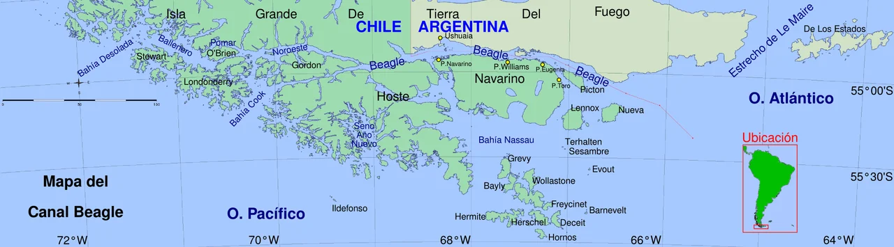

Picton, Lennox and Nueva
Three islands lie scattered at the very tail of South America, east of Navarino, where the Beagle Channel finally surrenders to the open Atlantic. Picton, Lennox and Nueva are mostly empty: tussock grass, peat, seabirds, and the relentless wind off Cape Horn. Yet in December 1978 these obscure scraps of land brought two nations to the edge of catastrophe. Argentine and Chilean fleets steamed toward each other in the dark, troops were poised, and a war between them was a matter of hours away. What stopped it was a letter from Rome.
Named by Strangers
The islands carry names assigned by people passing through. The British surveyors Robert FitzRoy and Phillip Parker King christened Picton after Sir Thomas Picton, the first British governor of Trinidad. Lennox had first been sighted in 1624 by the Dutch admiral Schapenham, whose crew called it Terhalten before FitzRoy renamed it. Long before any European chart, the Yámana paddled these channels in bark canoes, hunting seals and gathering shellfish along shores that froze and thawed with the southern seasons. By the late nineteenth century the Chilean government was parceling out grazing concessions; one of them, on Picton, went to Thomas Bridges of nearby Harberton. Tiny settlements with names like Puerto Piedra and Caleta Oro flickered into existence and mostly faded again.
The Line in the Water
The trouble was a single geographic question with no obvious answer. Did the Beagle Channel, and therefore the border, run north of the three islands, making them Chilean, or south, making them Argentine? A 1977 arbitral award handed the islands to Chile. In January 1978 Argentina's military junta rejected the ruling outright. The stakes were never really about the islands themselves; they were about the maritime territory and the access to the Atlantic and the rich seas beyond. Two dictatorships, each desperate to look strong, locked themselves into a confrontation neither could easily abandon.
Hours From War
On 22 December 1978, Argentina launched Operation Soberanía, a plan to seize the islands and strike the Chilean mainland. Warships moved into position. Then, only hours in, the operation was called off, partly because of foul weather and partly because of what was arriving from the Vatican. Pope John Paul II had sent both presidents a personal plea for peace, and now he dispatched a mediator. In January 1979 the two countries signed the Act of Montevideo and accepted papal mediation. It took years more, but in 1984 a treaty signed in the Vatican gave the islands to Chile while splitting the surrounding waters. The peace held. It very nearly had not.
Scars and Stories
The brush with war left physical marks. Minefields were laid here, some of the last installed shortly after Argentina turned its attention to the Falklands in 1982, and from 2007 Chilean army and navy de-mining units worked for years to clear them. This was not the islands' first taste of distant wars, either. In December 1914, after the Battle of Coronel, Admiral Graf Spee's German squadron moored briefly off Picton on its way to disaster at the Falklands, an intrusion that pushed neutral Chile to fortify the anchorage. The same little harbour later helped fuel the Yelcho on her famous voyages to rescue Shackleton's stranded men from Antarctica. There is a literary footnote, too, fitting for so remote a place. Jules Verne set a late novel, Magellania, on Nueva Island, imagining a man called Kaw-djer whose motto was Neither God nor master and who wanted only to live beyond the reach of any flag. The 1881 boundary treaty, in Verne's telling, destroys his anarchist paradise by ending the region's status as land belonging to no one. It is a strange irony that the real islands would nearly trigger a war over exactly that question: whose land is this, at the end of the earth?
From the Air
Picton, Lennox and Nueva lie at roughly 55.03°S, 66.95°W, east of Navarino Island and south of the Argentine portion of Isla Grande, separated from it by the Beagle Channel. The nearest civil airfield is Ushuaia – Malvinas Argentinas (SAWH) to the northwest; Puerto Williams (SCGZ) on Navarino Island is the closest Chilean field. From altitude the three islands read as low, treeless landmasses ringed by white surf where the channel meets the Atlantic; Picton lies nearest Navarino, with Lennox and Nueva to the southeast. Recommended viewing altitude is 3,000–6,000 ft. Expect powerful westerly winds, fast-moving cloud, and frequently poor visibility; clear windows are brief and prized.
Nearby Stories
- Villa Ukika 20 km away
- Cerro Castor 36 km away
- Cabo de Hornos National Park 52 km away
- Tierra del Fuego 77 km away
- Isla de los Estados 141 km away
- Sinking of ARA General Belgrano 310 km away
- New Island 508 km away
- West Antarctica 2886 km away