.jpg)
Plaza de la Independencia
Before it was the central stage of a republic, Plaza Grande was a watering hole. In the earliest years after Quito's founding, this was simply an esplanade of packed dirt - a flat open space that happened to contain a useful water source, convenient for the neighbors fetching water for their households. For decades, no one thought of it as the heart of the city. That role belonged to what is now called Plazoleta Benalcázar, the tentative original square of the new Spanish town. Only in 1612 did the balance tip. Civic institutions had begun clustering on the larger esplanade's flanks. The city decided to call this one simply Plaza Grande - the big plaza - because it was. Four centuries later, after a republican revolution and a colonial re-dedication, it still is.
Four Buildings and a Fountain
The buildings that surround the square today all date, except for one, to the colonial period. To the southwest: the Cathedral of Quito, where the Catholic Church acquired land on the north and south sides early in the square's history and built the city's main temple. To the northeast: the Archbishop's Palace and what is now the Hotel Plaza Grande - built as the Palacio Hidalgo by Captain Juan de Díaz Hidalgo, one of the city's founders, on a corner lot he reserved for himself. The Hidalgo palace remains the only private building on the square that has endured to the present. To the northwest: Palacio de Carondelet, the presidential palace, built on the western end after the earthquake of 1627 destroyed the original founders' houses there. To the southeast: the Municipality of Quito, the sole modern structure, built in the 1970s to replace a colonial city council building demolished for the purpose.
Garden of the Royal Audience
In the eighteenth century, someone thought of the plaza as a true European-style square for the first time. The president of the Royal Audience of Quito conceived landscaping that would serve as a formal garden for Palacio de Carondelet. The palace topped its steps directly in the plaza, and cart traffic was prohibited on the western edge - the side facing the presidential building. The square became something closer to the elegant spaces found in Spanish and French capitals. By the early nineteenth century, practicality reasserted itself. The palace steps were pulled back to end on the side streets. Carts were allowed to pass again on what was then called Calle de las 7 Cruces, today's Calle García Moreno. The transformation from dusty esplanade to urban stage was incremental, each generation adjusting the plaza for its own needs while leaving the central geometry intact.
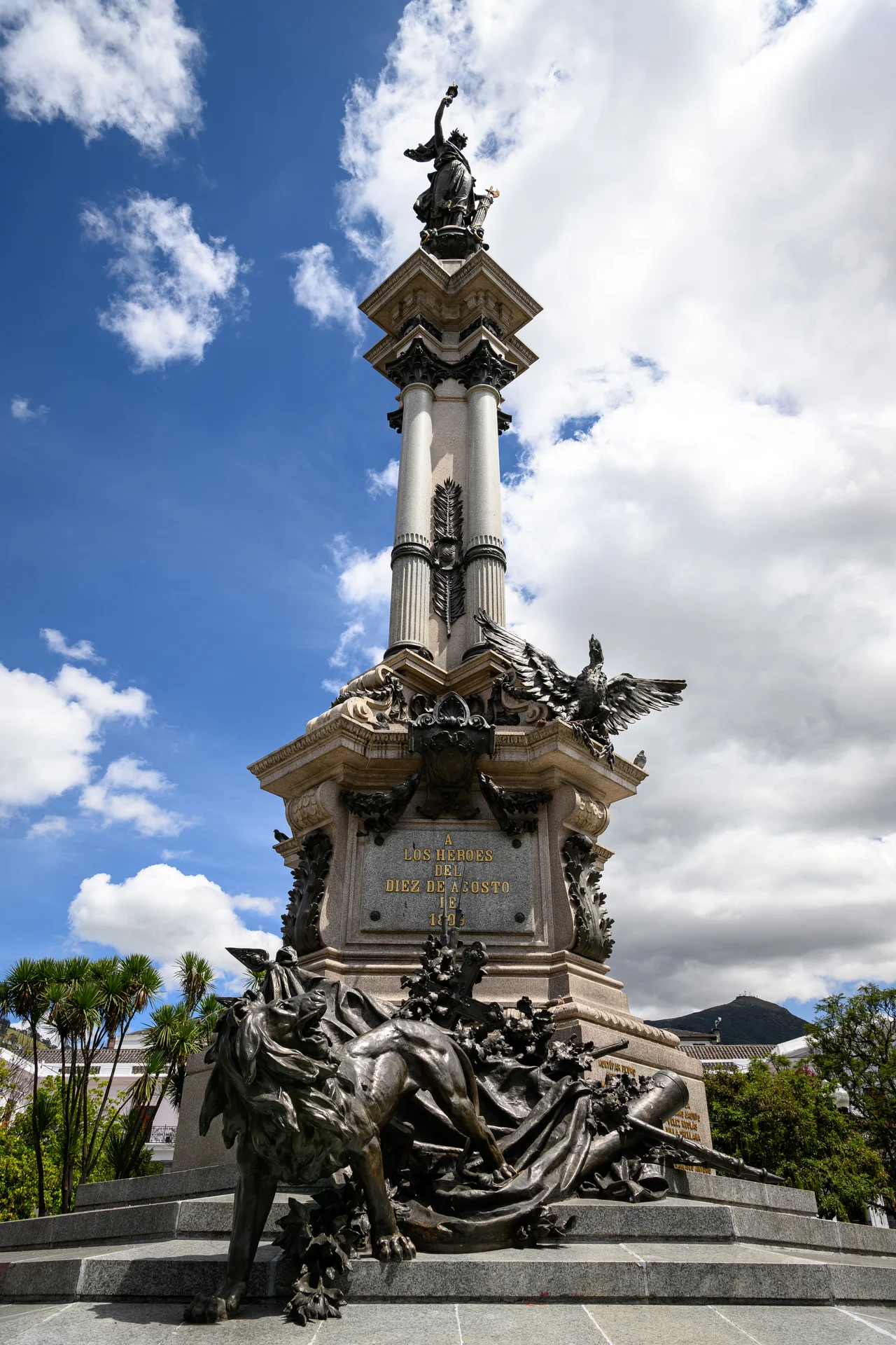
The First Cry of Independence
On 10 August 1809, a group of Quito Creoles met in the house of Manuela Cañizares - one block from this plaza - and declared the overthrow of the Spanish Royal Audience. The uprising failed within days. The leaders were arrested and executed. But the date stuck in the Ecuadorian national memory as the Primer Grito de la Independencia - the First Cry of Independence - and Quito claimed priority over the broader South American liberation movements that followed over the next decade. For almost a century, the plaza at the city's core had no formal marker of the event. Then President Eloy Alfaro, after years of petitions from municipal authorities, ordered a monument to commemorate the centennial. A French sculpture was commissioned in 1898 and placed at the center of the square, replacing the colonial fountain which was shifted to the southwest corner. In a public ceremony on August 10, 1906, the President and Mayor unveiled the Independence Monument. With the same ceremony, the colonial name Plaza Grande became Plaza de la Independencia.
A Square That Would Not Change
Since 1906, the plaza has barely changed. The Independence Monument still rises from its center. The fountain still sits in the southwest. The four colonial facades still look onto each other across the same rectangle of light. The corners hold four more notable buildings: the historic Banco del Pichincha, the House of Manuela Sáenz - now home to FONSAL, the agency that maintains Quito's historic core - the Alberto Mena Caamaño Museum, and the Church and Convent of the Immaculate Conception. Surrounded by four streets bearing four pieces of Ecuadorian history - Calle Venezuela, Calle Chile, Calle García Moreno, and the pedestrianized stretch of Calle Eugenio Espejo - the square continues to serve as the symbolic center of executive power and national identity. Every presidential inauguration still takes place within sight of the fountain that once served the neighbors' horses.
From the Air
Located at 0.22°S, 78.51°W in Quito's Old Town at 2,850m elevation. The plaza forms the geometric center of the UNESCO-listed historic core, surrounded by four colonial facades: Cathedral, Archbishop's Palace, Presidential Palace, and Municipality. Viewing altitude 4,500m reveals the narrow north-south Andean valley holding Old Quito, with the plaza visible as the largest open rectangle within the dense grid of red-tiled roofs. Nearest airport: Mariscal Sucre International (SEQM) 18nm east at Tababela. The Pichincha volcano (4,784m) rises to the immediate west; the plaza sits at the traditional heart of the elongated city that follows the valley floor.
Nearby Stories
- Pululahua Geobotanical Reserve 13 km away
- Illiniza 21 km away
- Baeza 28 km away
- La Mana 48 km away
- Quinindé Canton 56 km away
- Tena 57 km away
- Guandera Biological Station 76 km away
- Valencia, Ecuador 82 km away