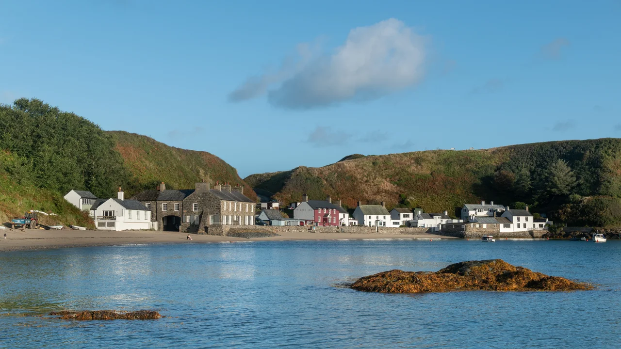

Porthdinllaen
In 1806 Parliament passed an act to build new harbour works at a small Welsh fishing village on the Llyn Peninsula. The plan was to make Porthdinllaen, not Holyhead, the principal port for the route from London to Dublin. The two harbours were almost equally far west, and Porthdinllaen was sheltered by a north-jutting headland that made it one of the safest anchorages on the entire Welsh coast -- a hundred acres of good holding ground in all but a north-easterly gale. The Porthdinllaen Harbour Company was formed in 1808 by the Jones Parry family of nearby Madryn estate. Then, in 1810, the parliamentary bill failed. Thomas Telford had been building roads to Holyhead, and Holyhead won. Porthdinllaen stayed a fishing village. Two centuries later, the loss looks remarkably like a win.
Two Dozen Cottages and a Pub
There are about two dozen buildings at Porthdinllaen and one of them, the Ty Coch Inn, is the village. The pub sits directly on the beach, painted red, looking out at boats moored in the bay. The Ty Coch has been repeatedly named one of the best beach bars in Britain and the world. The hamlet has been owned by the National Trust since 1994, which means no commercial development, no new building, no expansion. Cars are restricted to residents with permits. Everyone else walks: either across the beach from Morfa Nefyn at low tide, or over the headland on a footpath that crosses the Nefyn and District Golf Club's cliff-top course, passing the remains of an Iron Age hillfort on the way. The walk is part of the experience. Arriving at Porthdinllaen by car feels wrong even when you are allowed to.
Pigs to Liverpool, Salt for Herring
Before the National Trust, before the tourism, Porthdinllaen worked for its living. Pig farming was a mainstay of the Llyn economy, and Porthdinllaen was where the pigs left -- shipped to Liverpool from the small pier. In 1830 the local farmers and merchants asked the Madryn estate to build a larger pier to handle more trade; the estate refused, and the first steamer to call at the harbour, the Vale of Clwyd, did not arrive until 1832. Salt came in by the boatload, used to cure the Nefyn herring -- the staple catch of the bay. The headland that sheltered the harbour had been important for centuries: archaeologists date the hillfort above it to the Iron Age, and the natural shelter meant any storm in the Irish Sea sent ships running for Porthdinllaen rather than risking the open Llyn coast. Over 700 vessels passed through the port in 1861 alone.
The Lifeboat That Speaks Welsh
In 1864 the Royal National Lifeboat Institution established a station at Porthdinllaen, and it has been crewed continuously ever since. It is the only RNLI station in Britain where Welsh is the normal working language of the crew. The current boat, the all-weather Tamar-class John D. Spicer (ON 1304), has been on station since 2012 and was funded by a bequest from John Dominic Spicer of Oxfordshire, who died in 2010. The new boathouse, opened in April 2014, cost eight million pounds. Because the only land access ran across the golf course and along the headland, and because the local population objected to a new road, the RNLI chose to deliver every construction material by sea. The same approach had worked at Tenby a few years earlier. The boathouse rose from the bay outward. Today it is one of the RNLI's Explore stations, with public access and a gift shop in summer.
Half Light and the Cinematic Bay
Because Porthdinllaen looks almost exactly the way a Welsh fishing village would have looked in 1850, it gets used for filming. In September 2004 it stood in as a Scottish fishing village for the Demi Moore romantic thriller Half Light. The bay's preservation is not accidental: National Trust ownership has frozen the silhouette of the place, and the absence of cars keeps the soundtrack right -- gulls, halyards on masts, the muffled conversation outside the Ty Coch. The view from the beach takes in Yr Eifl's three peaks to the east and Snowdonia's higher massif behind them. Visitors who walk in for the day usually time their return for an outgoing tide, so they can cross back to Morfa Nefyn along firm sand. Anyone who fails to check the tide tables can be stuck for hours, drinking another pint at the Ty Coch while the bay fills behind them. It is, on the whole, a forgivable mistake.
From the Air
Located at 52.94N, 4.57W on the north-west coast of the Llyn Peninsula, sheltered behind a headland that projects north-west into the Irish Sea. Caernarfon Airport (EGCK) lies 16nm east. RAF Valley (EGOV) lies 21nm north on Anglesey. Best viewed at 1,000-2,000ft AGL on a coast-following track. The harbour and small cluster of red and white cottages are unmistakable, with the Nefyn golf course on the headland behind. On a clear day, Yr Eifl rises to the east-south-east.
Nearby Stories
- GeoMôn 1.9 km away
- Battle of the Conwy 3.2 km away
- Irish Sea Bridge 5.2 km away
- Ysbyty Ifan 10 km away
- Machynlleth 16 km away
- Barmouth Lifeboat Station 23 km away
- Irish Sea 27 km away
- HMS Tyler 32 km away