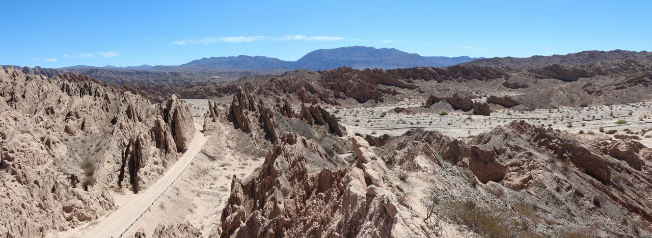

Quebrada de Las Flechas
The rock points the wrong way. Everywhere else, sediment lies down in patient horizontal beds, the oldest on the bottom, the youngest on top. Here, along a 20-kilometer stretch of Argentina's National Route 40, the layers stand nearly upright, tilted on end and sharpened to edges, so that the ground itself seems to be aiming at the sky. The Spanish name says it plainly: Quebrada de Las Flechas, the Ravine of the Arrows. Drive into it and the walls close to within a few meters, gray and reddish-brown blades rising twenty meters on either side, and the road threads between them like a needle finding its way through stone.
A Landscape Stood on End
What looks like sculpture is the residue of catastrophe in slow motion. Between fifteen and twenty million years ago, as the Andes heaved upward, deep faults in the earth's crust forced blocks of ancient crystalline rock skyward. The sandstone plates that had settled flat, long before the mountains existed, were caught in the upheaval and folded almost vertical. Geologists call this rock the Angastaco Formation, named for the village that guards the ravine's northern gate, because it is here that the formation reaches its fullest, strangest expression. Erosion did the finishing work, planing away softer material until the harder strata stood out as fins and points. The most famous of them, the Paso de la Flecha, resembles a petrified glacier bristling with spikes. In 1995 the province declared it a natural monument, and made the whole ravine one of Salta's official symbols.
The Hour Changes Everything
Light is the ravine's second sculptor, and it never carves the same shape twice. In the morning the formations glow bright, almost bone-pale; by afternoon they deepen into ochre and rust, the reddish-brown sandstone catching the low sun. Travelers who know the place time their crossing for the golden hours and avoid the flat glare of midday, when the heat radiates off the stone and the dust hangs in the air. The road is consolidated gravel, bumpy on the southern approach from Cafayate, and the advice repeated by everyone who has driven it is the same: take it slowly, and never at night. A few bolder souls skip the road entirely and ride through on horseback under a full moon, following the bed of the Calchaquí River instead, where the pale rock turns silver and the silence is total.
A Church That Hangs From the Cliff
Near kilometer marker 4420, where the blades briefly relent, sits the oldest Jesuit church in the entire Calchaquí Valley, built of adobe in 1780 and restored in 1969 by the owners of the surrounding Finca El Carmen. Its cane roof and two brightly painted altars look out over the valley, the little building seeming almost to dangle from the edge of the ravine. Cross the river from there and you walk among rocks far older than any church. The people of the Santa María culture lived in these valleys long before Spanish boots arrived, and they left their dead in funerary urns and shaped clay vessels that still surface among the stones. The arrows of rock that draw photographers today were, to those earlier people, simply home.
A Refuge for Wings
For all its severity, the Quebrada is not lifeless. The surrounding region is recognized as one of Argentina's Important Bird Areas, a designation reserved for places critical to the survival of bird populations. In a landscape this arid, the river corridor and the shelter of the rock walls become essential. The contrast is part of the place's strange logic: a valley defined by stone that seems hostile to everything, yet quietly indispensable to the creatures that ride its thermals between the spires. Cyclists pedal through in summer despite the heat and the wide swing between day and night temperatures, drawn by the same thing that pulls everyone else into the gauntlet of arrows: the chance to pass through a piece of the planet caught in the act of standing up.
From the Air
Quebrada de Las Flechas lies at approximately 25.70°S, 66.13°W in the San Carlos Department of Salta Province, threaded by National Route 40 between Angastaco and the Calchaquí River, at valley-floor elevations near 2,000 meters. The nearest major airport is Martín Miguel de Güemes International at Salta (ICAO SASA / IATA SLA), about 260 km away by the Cafayate road; Cafayate itself has a small local aerodrome roughly 80 km to the south. From the air, the formation reads as a tight band of parallel ridges casting hard shadows across an otherwise broad desert valley. For the most dramatic relief, fly the corridor in early morning or late afternoon when low sun rakes the upright strata; midday light flattens them. Clear, dry skies are the norm in this high-desert region, with the best visibility outside the summer rainy season.
Nearby Stories
- Cafayate 30 km away
- Los Cardones National Park 41 km away
- Museum of High Altitude Archaeology 85 km away
- Tafi del Valle 95 km away
- 1692 Salta Earthquake 102 km away
- Tolar Grande 117 km away
- Londres, Catamarca 192 km away
- Llullaillaco 209 km away