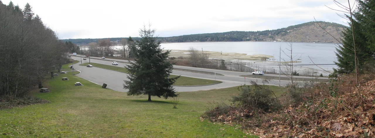

Red Gap, British Columbia
The town took its name from a place that never existed. In 1917 the sawmill settlement on the flats of Nanoose Bay needed something official to put on a post office application, and somebody reached for the popular novel of the moment -- Harry Leon Wilson's Ruggles of Red Gap, published two years earlier, a comedy about an English valet turned loose in a fictional western town. Hollywood liked it too: a film followed in 1918, and two remakes after that. So a real community on Vancouver Island spent thirty-odd years carrying the name of an imaginary one in a book, and then vanished more thoroughly than its namesake ever did. Red Gap the novel is still in print. Red Gap the town is a rest area on the southbound side of Highway 19.
Before It Had a Name
The place began as infrastructure rather than as a town. Logs came down the Esquimalt and Nanaimo Railway to be offloaded here, assembled into rafts on the sheltered water of Nanoose Bay, and towed by tug to sawmills up and down the coast. People called the site simply the flats. In 1912 two brothers, Joe and Max McKercher, built a sawmill on it, and the mill's name became the location's name -- which worked until the post office demanded something more specific. The early years were unsteady. A joint venture of the Newcastle Lumber Company and Merchant Trust took the mill over in 1913, which usually means money troubles, though the workforce still managed to field its first mill soccer team that season. Bankruptcy followed. The mill sat idle through all of 1916 before Frank Pendleton's Straits Lumber Company bought it.
Milled to Japanese Dimensions
Under Straits Lumber the operation found its market, and the market was across the Pacific. Logs arrived by rail or came in as rafts; finished lumber left by rail or was barged across the bay to deep-water ships, most of them bound for Japan. The mill cut to Japanese dimensions rather than North American ones -- a small detail that tells you how completely the business was oriented toward a single customer. There was not enough dry land between the railway and the shoreline to hold the complex, so it was built out over the water on pilings, a wooden town standing in the tide. When Japan came out of the Great Depression early, Red Gap boomed while much of the coast was still idle. For three years in the 1930s, at the peak of its run, the Straits mill was the largest in the Pacific Northwest.
Housed Apart
The mill drew workers from India, Japan, and China, and it housed them separately from everyone else, in buildings raised on pilings near the mouth of the creek. The company store, the post office, and the rest of the accommodation stood on the far side of the railway track and the parallel road. This was not an accident of geography. Segregated bunkhouses were standard practice in British Columbia's resource towns, and the men who lived in them were doing the same dangerous work for less money and fewer rights than their European coworkers. By the mid-1930s the non-European housing had expanded to fill the ground between the road and the rail line. They were not a labour category. They were men with families, often on the other side of an ocean, whose remittances went home from a post office named after a joke in a novel.
Fire, Then Nothing
A fire on the green chain in 1940 did some damage but not enough to matter. What finished Red Gap was not fire but the calendar: the Japanese attack on Pearl Harbor in December 1941 severed the mill from its only real market, and within months the business was gone. The complex, by then owned by H.R. MacMillan, was being torn down in 1942 when a fire destroyed much of what remained. A suspicious blaze in 1944 razed the rest along with two buildings people were still living in, buckled a few hundred yards of E&N track with its heat, destroyed a boxcar, and brought down telephone wires. Months earlier the Forestry Department had already burned the abandoned shacks as a hazard. Smaller outfits worked the site into the early 1950s, and then even they stopped coming.
What the Tide Shows
Nothing is left standing. The highway was widened straight over the ground the settlement occupied, and a rest area now sits roughly where the store and post office once did, twenty-two kilometres north of Nanaimo and sixteen south of Parksville. At low tide, though, the bay gives up the evidence: rows of worn pilings still breaking the mudflats in the pattern of a vanished building, the footprint of a mill that once outproduced every other mill in the Pacific Northwest. The name itself has been demoted to a small shopping centre at nearby Nanoose Bay. Drivers stop at the rest area, stretch, look at the water, and get back in the car. Almost none of them know they are parked in a town.
From the Air
Red Gap sits at 49.253N, 124.171W on the southeast shore of Nanoose Bay, on the east coast of Vancouver Island between Nanaimo and Parksville. From the air the bay is the landmark: a squared-off inlet indenting the coast, with extensive tan mudflats exposed at low water along its southeastern shore -- the mill pilings are in those flats. Highway 19 and the Island Rail Corridor run together along the shoreline here. The Winchelsea Islands and the Ballenas group lie offshore to the east, with the Strait of Georgia and the mainland Coast Mountains beyond. Best viewed at 1,500-2,500 feet on a low tide, which is the only condition in which the site is visible at all. Nearest airports: Nanaimo Airport (CYCD) about 15nm south, Qualicum Beach Airport (CAT4) about 10nm northwest, and Comox Airport (CYQQ) about 30nm northwest. Note that Nanoose Bay lies beside a Canadian Forces maritime test range, and airspace restrictions may apply.
Nearby Stories
- McLean Mill National Historic Site 1.7 km away
- Union Bay Post Office 6 km away
- Thetis Island 7.1 km away
- Texada Island 12 km away
- Kildonan, British Columbia 15 km away
- Salish Sea Human Foot Discoveries 18 km away
- Cowichan Lake 19 km away
- Britannia Mine and the Mountain That Bleeds 40 km away