
Red Tarn
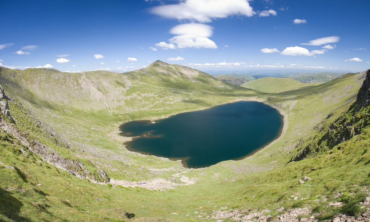
There is a moment, climbing up from Glenridding toward Helvellyn, when the path rises over a low rock step and Red Tarn comes suddenly into view. The water sits at 718 metres above sea level in a near-perfect glacial corrie, walled on three sides by the high crags of Helvellyn's eastern face. Striding Edge runs down one side. Swirral Edge runs down the other. Catstye Cam, the small pointed peak that looks like a child's drawing of a mountain, rises directly above. There is no other path to here. There is nothing here except the water, the wind, and a population of fish that has been holding on in this corrie since the last ice age.
Carved by Ice
Red Tarn is what geographers call a corrie tarn - a lake that fills the bowl left behind when a glacier melts. The glacier in question used to live here. It carved the eastern face of Helvellyn during the last ice age, then began to retreat about ten thousand years ago, then melted entirely. What remained was a deep depression at the head of the corrie, dammed at its lower end by moraine (rocky debris pushed downhill by the ice) and now filled with water. The tarn is twenty-five metres deep, which is remarkable for a body of water so small. The cold water at the bottom rarely warms much, even in summer. The high walls of the corrie keep direct sunlight off the surface for most of the day in winter. The whole arrangement is a textbook example of corrie formation - so textbook, in fact, that it appears in textbooks.
A Fish from the Ice Age
Red Tarn is one of only four lakes in Britain that still hold the Schelly, a small whitefish in the same family as the salmon. Schellies are relict populations - left behind in deep cold lakes when the climate warmed after the last ice age, isolated from one another, slowly evolving into a slightly different fish in each lake. They are rare, endangered, and intensely sensitive to changes in water chemistry. The Red Tarn population has hung on in this single high corrie for thousands of years. It cannot move. There is nowhere else for it to go. If the tarn warms or its water chemistry shifts - through runoff, acid rain, climate change - the population may simply disappear. The other three British populations are similarly precarious. The Schelly is one of those species whose continued existence is a function of patient luck.
A Victorian Dam
In the nineteenth century the Greenside lead mine, in the valley below at Glenridding, needed water to drive its machinery. The miners dammed the outflow of Red Tarn with boulders and raised the water level by eight or nine feet. The result was a hydroelectric reservoir, three miles up a steep mountainside, supplying power down to the dressing floors below. The dam is still visible if you look for it at the outflow. The mine closed in 1962. The tarn, which had been pressed into industrial service for a century, was allowed to find its own level again. Nature has reclaimed the small Victorian intervention almost entirely. Unless you know what you are looking at, the boulder dam reads as part of the natural landscape - which, given enough time, is what most human marks on the fells eventually become.
The Last Rest Stop
For walkers climbing Helvellyn from the east, Red Tarn is the natural last rest stop before the final ascent. The path from Glenridding climbs steadily up to Hole-in-the-Wall, then descends slightly to the tarn shore. Most walkers stop here for water and a sandwich before tackling either Striding Edge (south) or Swirral Edge (north) for the climb to the summit ridge. On a clear summer day there will be dozens of people on the tarn shore - dogs splashing in the shallows, walkers studying maps, the occasional wild swimmer in a thermal wetsuit. On a bad day there will be no one at all. The wind comes through the corrie from any direction, and the temperature can drop sharply when cloud crosses the sun. Mountain rescue teams know this tarn well. People have died near it. Most people, fortunately, simply eat a sandwich and walk on.
The Other Red Tarn
Confusingly, the Lake District has two tarns called Red Tarn. The smaller, less-visited one sits between Pike of Blisco and Cold Pike, west of the Langdale valleys, at a slightly lower elevation. It is a quieter spot - no Schelly, no Victorian dam, no walking-route fame. The Helvellyn Red Tarn is the famous one. The name is presumably ancient - perhaps a reference to iron-rich rocks turning the bed reddish-brown, perhaps an old colour term for the bracken on the surrounding slopes. The Lake District is full of names whose original meanings have been forgotten. Red Tarn keeps its name, its fish, its glacial bowl and its view of Striding Edge - and the walkers, season after season, keep arriving with their flasks of tea.
From the Air
Red Tarn sits at 54.528 degrees north, 3.009 degrees west, at 718 metres elevation in the corrie on Helvellyn's eastern flank. From the air the tarn reads as a small dark circular body of water surrounded on three sides by steep crags. Striding Edge descends south-east from the Helvellyn summit toward Patterdale; Swirral Edge descends north-east toward Catstye Cam. The tarn lies between these two ridges. Helvellyn summit (950 m) rises 230 metres directly west of the tarn. Glenridding lies in the valley to the east. Nearest airfields: Carlisle Lake District (EGNC) approximately 22 nm north-west, Newcastle (EGNT) about 55 nm east. Cruise altitudes of 5,500-7,000 feet provide safe terrain clearance. The corrie is often in cloud when the surrounding summits are clear, as cloud forms below the ridge tops in stable conditions.
Nearby Stories
- Parton railway station 4.4 km away
- Brough Castle 11 km away
- Cartmel Racecourse 13 km away
- Caerlaverock Castle 15 km away
- Vindolanda 18 km away
- Yorkshire Dales 25 km away
- Cashtal yn Ard 55 km away