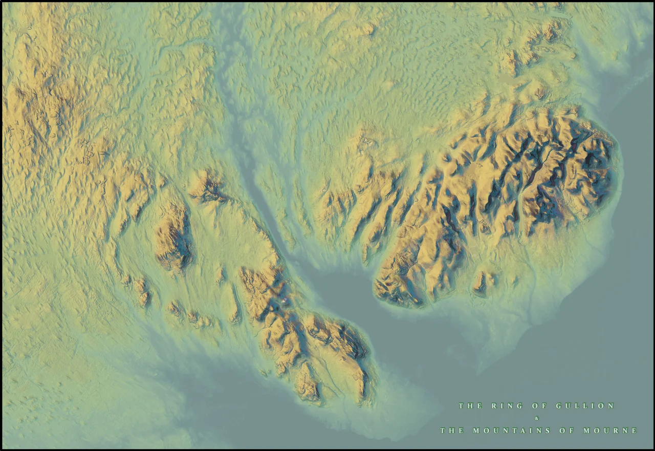

Ring of Gullion
Sixty-six million years ago - around the time the asteroid was falling toward Yucatan - a volcano was tearing open the crust of what would one day be South Armagh. As the Atlantic split open and Greenland began drifting away from Europe, magma rose along a circular fracture and a great composite caldera collapsed in on itself. What is left now, after the Ice Ages scoured everything else away, is a ring of hills enclosing a single rugged mountain at the centre. Geologists call it a ring dyke. The Ring of Gullion was the first one of these structures ever recognised on Earth, and the rocks here have been driving geological debate since the 1950s.
The First Ring Dyke
The Ring of Gullion is a roughly circular arrangement of hills enclosing about 150 square kilometres of County Armagh, with Slieve Gullion - the highest peak in the county at 573 metres - rising at its centre. The geology is genuinely peculiar. The outer rim is made of two concentric belts of granophyre and felsite - hard, igneous rocks that crystallised in the cracks left when an ancient caldera collapsed during the Paleogene, around 66 million years ago, as the Atlantic Ocean was opening and the North Atlantic Igneous Province was forming. Slieve Gullion itself, built later from layered igneous rock, formed inside that ring. The bedrock beneath Newry and the wider area is a Newry granite some 390 million years old, formed during the Silurian. So this landscape stacks four billion-year scales of time: an ancient seabed, an ancient granite, a Paleogene volcano, and an Ice Age glacial scouring.
Cailleach Beara's House
On the very summit of Slieve Gullion, beside a small dark lough that is the highest body of water on the island of Ireland, stands the South Cairn - a passage tomb that is the highest surviving Neolithic passage grave in Britain or Ireland. Locals call it Cailleach Beara's House, after the divine hag of Irish myth. The legend says that the sorceress Miluchra lured Fionn mac Cumhaill, the great Fianna warrior-hero, to the lough on the summit. He bathed in it and emerged an old, decrepit man. His Fianna companions broke the spell and restored him, but his hair never returned to its former colour. Folklore in the surrounding parishes still warns that bathing in the summit lough will turn your hair white. The cairn itself has stood there for around five thousand years, oriented so that the rising sun at the winter solstice penetrates the passage and illuminates the interior chamber.
The District of Poets
In the eighteenth century, when Irish-language literature was making its last great flowering before the Famine and the schools wore it down, the Ring of Gullion was known as Ceantar na bhFile - the District of Poets - or sometimes the District of Songs. The hills around Slieve Gullion produced an extraordinary concentration of Gaelic poets: Seamus Mor Mac Mhurchaidh, who was hanged at Armagh in 1750 and inspired one of the most famous laments in the language; Art Mac Cumhaigh, whose poem Uirchill an Chreagain remains a touchstone of Ulster Irish poetry; Peadar O Doirnin, the Forkhill schoolmaster whose love song Urchnoc Chein Mhic Cainte became a standard of the tradition. They worked in a landscape already heavy with story. The Tain Bo Cuailnge places Cu Chulainn's defence of Ulster at the Gap of the North, the Moyry Pass, on the southern edge of the Ring.
Six Thousand Years of Stones
People have lived in the Ring of Gullion for at least six thousand years. The hills are scattered with about twenty large stone tombs: the Clontygora Court Tomb, sometimes called the King's Ring; the Ballymacdermot Court Tomb, also superbly preserved; and Ballykeel Portal Tomb, a striking dolmen with a capstone tilted dramatically toward the sky. The Dorsey, on the western edge of the Ring, is an Iron Age earthwork built around 100 BC - two parallel banks and ditches more than a mile long, straddling an old route to Navan Fort, the ancient capital of Ulster. The Kilnasaggart Stone, near the southern border, is a 2.8-metre pillar with an inscription dating it to around 700 AD, possibly the oldest dateable carved stone monument in Ireland. The early Christian site at Killevy, at the foot of Slieve Gullion, was founded in the fifth century by St Monnina; pilgrims still visit her holy well on her feast day, 6 July.
A Cavern That Was Never Filled
By Camlough Lake - the Crooked Lake, largest in the Ring - sits a tunnel about a kilometre long, wide enough to drive an articulated truck into. It was cut into the mountainside in the 1960s for an ambitious pumped-hydro scheme. The plan was to hollow a great cavern inside Slieve Gullion, pump water up at off-peak hours and let it fall back to generate more than 200 megawatts of electricity when demand spiked. The Troubles arrived. The project was shelved. The tunnel sits there still, a Cold War-era piece of infrastructure abandoned to weather and ivy. Today the Slieve Gullion Forest Park, with its eight-mile scenic drive over the southern shoulder of the mountain, draws walkers up to the summit cairn and out across views of the Mourne Mountains, the Cooley Peninsula, and the gentle drumlin country of mid-Armagh.
From the Air
The Ring of Gullion is centred near 54.13 N, 6.43 W in southern County Armagh, Northern Ireland, just north of the border with the Republic. From the air the structure is unmistakable: a roughly circular ridge of hills about 11 km across, with the conical summit of Slieve Gullion rising from the middle. The Mourne Mountains lie about 25 km to the east, the Cooley Mountains 15 km south-east across Carlingford Lough, and the M1/A1 motorway runs along the eastern edge between Newry and Dundalk. Belfast International (EGAA) is about 55 km north; Dublin (EIDW) about 90 km south. The summit cairn at 573 metres is the highest point in County Armagh and on a clear day offers visibility from the Wicklow Mountains to the Sperrins.
Nearby Stories
- Cootehill 1.9 km away
- Mellifont Abbey 5.8 km away
- Tandragee 7.1 km away
- Oldcastle, County Meath 8.9 km away
- 1990 British Army Gazelle shootdown 11 km away
- Slieve Donard 15 km away
- Downpatrick and County Down Railway 17 km away
- German submarine U-1051 42 km away