Rollins Dam
When the water drops eighty feet in summer, the ghosts come back. Old roads surface from beneath Rollins Reservoir like lines on a draining map, and mine tunnels open their mouths along the Greenhorn banks -- remnants of the Gold Rush swallowed whole when the dam filled in 1965. One of those tunnels, the Numitor, was established by Warren Pierce in 1884. It sits now under sixty-six thousand acre-feet of water that irrigates farms, powers turbines, and fills the taps of Nevada and Placer counties. The reservoir exists because a country doctor saw what drought could do to people, and spent his life trying to fix it.
The Doctor's Crusade
Dr. Jarret Laben Rollins was a physician, but water consumed his public life. Practicing in the Sierra foothills, he watched farmers struggle with crops that withered and cattle that thinned because dry farming was unpredictable in this climate. He was also a prohibition leader, a man who believed in discipline over indulgence, and he brought that same moral conviction to the cause of water. Rollins helped establish the Bear River Water and Power Company, which laid the groundwork for what would become a regional water authority. In 1921, Nevada and Placer counties joined forces to create the Nevada Irrigation District, absorbing existing reservoirs, dams, and canals that dated back to the Gold Rush. Rollins championed the idea that water infrastructure was a public good, not a private commodity. He died of a heart attack in 1933, three decades before his vision would take its most dramatic physical form.
Rio de Oso
Spanish explorers named it Rio de Oso -- Bear River -- when they surveyed the area in 1822. By the 1860s, miners had transformed the valley. A state-operated fish hatchery stood where the Greenhorn end of the reservoir sits today, built by John Thorp and James Smith, evidence that even in the frenzy of the Gold Rush, someone thought about replenishing what was being taken. The Bear River carved its way down from the Sierra through a landscape riddled with mine shafts and narrow-gauge rail lines. The Nevada County Narrow Gauge Railroad's Bear River Bridge, an 810-foot-long, 196-foot-high trestle, had carried three hundred million dollars' worth of precious metals across the canyon. Its demolition during the dam's groundbreaking ceremony in the early 1960s was both a farewell to one era and the inauguration of another.
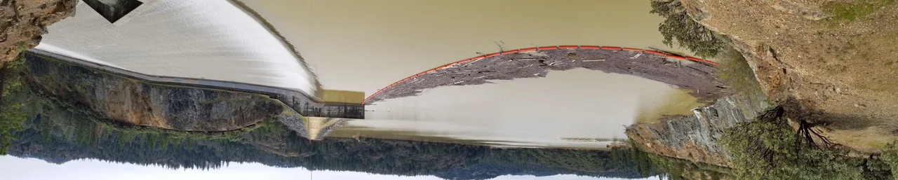
Building the Wall
Construction began in July 1963 under the direction of Ebasco Services, with Paul Hardeman, Inc. as general contractor. The project was part of the larger Yuba-Bear Hydroelectric Project, a sixty-five-million-dollar bond measure that voters approved in 1962 to bring flood control, water storage, hydroelectricity, and recreation to the region. By December 1965, the earthen dam stood 228 feet high and stretched 1,840 feet across its crest, impounding the Bear River and its tributary Steephollow Creek. In 1966, a dedication ceremony honored Dr. Rollins, who had died thirty-three years earlier. The Colfax records captured the ceremony's spirit: "A giant stride has been taken in providing facilities through which innumerable opportunities for economic development, recreation, and a richer life will open to the people of the region." Ernest "Ernie" Bierwagen, whose father had helped form the NID in the 1920s, oversaw the construction as a district director. He served twenty-five years in that role, often bringing his family to watch the reservoir take shape.
Mercury and Memory
The Gold Rush left more than tunnels beneath the water. Mercury, used to extract gold from ore, leached into the watershed and concentrated in the food chain. The Office of Environmental Health Hazard Assessment now limits fish consumption from the Northern Sierra Nevada Foothills: women and children under seventeen should eat no more than one bass and two channel catfish per month. The mines that built fortunes also left a chemical legacy that persists more than a century later. Meanwhile, the reservoir itself is slowly filling with something other than water. Studies found that roughly three thousand acre-feet of storage capacity have been lost to accumulated sediment and gravel over the decades since construction. The NID has worked to manage the buildup, but the river keeps delivering material from the same mountains the miners once carved open.
A Living Reservoir
Today Rollins Reservoir spreads across 1.3 square miles of the foothills, its power plant generating 12.15 megawatts that feed into the PG&E grid. Combined with the other NID facilities, the district produces about 375 million kilowatt-hours annually. But the reservoir's identity extends beyond infrastructure. Four campgrounds -- Greenhorn, Long Ravine, Orchard Springs, and Peninsula -- ring the shoreline with roughly 250 campsites. Greenhorn has a general store and an arcade. Families come for the Easter Egg Hunt and the NID Kids Triathlon. At the Orchard Springs campground, on the reservoir's west side, a plaque remembers Ernie Bierwagen: a man who "knew the importance of water to nature, the food supply, and the lives of all people." When the water is high, the reservoir looks timeless. When it drops in summer, the old roads and mine shafts remind visitors that this landscape has been shaped and reshaped by human ambition for nearly two centuries.
From the Air
Rollins Dam is located at 39.136N, 120.953W on the Bear River, straddling the border of Nevada and Placer counties in northern California. The reservoir's 1.3-square-mile water surface is clearly visible from altitude. Look for the earthen dam and the surrounding campgrounds along the shoreline. The reservoir sits southeast of Grass Valley and about 6 miles northeast of Colfax. Nearby airports include Nevada County Airport (KGOO) approximately 10 miles north-northwest and Auburn Municipal Airport (KAUN) about 18 miles south. Best viewed at 3,000-5,000 feet AGL. The reservoir's shape and the surrounding Sierra foothills terrain make it a useful navigation reference point.
Nearby Stories
- Sutter National Wildlife Refuge 10 km away
- The Lake That Swallowed a Gold Rush Town 13 km away
- Griffith Mansion 20 km away
- The Yuba County Five 34 km away
- Honey Run Covered Bridge 40 km away
- Western Pacific Railroad Museum 49 km away
- New Melones Dam 100 km away