The Ditch That Made Sacramento a Seaport
Sea lions have been spotted 80 miles from the Pacific Ocean, lounging at the eastern end of the Sacramento Deep Water Ship Channel where it meets the Sacramento River. American white pelicans fish the same waters. The animals are not lost. They followed a 43-mile canal that connects the Port of Sacramento in West Sacramento to the open river system draining into San Francisco Bay, a channel deep and wide enough for oceangoing cargo ships. Completed by the U.S. Army Corps of Engineers in 1963, this improbable waterway turned California's capital region into a seaport -- the kind of engineering audacity that defined mid-century America, and the kind of project whose afterlife has proved more complicated than its builders imagined.
Sixty-Four Years from Dream to Ship
The idea of connecting Sacramento to deep water predates the channel by decades. The River and Harbor Act of March 3, 1899, authorized a shallow-draft navigation project on the Sacramento River, and construction began that September. The modest project was completed in 1904, but it could not accommodate the large vessels that Sacramento's boosters envisioned. A proper deep-water channel was authorized by the River and Harbor Act of July 24, 1946, and construction began in 1949 -- only to halt in 1950 for reasons that have the flavor of postwar budget politics. Work did not resume until 1956. When the first ship finally transited the completed channel in June 1963, sixty-four years had passed since the original project broke ground. The finished canal measured roughly 30 feet deep and 200 feet wide, dimensions carefully calculated to handle the bulk carriers and general cargo vessels of the era.
Grain Ships and Quiet Piers
The Port of Sacramento never became a rival to Oakland or Long Beach. Tucked at the end of its long, narrow channel, it handles primarily agricultural products -- rice, wheat, and other bulk goods that the Sacramento Valley produces in abundance -- rather than the shipping containers that dominate modern global trade. The port is a significant facility on the West Coast, but it operates in a different register than the giant container terminals to the south, where cranes unload thousands of steel boxes from ships the size of aircraft carriers. Sacramento's piers are quieter. Ships arrive less frequently. The economics of deep-water shipping favor ports with direct ocean access, and 43 miles of canal maintenance is an ongoing expense. A plan to dredge the channel from 30 to 35 feet -- a depth that would accommodate larger modern vessels -- stalled in 1990 when the Port of Sacramento could not finance its share of the cost. Interest in the project persists, but the money has not followed.
Locks That No Longer Turn
At the channel's eastern end, where it meets the Sacramento River, sits the William G. Stone Sacramento Locks -- the only lock system on the entire waterway. Built to manage the difference in water level between the channel and the river, the locks were decommissioned in the mid-1980s and formally de-authorized by Congress in 2000. For two years in 2003 and 2004, they were briefly reactivated for a fish passage study, an echo of their original purpose repurposed for ecological research. Today the locks stand idle, their gates no longer cycling ships through. The decommissioning tells a quiet story about shifting priorities: the channel was built to move commerce, but the river system it connects to has become at least as important for water management, flood control, and habitat as it is for navigation.
A Green Corridor Through the Delta
The channel has found a second act as part of the California Green Trade Corridor, a project linking the ports of Oakland, Stockton, and West Sacramento into a marine highway intended to reduce truck traffic on Northern California's congested freeways. The concept is straightforward: move goods by barge on existing waterways instead of adding more diesel trucks to Interstate 80 and Interstate 5. Whether the corridor achieves its ambitions depends on the same question that has followed the channel since 1899 -- whether the economics of inland waterway shipping can compete with the convenience and speed of overland transport. For now, the channel remains what it has been for six decades: a long, straight cut through the delta, deep enough for ocean ships, quiet enough for pelicans, and just ambitious enough to keep people imagining what it could become.
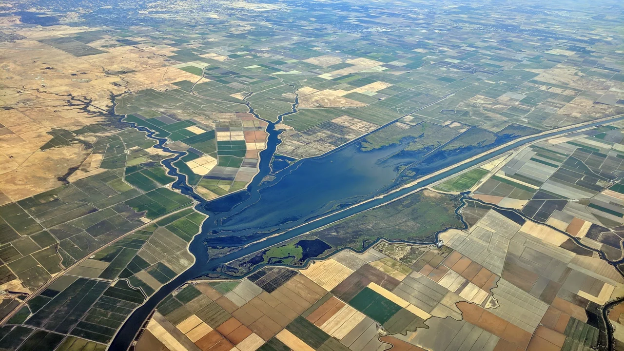
From the Air
The Sacramento Deep Water Ship Channel is clearly visible from the air as a straight, wide canal running roughly northwest-to-southeast through the Sacramento-San Joaquin River Delta, centered at approximately 38.13N, 121.70W. The channel connects the Port of West Sacramento (38.58N, 121.55W) to the Sacramento River. Look for the distinctive linear waterway cutting through the patchwork of delta farmland and levees. The William G. Stone Locks are visible at the eastern terminus where the channel meets the river. Recommended altitude: 2,000-4,000 feet AGL. Nearby airports: Sacramento Executive (KSAC) 6nm east, Sacramento International (KSMF) 15nm north, Rio Vista Municipal (O88) 10nm south.
Nearby Stories
- Pier 24 Photography 4 km away
- The Shallow Sea Between Four Counties 5.5 km away
- The Pathway Home 8.4 km away
- The Spinach Riot 8.6 km away
- The Roadside Stand That Fed a Queen 14 km away
- Rancho Seco Recreational Park 17 km away
- Niles Canyon Railway 23 km away
- From Aluminum to Ammunition to Aviation Fuel 34 km away