California's Holland
Half of California's water passes through a place most Californians have never seen. The Sacramento-San Joaquin River Delta sprawls across 1,100 square miles of Central California, a labyrinth of channels, sloughs, and sunken islands where the state's two longest rivers converge before draining into San Francisco Bay. From the air, it looks like a shattered mirror -- hundreds of irregular shapes bordered by thin lines of earth, the levees that keep the whole arrangement from reverting to the marsh it was ten thousand years ago. Those levees are all that separates some of California's richest farmland from the water that surrounds it on every side, and they are not as strong as the twenty-five million people who depend on this water might hope.
Born from Ice and Tide
The Delta owes its existence to a bottleneck. As the last Ice Age ended roughly ten thousand years ago, rising seas pushed saltwater inland through the narrow Carquinez Strait, the only outlet from California's vast Central Valley to San Pablo Bay and the Pacific beyond. Sediment carried down by the Sacramento River from the north and the San Joaquin River from the south piled up behind that narrow passage, unable to wash through fast enough. Tidal action compacted the deposits, and over millennia, a broad freshwater marsh emerged -- a tangle of shallow channels winding between low islands of peat and tule reed. The Miwok and Yokuts peoples navigated these waterways for thousands of years, fishing for salmon and gathering tule for boats and shelters. What they knew as a living wetland, the settlers who arrived in the 1850s saw as an obstacle to be conquered.
Draining the Labyrinth
Reclamation began almost immediately after the Gold Rush. Chinese laborers, many of whom had built the transcontinental railroad, were hired to construct the first levees by hand -- shoveling peat soil into berms that held back the water long enough for the land behind them to be farmed. By the early twentieth century, roughly 57 islands and tracts had been reclaimed, bordered by 1,100 miles of levees along 700 miles of waterways. The transformation was staggering in scale, but it carried a cost that only became apparent over decades. Peat soil, once drained, oxidizes and compresses. Wind strips it away. The islands that farmers had wrested from the marsh began to sink.
Today, much of the central Delta sits well below sea level -- some islands as much as twenty-five feet below the waterline of the channels that surround them. The nickname is earned: California's Holland. But unlike the Netherlands, which invested centuries and vast public resources in its flood defenses, the Delta's levees are largely maintained by local reclamation districts with limited budgets. Many levees are little more than heaped earth, vulnerable to earthquakes, floods, and the quiet daily erosion of time.
The Thirsty State's Lifeline
The Delta's importance extends far beyond the farms on its sinking islands. Massive pumping stations at the southern end of the Delta draw water into the California Aqueduct and the Delta-Mendota Canal, delivering it hundreds of miles south to irrigate the San Joaquin Valley and fill the taps of Southern California. More than half of the state's total runoff -- over thirty million acre-feet annually -- flows through the Delta's channels. This makes the region the single most critical node in California's water infrastructure, a fact that has fueled decades of political warfare between north and south.
The most contentious proposal has been the Peripheral Canal, first seriously debated in the 1960s and defeated by voters in 1982. The idea was to divert Sacramento River water around the Delta rather than through it, protecting the supply from levee failures and saltwater intrusion. Northern Californians viewed it as a water grab. Southern Californians viewed it as common sense. Variants of the plan have resurfaced repeatedly, most recently as a proposed tunnel, and the argument shows no sign of resolution.
An Ecosystem Under Siege
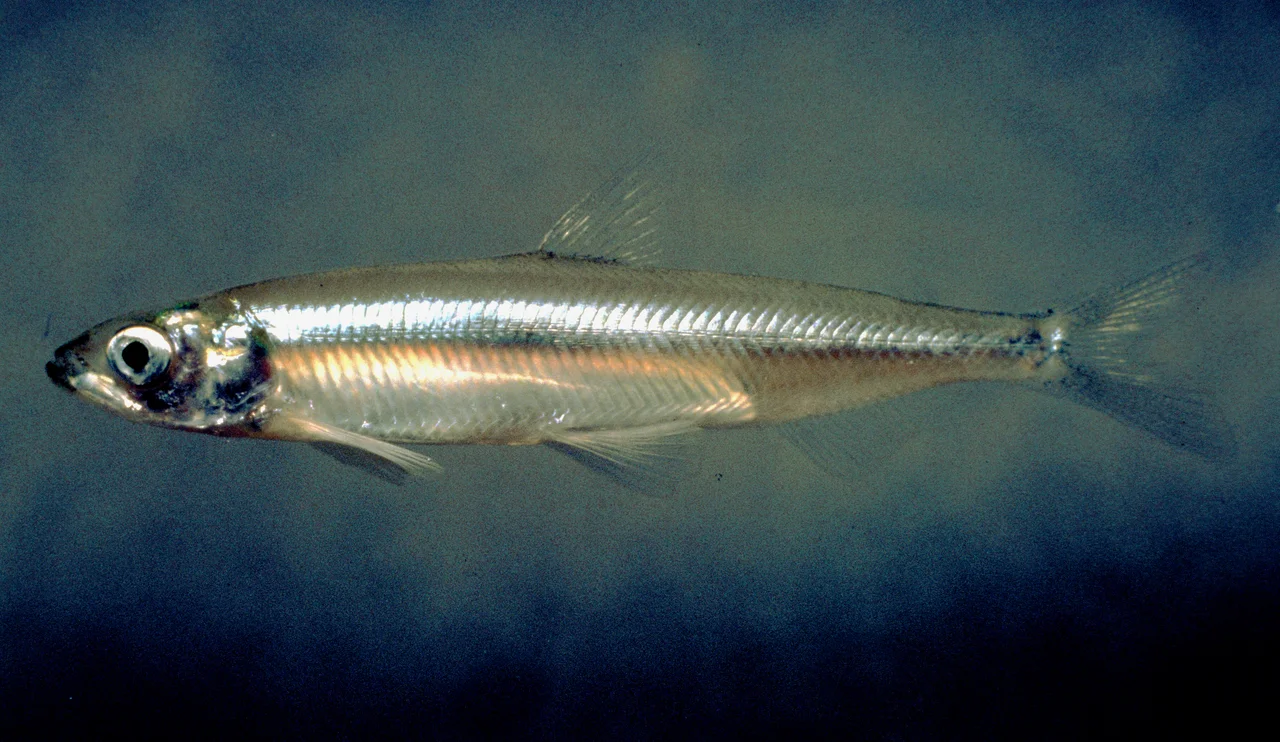
Before reclamation, the Delta teemed with life. Chinook salmon ran its channels, tule elk grazed its marshes, and enormous flocks of waterfowl darkened its skies during migration. Much of that abundance has been diminished. The delta smelt, a small translucent fish found nowhere else on Earth, has become the poster species for the Delta's ecological crisis -- its population collapsed so dramatically that pumping restrictions were imposed to protect what remained, triggering furious opposition from agricultural interests.
Pesticide runoff, invasive species, and altered water flows have compounded the damage. Toxic algal blooms now appear regularly in the warmer months. The nutria, a large South American rodent first detected in the Delta in 2017, threatens to burrow through levees already weakened by subsidence. In 2019, California designated the Delta a National Heritage Area, acknowledging its cultural and ecological significance. Whether that designation can translate into the sustained investment needed to preserve it remains an open question.
Living on Borrowed Time
The Delta exists in a state of engineered improbability. A major earthquake on any of several nearby faults could breach dozens of levees simultaneously, flooding islands in hours and drawing saltwater deep into the freshwater channels that supply millions of people. Geologists call this scenario not a question of if but when. Climate change amplifies the risk: rising sea levels push saltwater further inland, while more intense storms test levees that were never designed for the loads they now face.
Yet the Delta is also a place of strange beauty. Houseboats line the marinas of Discovery Bay and Bethel Island. Bass fishermen work the channels at dawn. The town of Locke, founded by Chinese immigrants in 1915, still stands along the Sacramento River -- one of the last rural Chinese towns in America. On quiet mornings, when the fog sits low on the water and the tule reeds catch the first light, the Delta looks almost exactly as it did before anyone thought to drain it. The difference is that now, the water is waiting.
From the Air
Centered at approximately 38.07N, 121.84W, the Delta sprawls across the confluence of the Sacramento and San Joaquin Rivers east of Suisun Bay. From 3,000-5,000 ft AGL, the network of channels, levees, and sunken islands is dramatically visible -- look for the geometric patchwork of agricultural land bounded by waterways. The Carquinez Strait marks the western outlet. Stockton Metropolitan Airport (KSCK) lies to the east, Rio Vista Municipal Airport (O88) sits on the northwest edge, and Buchanan Field (KCCR) is to the southwest. Sacramento Executive Airport (KSAC) is approximately 20 nm north. Best viewed in clear conditions when the contrast between water channels and farmland is sharpest.
Nearby Stories
- Pier 24 Photography 4 km away
- The Shallow Sea Between Four Counties 5.5 km away
- The Pathway Home 8.4 km away
- The Spinach Riot 8.6 km away
- The Roadside Stand That Fed a Queen 14 km away
- Rancho Seco Recreational Park 17 km away
- Niles Canyon Railway 23 km away
- From Aluminum to Ammunition to Aviation Fuel 34 km away