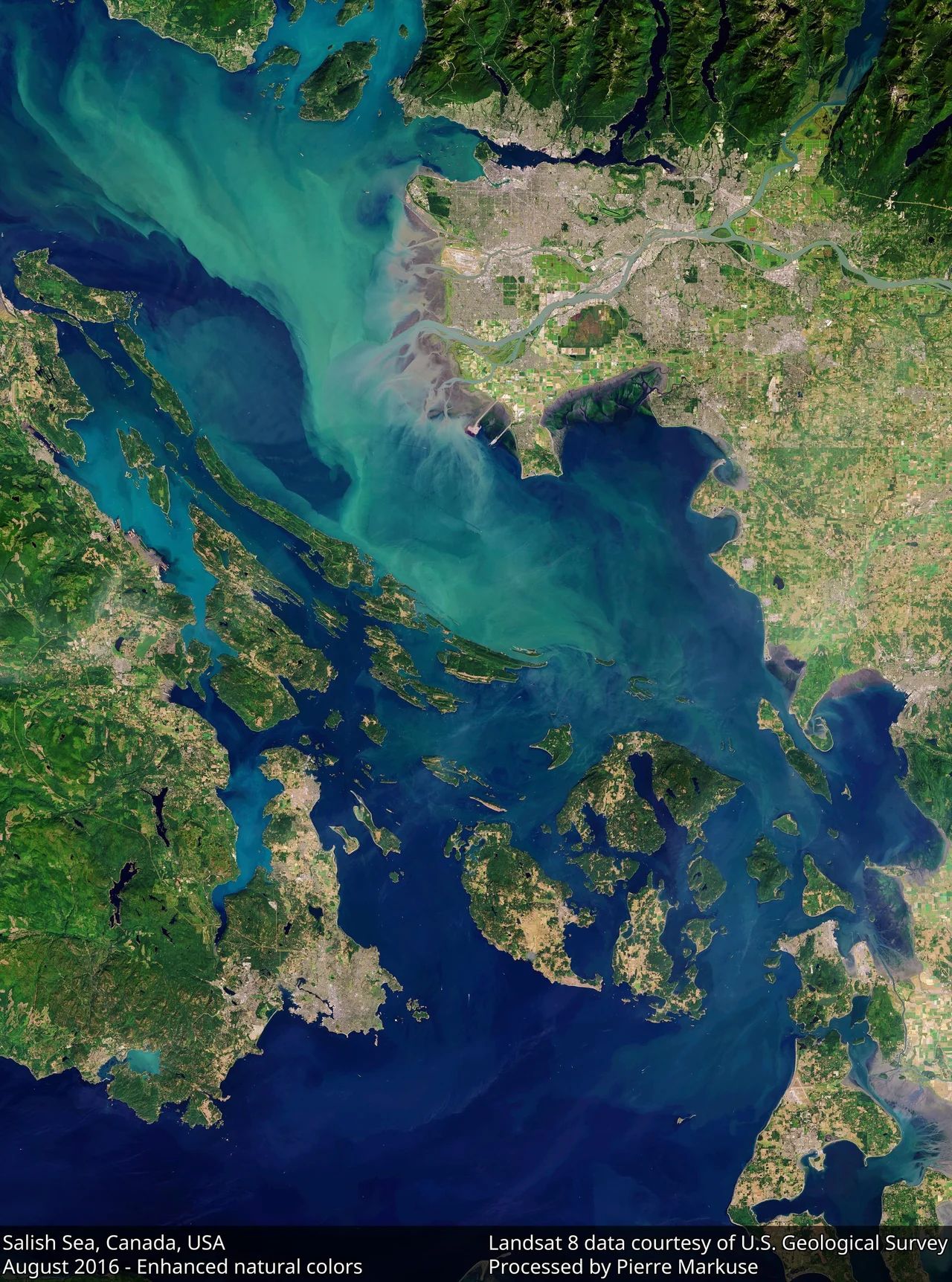

Salish Sea
The sea got its name in 1988, and it was one man's idea. Bert Webber, a geography professor at Western Washington University in Bellingham, was looking for a way to talk about a single body of water that maps had always carved into three: the Strait of Georgia, the Strait of Juan de Fuca, and Puget Sound. His proposal was not to replace those names but to add one above them, because the water does not recognise the boundary between them and neither does anything living in it. Call the whole thing the Salish Sea, he argued, and people might start caring for it as one place. It took two decades, but the name stuck: the United States Board on Geographic Names approved it on 12 November 2009, and British Columbia followed in February 2010.
Whose Name It Is
The name honours the Coast Salish peoples, who have lived along these shores for thousands of years and for whom these waterways were trade routes, travel corridors and a source of food they still depend on. There is an honest complication in it, though, which the record does not hide: no Coast Salish language has an overarching term for this whole body of water, or even a single shared name for any one of its parts. The Salish Sea is a modern name built from an old one, and the momentum for it came from both directions - in March 2008, the Chemainus First Nation proposed renaming the Strait of Georgia the Salish Sea, while an American campaign was pushing a broader definition covering all three basins. The basin is not exclusively Coast Salish territory either. It takes in Kwakwaka'wakw waters in the north and those of the Nuu-chah-nulth, Makah and Ditidaht toward the open Pacific, and it was once home to the Chimakum, a people related to the Quileute whose community did not survive the violence of the nineteenth century.
The Shape of the Water
Measured end to end, from the channels of the Discovery Islands in the north to the head of Budd Inlet at the far south of Puget Sound, the Salish Sea runs about 440 kilometres. Its surface covers roughly 18,000 square kilometres - about the size of the Gulf of Riga. It averages 130 metres deep and plunges to 670 metres in Jervis Inlet. Vancouver Island and the Olympic Peninsula shelter it from the open Pacific, leaving one main door at the western end of the Strait of Juan de Fuca. The land draining into it covers about 110,000 square kilometres, more than six times the sea's own area, and the Fraser River alone delivers an average of 3,475 cubic metres of fresh water every second, rising past 17,000 in flood. That flush matters: water sits in Puget Sound about 60 days on average before moving on, and in the Strait of Georgia about 160.
Carved and Drowned
The basin itself is old. The Georgia Depression formed out of a collision of continental plates roughly 150 million years ago, a long trough running parallel to the coast. What made it a sea was much more recent. During the Vashon Glaciation, between about 19,000 and 16,000 years ago, the Cordilleran Ice Sheet ground down the depression and scoured out its channels, and when the ice finally pulled back past what is now the Strait of Juan de Fuca, the ocean came in behind it. Everything above water is the leftovers: more than 400 islands, most belonging to one of three clusters - the Discovery Islands, the Gulf Islands and the San Juans. Whidbey Island is the largest and most populous, at 436.9 square kilometres.
Reefs That Should Not Exist
In 1987, surveyors working off the British Columbia coast found something that the textbooks said had been gone since the age of the dinosaurs: living glass sponge reefs. Sponges with skeletons of silica had built reef structures in shallow seas in the Mesozoic, and the assumption was that the practice died out during or shortly after the Cretaceous. It had not. The mineral-rich, cold water here suits them, and the reefs are still being built. Every known sponge reef in the Salish Sea is now closed to bottom-contact fishing, because a trawl dragged across one destroys in minutes what took centuries to grow. It is a fair emblem for the whole sea - something extraordinary that survived unnoticed, protected only after somebody finally looked.
Kelp, Whales and 8.76 Million People
Bull kelp and giant kelp form forests over the rocky bottom; eelgrass meadows carpet the shallows. Thirty-seven marine mammal species live here, among them Steller sea lions, humpback whales and killer whales, and the fortunes of the two orca populations have diverged sharply. Mammal-eating transients have been increasing. The fish-eating southern residents have not: with salmon runs depleted and a shrinking gene pool, the community stood at 73 whales in 2019, a 35-year low, after three adult deaths and three years without a surviving calf. Humpbacks have offered better news, with a record 21 calves counted in Salish waters in 2021. Of 172 bird species in the region, 72 depend directly on the marine ecosystem to feed. And the shoreline is not empty: anchored by Metro Vancouver and Metro Seattle, with Victoria, Nanaimo, Bellingham, Everett, Tacoma, Olympia, Bremerton, Port Angeles and Port Townsend between them, the Salish Sea basin was home to 8.76 million people as of 2021. Webber's point was that they all share one sea. They do.
From the Air
A representative mid-sea position is 48.9367 N, 123.0611 W, in the Strait of Georgia among the Gulf Islands near the Canada-United States boundary. The Salish Sea is best appreciated from altitude, where its three basins resolve into one system: the Strait of Juan de Fuca running west to the open Pacific between Vancouver Island and the Olympic Peninsula, Puget Sound reaching south past Seattle and Tacoma toward Olympia, and the Strait of Georgia running northwest toward the Discovery Islands, with the San Juan and Gulf Island archipelagos filling the junction between them. The brown plume of the Fraser River spreading into the strait south of Vancouver is visible for miles and is the single clearest marker of the sea's hydrology. Major fields ring the water: Vancouver International (CYVR), Victoria International (CYYJ), Bellingham (KBLI), Seattle-Tacoma (KSEA) and Naval Air Station Whidbey Island (KNUW), so expect dense controlled airspace, an international border, and heavy floatplane traffic between the islands and the cities. A viewing altitude of 8,000 to 12,000 feet MSL shows the whole basin arrangement on a clear day, with the Olympics to the southwest, Mount Baker northeast and the Coast Mountains behind Vancouver. Marine fog is routine in summer mornings and autumn; winter brings low cloud and strong outflow winds down the inlets.
Nearby Stories
- Turn Point Light Station 1.1 km away
- Musqueam First Nation 1.8 km away
- Pitt Meadows 1.8 km away
- Stz'uminus First Nation 4.5 km away
- Vendovi Island 11 km away
- Hovander Homestead Park 16 km away
- Canadian Forces Maritime Experimental and Test Ranges 19 km away
- Jordan River Dam 28 km away