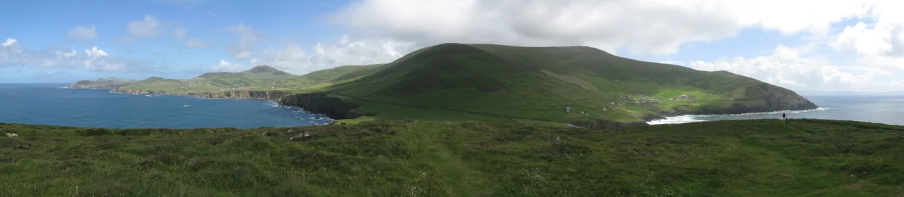

Slea Head
The land does not so much end at Slea Head as crumble into the Atlantic, a slow geological collapse 400 million years in the making. The cliffs here are made of pebbly sandstones and conglomerates from the Devonian period, the era when fish first crawled onto land — these rocks were ancient before the dinosaurs evolved. The headland sits on the southwest tip of the Dingle Peninsula, in the part of County Kerry where the road signs are in Irish first and English second, and the place names still belong to the people who named them. Slea Head, Ceann Sléibhe in Irish, looks west across an unbroken horizon of water. The next land is North America.
Old Red Sandstone
Geologists call the rocks here Old Red Sandstone, and the formation that makes up Slea Head and the southern slopes of Mount Eagle behind it is named for the headland itself: the Slea Head Formation. The rock dates to the Devonian period, roughly 419 to 359 million years ago, when this part of what is now Ireland sat near the equator and was part of a vast braided river system depositing pebbles and sand. You can still see the river-bed origin in the rock: rounded pebbles cemented into the cliff face, the strata tilted sharply where later mountain-building shoved them upward. Walking the cliff path, you are essentially walking on the petrified delta of a river that ran here when the first amphibians were learning to breathe air.
The Westernmost Edge
Slea Head is famous as a viewpoint, but it is not quite the westernmost point of the country. That distinction belongs to Dunmore Head, the promontory just to the northwest, which juts a little further into the Atlantic. From Slea Head you can see Dunmore Head to your right, and beyond it the Blasket Islands strung out across the sound — Great Blasket largest among them, then Inishtuaiscirt and Tearaght and the smaller stacks. Tearaght is in fact the most westerly land of the Republic of Ireland. On a clear day the view extends across all of them; on a foggy day, which is most days, the islands appear and disappear like things half-remembered.
The Wreck Visible from Above
Just below Slea Head, in the rocks near Coumeenoole Beach, the rusted bow of the MV Ranga still sits where it was driven aground in March 1982. The Spanish container ship lost engine power in an Atlantic storm on her maiden voyage and broke apart on the cliffs. All fifteen crew were rescued by breeches buoy and an RAF helicopter, but the ship itself could not be salvaged — the coast here is too inaccessible. Forty years of weather have flattened most of her, but the bow is still there, a small orange-red presence against the dark sandstone, visible from the cliff path. She is the most recent of dozens of wrecks along this coast, which has been chewing up ships at least since the Spanish Armada in 1588.
The Slea Head Drive
The R559 road that loops around the western end of the Dingle Peninsula is called the Slea Head Drive, and it is one of the great scenic routes of Western Europe. It passes Ventry Beach, a long curve of sand where in 1588 several Armada ships sheltered briefly before being scattered by storms. It passes Iron Age promontory forts and beehive huts where early Christian monks lived. It passes the Famine Cottage at Slea Head itself — a restored 19th-century farmhouse showing how a family lived through the Great Famine. And it passes the Gallarus Oratory, a thousand-year-old corbelled stone chapel still watertight, a single small room shaped like an upside-down boat. The road is narrow, often single-track, and the drivers honk at every blind corner. The road ends back at Dingle town, and the loop closes.
From the Air
Coordinates 52.1062°N, 10.4692°W, the westernmost promontory of the Dingle Peninsula. Cliffs rise approximately 60 m above the Atlantic, with Mount Eagle (516 m) just inland to the northeast. Best viewed at 2,000–4,000 ft AGL; the view extends west to the Blasket Islands. Dunmore Head — the actual westernmost point of mainland Ireland — lies immediately to the northwest. Kerry Airport (EIKY) is approximately 55 km east. Weather is highly variable: clear mornings can give way to low cloud and rain within an hour.
Nearby Stories
- Ballyheigue Castle 1 km away
- Killemlagh Church 2.8 km away
- Pouldergaderry Sinkhole 6.8 km away
- Derreen Garden 11 km away
- Kilkee 59 km away
- The Laki Eruption: The Volcano That Changed World History 1366 km away
- The Northern Lights: The Sky Show That Vikings Thought Was Bridge to the Gods 1469 km away
- Sao Miguel 1935 km away