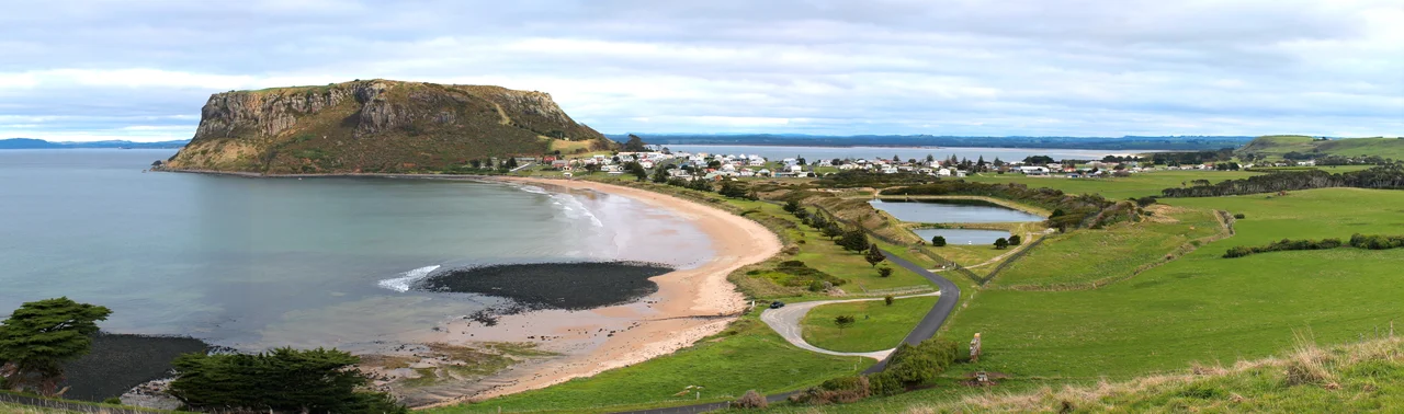

Stanley (Tasmania)
Sailors once called it Circular Head, and from the deck of a ship the name made perfect sense: a great rounded mass of rock rising sheer from the sea, flat on top, impossible to miss. Locals just call it The Nut. The 143-metre plug is the throat of a volcano that went quiet some twelve million years ago, and the softer land around it has long since worn away, leaving the hard basalt core standing alone above the water. The little town of Stanley shelters in its shadow, a cluster of weatherboard cottages and fishing sheds at the very tip of Tasmania's northwest, where roughly 500 people live with one of the island's strangest landmarks filling the end of nearly every view.
The Rock That Refused to Erode
The Nut is what geologists call a volcanic plug. When the volcano stopped erupting, lava cooled and hardened inside its vent into a dense column of basalt. Over millions of years, wind and waves stripped away everything softer, and the plug was left behind like a stopper in a long-emptied bottle. Its flanks rise almost vertically on every side, ringed by a flat plateau at the summit and a fringe of rocky coast below. There are two ways up. A chairlift climbs roughly 95 metres over a few hundred metres of cable, depositing visitors at the top in about five minutes, and a steep zig-zag walking track switchbacks up the slope for those who prefer to earn the view. From the plateau, a circuit track loops the rim, opening onto Bass Strait, the patchwork farmland of the hinterland, and the long grey curve of the coast.
A Town at the End of the Road
Stanley does not happen by accident. There is only one way in, and it is by car, down the B21 from the Bass Highway. The nearest town of any size is Burnie, a little over an hour away if you drive straight through, though almost nobody does. The road there threads past beaches, capes, and bluffs that locals have branded the Great Nature Trail, and the temptation to stop is constant. That isolation has preserved something. The streetscape still reads as a nineteenth-century port: low cottages, a working harbour, the smell of salt and diesel and bait. The town wears its remoteness as character rather than hardship, a place that feels held apart from the rush of the mainland by the width of a notoriously rough strait.
Doorway to the Tarkine
Stanley is also a threshold. Just inland and to the south lie the Tarkine forests, one of the largest tracts of cool-temperate rainforest left in the Southern Hemisphere, a green wilderness of myrtle and sassafras and rivers the colour of strong tea. Follow the coast west and you reach a stretch the locals call the Edge of the World, where the next landfall due west is Argentina and the wind has crossed thousands of kilometres of open ocean to get there. Few small towns sit so close to so much wildness. From a single base of a few hundred people, you can stand beneath an extinct volcano in the morning and walk into ancient rainforest by afternoon, the two landscapes separated by only a short drive.
Life Beneath the Plug
Living in the lee of a landmark shapes a place. The Nut is not scenery that Stanley visits; it is the wall at the back of the town, the thing the morning light hits first and the evening light leaves last. Fishing boats still work out of the harbour below it, hauling in the catch that has sustained the village for generations, and the chairlift hums up and down its flank carrying visitors who come precisely because there is nothing else quite like it. Seabirds wheel around the summit, and short-tailed shearwaters, the muttonbirds of these latitudes, burrow into the slopes. For a town this small and this far from anywhere, The Nut is more than a curiosity of geology. It is an anchor, a clock, and a constant companion, the reason a few hundred people have chosen to stay at the very edge of an island at the edge of the world.
From the Air
Stanley sits at 40.77 degrees south, 145.30 degrees east, on a small peninsula at the far northwest tip of Tasmania. The Nut is the unmistakable navigation marker: a sheer-sided, flat-topped basalt plug 143 metres high, jutting into Bass Strait and visible for many kilometres in clear conditions. The nearest aerodrome is Smithton (YSMR), a short distance west, with Burnie's Wynyard Airport (YWYY) about 60 km east-southeast along the coast. Skies here can change quickly; westerly winds off the strait bring fast-moving cloud and frequent showers, so plan for shifting visibility over the coast.
Nearby Stories
- Cape Grim Massacre 13 km away
- Bass Strait 49 km away
- Mount Bischoff 53 km away
- Overland Track 76 km away
- Cataraqui 93 km away
- Beaconsfield Mine Collapse 96 km away
- The Valentich Disappearance: 'It Is Not an Aircraft' 130 km away
- Chatham Islands 3167 km away