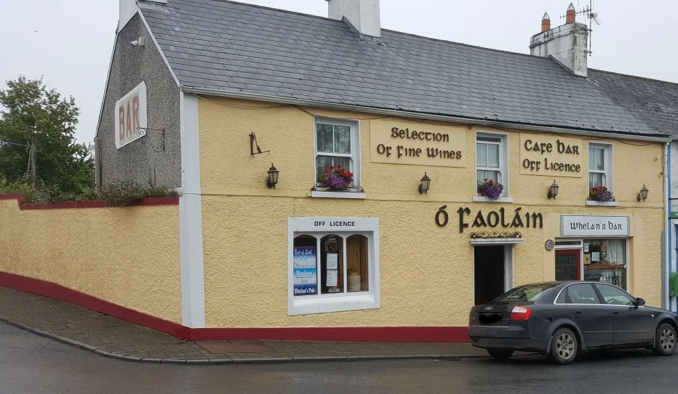

Stradbally, County Waterford
Stradbally was designed. Most Irish villages weren't - they grew up around crossroads and chapels and ferry crossings, accreting the way a coral reef does. But the Stradbally you see today was laid out at the end of the 18th century by the Uniacke family of nearby Woodhouse, who owned the village and most of the surrounding land. The market square at the centre, the terraced two-storey houses around it, the dominant three-storey ex-police barracks on the east side - all of it was put there on purpose. What the planners did not anticipate is how strange the village would become at certain edges: a 13th-century church ruin behind the new one, a gravestone nobody can quite explain, and one Christmas morning in 1929 when a postman walked out and never came back.
The Uniacke Village
The present village sits in a civil parish of the same name, six kilometres inland from a small cove at the mouth of the River Tay. Its Irish name, An Sráidbhaile, means simply 'the street town' - the kind of name you give to a planned place, where everything is on one street. The Uniacke family's school sat down on the riverbank at the entrance to Stradbally Cove; a painting of it survives in the National Library, and the building, now called Cove Lodge, still stands. Around the village in the early 19th century the Barron family added their own civic touches: in 1806 the Catholic landowner Pierce Barron opened a school 'for the gratuitous education of the poor of the parish,' a single building divided in two halves so boys could be taught at one end and girls at the other. It served as a boys' school for 160 years and is now the community hall.
Two Churches and the Sisters of Mercy
St James' Church of Ireland was begun in 1798 when John Devereux arrived as vicar; the main body was finished in 1802, the tower in 1806. The Holy Cross Catholic church, just outside the village, went up in 1834, the stained glass following in 1868, the tower in 1870, the apse in 1873 - all funded largely by the Barrons. In 1875 the parish priest Fr Thomas Casey invited the Sisters of Mercy to come. They started in Myrtle Lodge, then took over what had been Hannigan's Hotel on the square (now Whelan's pub), and finally settled into the old parochial house behind Holy Cross, which they renamed Mount St Joseph's. They built a school there that opened in 1890 and ran a small linen industry to give local girls employment - it lasted thirty years before cheap imports closed it down in 1925. The convent itself closed in 1988, but the school carries on as St James' National School.
The Ruined Church
Walk up Church Lane past St James' and you find the older church standing just behind it - or what remains. The medieval ruin's nave dates from about 1215 and measures over 17 metres long. Two doorways pierce the side walls; draw-bar sockets either side of the north door tell you that in dangerous times the bar was hauled across and the building barricaded. A sandstone stoup just inside the south doorway still holds the indentation worn by centuries of fingers in holy water. The west gable once carried a bell-cot - it was still there when John O'Donovan recorded the Ordnance Survey visit in 1841 - and the three-storey tower probably dated to the 13th or 14th century. The most curious thing about the church is what visitors often assume about it: that it was an Augustinian abbey. It was not. The mistake comes from the fact that for over three hundred years the church and its lands belonged to the Augustinian Priory of Inistioge in County Kilkenny - both having been founded by the same Anglo-Norman lord, Thomas fitz Anthony.
Who Was Ysabella?
Inside the nave lies an inscribed stone that nobody has ever fully translated. The surviving portion of the inscription reads YSABELLA GAL... JACET PLNI. The top of the stone carries a small lily - symbol of the Resurrection - and the all-seeing eye, alongside other symbols whose Christian meaning is at least guessable. The stone probably dates from around 1600, when the church was still being used; in 1615 a visitor described it as dilapidated, and the oldest dated gravestone in the yard, that of one Michael Martin, is from 1717 with the skull-and-crossbones of his era. Nobody knows how the Ysabella stone ended up here. Locals have guessed she was a Galvin or a Galwey - both common Waterford names - but one 19th-century scholar argued that if the inscription were complete it would actually read 'Beneath this altar lie the remains of Blessed Paulinus.' Either way, somebody once mattered enough that the work of carving was done. The name and the story have both gone missing.
The Postman Who Vanished
On Christmas Day 1929, the village postman Larry Griffin disappeared. He had finished his rounds and stopped in for drinks; sometime after that he was gone. Several residents were arrested and charged with his murder, but the case fell apart at trial and all were acquitted. His body was never found. Almost a century later, the case remains officially unsolved and locally undiscussed. Stradbally has gone on with the steadier things. The GAA club, founded in 1886, won five Waterford senior football titles in a row from 1940 to 1944 and again from 2001 to 2005 - a rare achievement for any rural club. There is a handball alley on Chapel Road from 1934. The market square fills on a summer evening with people whose grandparents may well have known what happened to Larry Griffin, and have taken it with them.
From the Air
Stradbally sits at 52.13°N, 7.46°W on the south coast of County Waterford, about 6 km inland from the Celtic Sea. The village lies on the small River Tay, with Stradbally Cove at its mouth. The N25 Cork-Waterford road passes a few kilometres to the north. From the air, look for the planned market-square layout - unusual among Irish villages - and the twin churches at the western edge with the medieval ruin between them. Nearest airports: Waterford (EIWF) about 25 km east-north-east, Cork (EICK) about 100 km west-south-west, Shannon (EINN) about 165 km north-west.
Nearby Stories
- Kilcash Castle 3 km away
- Hook Lighthouse 7 km away
- Aghada 9.3 km away
- Tipperary (town) 11 km away
- Fermoy 13 km away
- County Wexford 28 km away
- Ballycotton Lighthouse 29 km away
- Skomer 120 km away