
Sudetenland
The word is younger than most of the buildings it describes. Sudetenland is a compound - Sudeten, the mountain chain along the northern Czech border, plus Land, country - and it came into general use only in the early 20th century, after 1918. No territory of that name had ever existed as a unit of anything. The German-speaking districts it was meant to cover were not one region but three separate rims of Bohemia, Moravia and Czech Silesia, running north, west and south, most of them nowhere near the Sudeten mountains. The term did work no map could do: it made a scatter of valleys into a place. A place can be claimed.
Seven Centuries of Being There
German-speaking settlers came into the thinly populated Bohemian border country from the 13th century, invited by the Přemyslid kings - Ottokar II and Wenceslaus II above all. They cleared hillsides and built glassworks in the forests, which is why this frontier still makes glass. Both language groups endured the same catastrophes: the Thirty Years' War cost Bohemia around seventy percent of its population. From 1627 the Habsburgs' Renewed Land's Constitution steadily raised German into the language of administration and pushed Czech into second place. Only in the 19th century, with František Palacký's Austroslavism on one side and Pan-Germanism on the other, did neighbours become nationalities. The census of February 1921 counted 3,123,000 native German speakers in Czechoslovakia - 23.4 percent of the country.
Nineteen Eighteen
When Austria-Hungary fell apart, both peoples reached for the same American argument. Czechoslovakia was proclaimed in late October 1918; within days the German deputies of Bohemia, Moravia and Silesia invoked Wilson's Fourteen Points and declared four units of their own - the Province of German Bohemia at Reichenberg, now Liberec; the Province of the Sudetenland at Troppau, now Opava; the Bohemian Forest Region; and German South Moravia. Wilson's envoy Archibald Coolidge came back arguing for German self-determination almost everywhere he had been, but Paris kept the Czech lands whole, and the Treaty of Saint-Germain confirmed it in 1919. The picture on the ground was never a bloc: glass and textile firms in the border hills sold into Bohemia and feared competition from the Reich, and Silesian Germans preferred Prague to Warsaw.
The Glassworks and the Party
The Depression hit these districts harder than the interior, because of what they made. Sixty percent of Czechoslovakia's glass and costume-jewellery industry sat in the border regions, sixty-nine percent of its workers spoke German as a first language, and ninety-five percent of the jewellery went abroad. When export markets closed, entire valleys stopped working. Add the pushing of Czech into schools and public offices, and Konrad Henlein's Sudeten German Party found its audience. The movement was not one thing. Contemporary reporting found large numbers who actively opposed annexation, and by one estimate more than half of Henlein's own supporters wanted autonomy inside Czechoslovakia rather than a moved border; some of his own negotiators did not know what he had already agreed with Hitler. In April 1938 the party issued eight demands for full equality with Czechs. The government accepted them on 30 June. It changed nothing.
Munich, and the Gau
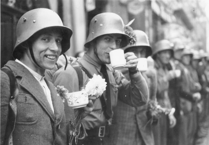
Chamberlain met Hitler at Berchtesgaden on 15 September 1938 and conceded the cession; Daladier followed three days later. No Czechoslovak representative was invited to any of it. At Godesberg on 22 September he raised his price; at the Sportpalast he called the Sudetenland "the last territorial demand I have to make in Europe," with a deadline of two o'clock on 28 September. The Munich Agreement was signed on the 29th by four men, none of them Czech or Slovak; the Czechoslovak government submitted the next day. The districts were handed over between 1 and 10 October; Poland took a piece with a Polish majority. On 1 May 1939 the northern and western parts became Reichsgau Sudetenland with Reichenberg as capital and Henlein as governor. In December 1938, 97.32 percent of the electorate there voted for the Nazi party; roughly half a million eventually joined it, 17.34 percent of the German population against a Reich-wide average of 7.85. Because they spoke Czech, many went on to staff the occupation administration and its police.
Emptied
What that produced fell first on other people. Synagogues burned in November 1938 and Jewish community leaders were sent to concentration camps. Czechs were driven from the annexed districts; German socialists, communists and pacifists were hunted too. Then 1945 reversed everything, and fell on people who had had no vote in any of it. Prague banned the word Sudety, replacing it with pohraniční území, border territory. Potsdam agreed the Germans would go. The first months, that spring and summer, ran ahead of any law: up to 800,000 were driven out amid reprisals, before any decree governed the process. By 1950 a population of 3,149,820 in 1930 had fallen to 159,938, and most of those permitted to stay as proven anti-Nazis were later dispersed inland. Czechs moved in, and with them Slovaks, Roma, Carpathian Ruthenians, Jewish survivors and Greeks fleeing their own civil war. Much of the high ground was never refilled: a forbidden zone two kilometres deep allowed no civilians on the border at all, and the Aš Bulge lived inside that regime until 1989. In the 2021 census, 24,632 people in the Czech Republic claimed German ethnicity. The old Bohemian dialects are effectively gone. The word was invented to make one region out of many districts; it worked, and then the region it named was emptied of the people it was invented for.
From the Air
The Sudetenland was never a single place, so this marker sits at 50.717 N, 15.067 E, just south of Liberec - Reichenberg, the capital of Reichsgau Sudetenland from 1939 to 1945 - which is as close to a centre as the term ever had. What it actually described is the entire mountainous rim of the Czech lands: the Ore Mountains along the Saxon border, the Lusatian, Jizera and Giant Mountains to the north and northeast, the Silesian border ranges to the east, and Šumava, the Bohemian Forest, running southwest along the Bavarian and Austrian frontier. Fly the rim between 4,000 and 8,000 feet and the history is legible from the air: a near-continuous forested arc around the Bohemian basin, with noticeably fewer villages than the interior, large unbroken blocks of woodland where settlements were cleared and never replaced, and isolated church towers standing in open ground. Terrain along the rim runs from roughly 1,000 to 1,600 metres, so plan minimum safe altitudes and expect ridge turbulence and rapid cloud build-up. Prague (LKPR) sits in the middle of the basin the rim encloses; Dresden (EDDC) lies just beyond the northwestern edge and Wrocław (EPWR) beyond the northeastern one. The border valleys hold fog and winter inversions for days at a time.
Nearby Stories
- JAT Flight 367 12 km away
- Herrnhut 15 km away
- Pillnitz Castle 38 km away
- The Defenestration of Prague: The Thrown Men Who Started a Thirty Years' War 40 km away
- Krzeszow Abbey 42 km away
- Lubiaz Abbey 77 km away
- The Battle of Vienna: The Cavalry Charge That Saved a Continent 254 km away
- 2020 Vienna Attack 270 km away