Sweetwater Dam
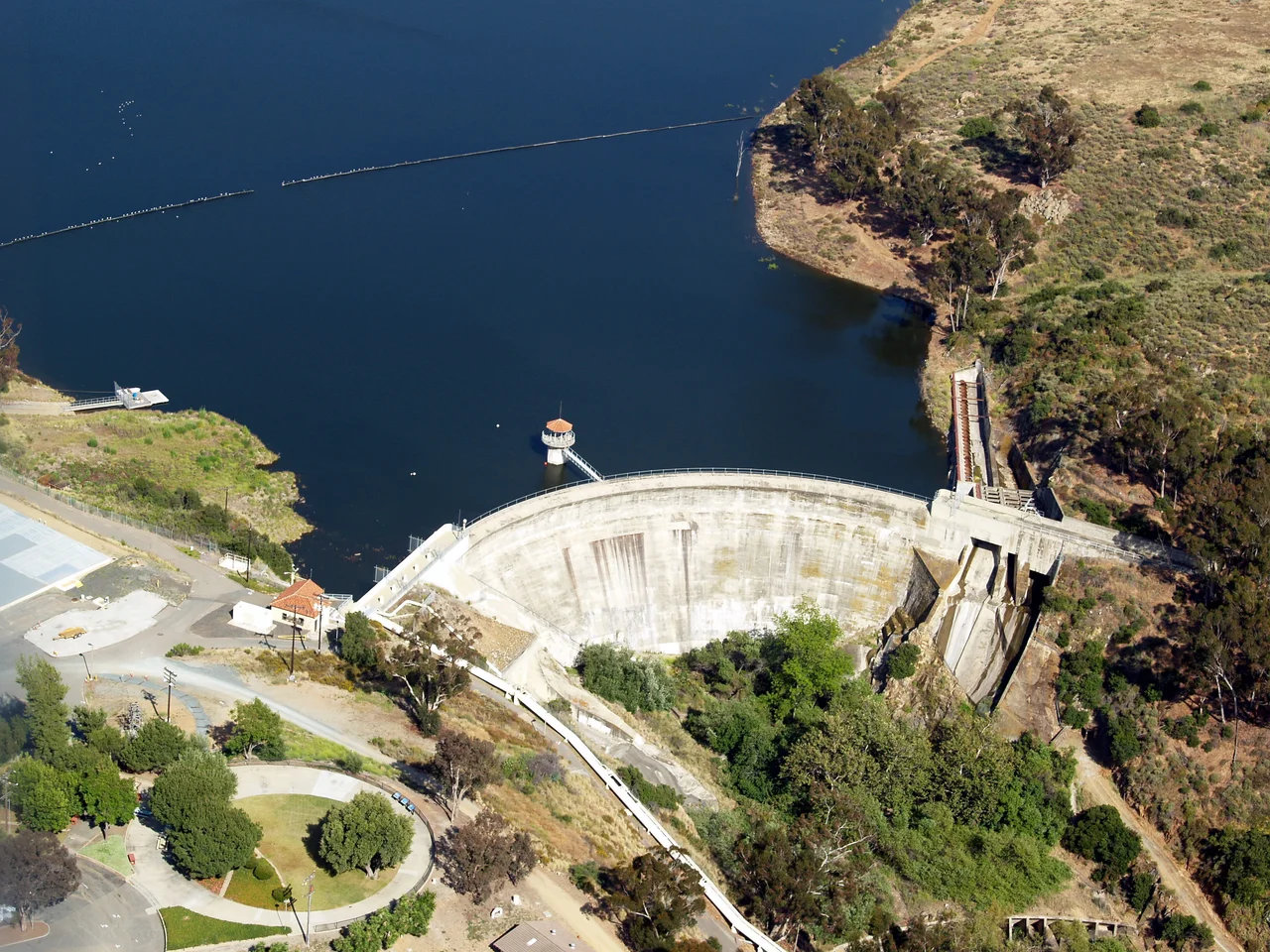
Built in 1888 on the Sweetwater River southeast of San Diego, Sweetwater Dam was once the tallest masonry arch dam in the United States — a 90-foot engineering marvel that survived a catastrophic flood only to be tested again three decades later.
The Highest Dam in America
In the late nineteenth century, Southern California was growing faster than its water supply. Engineers and civic boosters alike understood that whoever could capture and store the region's scarce rainfall would shape the future of entire communities. The Sweetwater Dam, completed in 1888 at a cost of $234,074.11, was their answer.
At 90 feet high, it was the tallest masonry arch dam in the United States at the time of its construction. Built across the Sweetwater River in what is now Bonita, just southeast of San Diego, the dam held back enough water to serve the growing towns of National City and Chula Vista. Engineers from around the country came to study it. For a region that had gambled its future on water, the dam was more than infrastructure — it was proof that the dry land could be made to bloom.
The Night the River Came Down
Even before the dam was completed, floods had shown what the Sweetwater River could do in its worst moods. But in 1916 the river did something worse.
A series of storms in early 1916 sent catastrophic amounts of water downstream. The dam's arch held — the engineering was sound — but the flood waters found a different path, eroding and destroying both abutments on either side of the dam's base. The structure itself survived while the ground around it gave way.
Repairs were undertaken. The dam was reinforced. It continued to serve the region for decades, though its title as America's tallest masonry arch dam had long since passed to newer, larger structures built in an era of concrete and steel rather than cut stone.
A Landmark Hidden in Plain Sight
Today Sweetwater Dam sits within Sweetwater Summit Regional Park, a quiet preserve of chaparral and canyons where hikers pass the old masonry structure without always knowing what they're looking at. The dam is no longer in active use for primary water supply — the region's water infrastructure has grown enormously — but it endures as a historic artifact.
In 2006, the American Society of Civil Engineers designated Sweetwater Dam a Historic Civil Engineering Landmark, placing it in the same category as the Brooklyn Bridge and the Hoover Dam — monuments to what nineteenth-century engineers accomplished with stone, mortar, and ambition. The designation recognized not just the dam's size at the time of completion, but its survival: a structure built before the automobile was invented that still stands in recognizable form.
Water and the Making of Southern California
The Sweetwater Dam story is, at its core, a story about water — and about how much of Southern California's history is inseparable from the question of where water comes from and who controls it.
The communities that grew around Sweetwater Reservoir — National City, Chula Vista, the South Bay — exist in the form they do partly because the dam made agricultural and domestic water available where it otherwise would not have been. The same dynamic would play out at larger scale across the American West, as dams and aqueducts reshaped what was possible in dry lands.
Sweetwater was one of the earliest chapters in that story. Its 90-foot arch of cut stone, rising above a river that was mostly dry for much of the year, was an act of faith that the land could sustain a civilization — and for over a century now, that faith has been tested and found, more or less, to hold.
From the Air
Sweetwater Dam is located about 12 miles southeast of KSAN (San Diego International Airport), near the community of Bonita. Flying south from San Diego, the Sweetwater Reservoir is visible as a narrow blue ribbon set in the dry chaparral hills east of Chula Vista. The dam itself sits at the reservoir's southern end and is most visible on approaches from the east. The US-Mexico border lies roughly 10 miles to the south.
Nearby Stories
- John William Finn 4.8 km away
- San Vicente Dam 5.3 km away
- Vallecito 12 km away
- Spanish Missions in Baja California 15 km away
- Mission Basilica San Juan Capistrano 74 km away
- San Clemente Island 106 km away
- Off-roading in Baja 187 km away
- Guadalupe Island Biosphere Reserve 375 km away