Tete, Mozambique
In the Nyungwe language, Tete means reed - for the tall stands that line the banks of the Zambezi where the town sits, 260 miles inland from the Indian Ocean. The name is older than almost anything else in the city. It predates the Portuguese who arrived in 1531, and the Swahili traders who were here long before that, and the bridges, and the coal trains, and the long slow traffic jams that now stretch along the highway on hot afternoons. Rivers wear down around persistent things, and the reeds remain. Tete has watched five centuries of traders, soldiers, and engineers come and go, and it is still the largest city on the Zambezi - still the town that controls the river's middle crossings.
Chasing the Kingdom in the Hills
The Portuguese came to the Zambezi hunting a rumor. Somewhere up this river, they had been told, lived the Munhumutapa - a ruler whose kingdom in the hills south of the river was supposed to be rich beyond counting in gold. The stories were not entirely wrong; the Mwenemutapa realm did trade in gold, and its mines had been supplying the Indian Ocean coast for centuries. In 1531, driven by these stories, the Portuguese established two settlements far up the Zambezi. One of them was Tete. The new arrivals found themselves not in an unclaimed wilderness but in a landscape already organized by African traders from the Swahili coast, who had been moving ivory, gold, and copper through these bush corridors for generations. The two commercial networks overlapped uneasily, then collided. In 1561, at the Munhumutapa capital, Muslim advisers convinced the king to kill the Jesuit missionary Gonçalo da Silveira. The Portuguese retaliation came seven years later - a campaign of 1,000 men launched upriver in 1568 that ended the Swahili commercial presence at Tete.
Market of Ivory and Gold
What the Portuguese could not do was reach the gold itself. The Mwenemutapa kingdom remained largely autonomous in its hill country, trading with whomever it chose, holding the mines at a distance from the European newcomers. But Tete, positioned where the river narrowed enough to ferry safely, became the Portuguese market town for whatever came down from the interior - ivory from elephant hunts across the highlands, gold dust traded through middlemen, captive people moved through a traffic that would outlast the centuries. By the mid-17th century Tete had established itself as the regional entrepôt. It received a Portuguese town charter in 1761, and in 1959, in the last gasp of empire, it was formally declared a city of the Portuguese Overseas Province of Mozambique. That empire collapsed in 1974, when the Carnation Revolution in Lisbon ended the Portuguese Colonial War. Independent Mozambique arrived in 1975, and within two years the country fell into a civil war that ran until 1992.
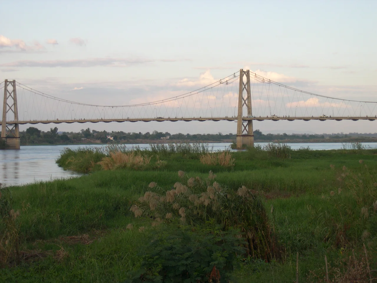
Two Bridges Across the Zambezi
Geography is destiny along a river this wide. The Zambezi at Tete is nearly a kilometer across in the dry season and much more when the rains come. For most of Tete's history, crossing required a ferry. That changed in 1973, when Portuguese engineers under Edgar Cardoso finished the one-kilometer Samora Machel Bridge on the eve of decolonization. It was an extraordinary piece of work - a suspension span that linked northern and southern Mozambique and gave trucks from Zimbabwe and Malawi a direct route to the sea. For more than four decades it carried essentially all of that traffic, becoming the signature choke point of Tete's daily life. In late 2014 a second bridge opened south of the city, routing through-traffic around the provincial capital. Together with the rail Dona Ana Bridge upstream and the Armando Emilio Guebuza Bridge at Caia, Tete now holds two of the four bridges that cross the lower Zambezi.
The Hot, Growing City
Tete has a hot semi-arid climate - Köppen BSh - and in the months before the rains come, the afternoon temperature regularly passes 40 degrees Celsius. Residents learn to live with the heat, moving commerce into mornings and evenings and retreating at midday to shaded patios and concrete interiors. The city has grown rapidly in recent decades, driven by coal mining at Moatize just east of town and by the regional truck traffic that moves through the bridge crossings. Projections in the early 2020s placed Tete among the nine fastest-growing cities on the African continent between 2020 and 2025, with anticipated growth above five percent. Whether the coal boom holds or fades, the city's position on the river remains what it has been for half a millennium - the place where goods, people, and languages cross between the coast and the interior, under the name an older people gave to the reeds.
From the Air
Tete, Mozambique. Coordinates 16.16°S, 33.59°E. Nearest airport: Chingozi Airport (FQTT), 2.4 km paved runway on the northeastern side of the city. Recommended viewing altitude 8,000-15,000 ft. Look for the pale concrete span of the Samora Machel Bridge crossing the wide Zambezi, and Cahora Bassa reservoir roughly 130 km upstream to the west.
Nearby Stories
- Songo 39 km away
- Cahora Bassa (HVDC) 61 km away
- Majete Wildlife Reserve 71 km away
- Cahora Bassa Dam 97 km away
- Blantyre 97 km away
- Dona Ana Bridge 158 km away
- Great Dyke 204 km away
- Centenary, Zimbabwe 267 km away