Great Dyke
The rock beneath the Great Dyke is older than life as anything recognizable. At 2.575 billion years, it dates to a time when the Earth's atmosphere was still hostile to anything that breathed oxygen - single-celled bacteria were just beginning to fill the seas with the gas that would eventually poison them and remake the planet. When the Great Dyke's magma pushed up into the Zimbabwe Craton, the continents themselves were still assembling. The rock has been sitting there, essentially undeformed, ever since. Inside that enormous block of stone lies one of the most valuable mineral deposits on Earth.
Not Actually a Dyke
The name is a geological misnomer that predates modern understanding. A dyke, in proper terminology, is a thin vertical sheet of intrusive rock - something magma filled a crack with. The Great Dyke is nothing like that. Geologists now classify it as a lopolith: a Y-shaped trough of layered ultramafic intrusions, with widths ranging from 3 to 12 kilometers and a strike of about N20°E. The formation runs 550 kilometers nearly due north-south through central Zimbabwe, passing just west of the capital Harare. Hills of hard intrusive rock rise to 460 meters above the Mvurwi Range at the northern end. Most layered ultramafic intrusions worldwide are horizontal sills - sheets that spread sideways underground. The Great Dyke is a rare vertical-to-inclined example, which is part of what makes it geologically distinctive.
Four Magma Chambers
Within the Great Dyke's enormous mass, geologists have identified four distinct sub-chambers - Musengezi, Darwendale, Sebakwe, and Wedza, from north to south. Each is an elongated, doubly-plunging synclinal structure fed by a continuous feeder dyke running below almost the entire length of the system. Each sub-chamber has a lower Ultramafic Sequence - rocks rich in iron and magnesium like dunites, harzburgites, and pyroxenites, layered with thin bands of chromitite that are the target of most mining activity. Above sits a Mafic Sequence of plagioclase-rich rocks like norites and gabbros. The layering is so consistent along the length of the intrusion that geologists can match equivalent horizons from north to south across 500 kilometers of terrain - the same magma, the same cooling sequence, the same mineralogy spread across a vast block of crust.
The Metals Inside
The Great Dyke holds one of the world's largest reserves of platinum group metals - platinum, palladium, rhodium, and their companions - second only to South Africa's Bushveld Complex. It also hosts major chromium deposits, plus significant gold, silver, nickel, and historically asbestos. Chromite is mined along the full length of the Dyke, with the Darwendale, Lalapanzi, and Mutorashanga areas being the most productive. The three major chrome companies - Maranatha Ferrochrome, Zimalloys, and Zimasco - run the industrial-scale operations. Most smaller mines, though, are worked under the tribute system: small operators producing ore on contract, often family operations working claims that have been handed down. Platinum is mined at Ngezi (Zimplats), Unki (Anglo American), and Mimosa (Zimasco for Impala Platinum). The Hartley Platinum Mine near Makwiro has not been operating recently, but its ore body remains one of the known reserves in the system.
A Late Discovery
The Great Dyke was first reported in 1867 by the German explorer Karl Mauch, who was traveling through what was then the Matabele kingdom under King Mzilikazi's successor Lobengula. Mauch recognized the chromite-rich rocks for what they were, but the more economically significant platinum deposits went unrecognized for another fifty years. Platinum was not detected in the Great Dyke until 1918, and commercial mining of its oxidized ores did not begin until 1924. The reason is practical: platinum in these rocks is typically present in very low concentrations - grams per tonne, not percentages - and recovering it requires processing techniques that did not exist in Mauch's time. The Bushveld Complex in South Africa was the larger and more accessible target in the early 20th century; the Great Dyke was a secondary priority that only became central as mining technology matured. Oxidized, near-surface ores are being re-evaluated as a future source of platinum - a resource estimated at 160 to 400 million tonnes, held back so far mainly by recovery-rate problems.
A Strain Marker for the Craton
There is a subtler scientific value to the Great Dyke beyond its economic one. The Dyke lies within the Zimbabwe Craton - one of the oldest stable continental blocks on Earth - and because it has remained essentially undeformed since its intrusion 2.575 billion years ago (with the exception of the Musengezi area), it acts as a geological strain marker. The fact that a long, narrow feature has stayed straight for nearly three billion years tells geologists that the craton around it stabilized before the Dyke intruded. Two mafic dykes, the East and Umvimeela, flank the Great Dyke to either side - parallel features fed by the same deep magmatic event. Any surface volcanic activity from that event has long since eroded away, but the intrusive rocks remain, holding their orientation across geological time the way almost nothing else on Earth's surface does.
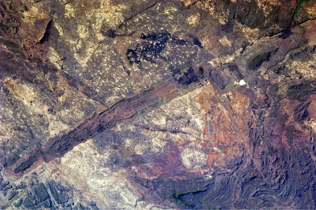
From the Air
The Great Dyke runs approximately 550 kilometers nearly north-south through central Zimbabwe, from around 17°S at its northern end down toward 20°S at the southern end. The reference point at 16.46°S, 31.14°E is near the northern section. Nearest major airport is Harare (HRE / Robert Gabriel Mugabe International), just east of the Dyke near its midpoint. The feature is visible from cruise altitude as a lineated band of hills and ridges running nearly north-south across the highveld - especially distinctive where it interrupts the otherwise gentle topography of the Zimbabwe Craton. Elevations along the Dyke range up to 1,700 meters; the surrounding plateau sits around 1,200-1,400 meters. Chrome and platinum mines cluster along its length as visible industrial features from the air. Best VFR conditions in the dry season (May-October).
Nearby Stories
- Centenary, Zimbabwe 12 km away
- Cahora Bassa 60 km away
- Luangwa River 70 km away
- Karoi 95 km away
- Tete Province 139 km away
- Lower Zambezi National Park 154 km away
- Luangwa Bridge 164 km away
- Dona Ana Bridge 372 km away