Tukuyu
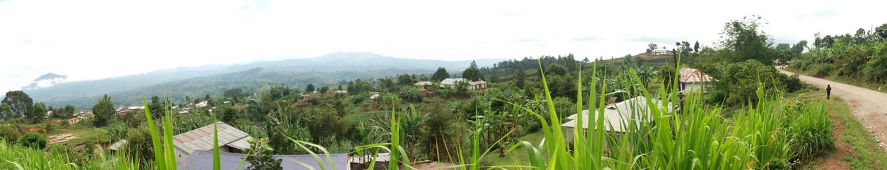
Tukuyu is not a place people travel to - it is a place people travel through. Buses marked for Mbeya or for Kyela stop here briefly, drop a few passengers, pick up a few more, and grind on. If you stay - and some travelers do - you discover something the buses never pause long enough to show: that Tukuyu sits in one of the most dramatic landscapes in Tanzania. The Southern Highlands rise around it in waves of green. Tea plantations carpet the hills in rows so straight they look drawn with a ruler. Mount Rungwe — the third-highest peak in Tanzania after Kilimanjaro and Meru — fills the horizon to the northeast. And a few kilometers off the main road, Ngozi crater lake lies in a perfect bowl, described as the second largest crater lake in Africa.
A Stop Between Two Places
Geographically, Tukuyu makes sense as a way station. It lies on the main road between Mbeya to the north and the Malawi border at Songwe to the south - an hour's ride to the border, two hours to Mbeya, by Coaster bus. Drivers mark their destinations on windshield cards; you flag the one heading your direction and climb aboard. The town itself is small enough to walk across in a quarter hour. No one bothers with taxis inside Tukuyu. For the surrounding area - where most of the worthwhile sights are - share taxis and bicycle taxis wait at the bus station, and organized tour operators lend mountain bikes to visitors who want to reach the ends of dirt tracks that cars cannot handle.
Mount Rungwe and the Crater Lakes
Mount Rungwe rises 2,981 meters, the first peak of the Southern Highlands and the third-highest peak in Tanzania. It is a dormant stratovolcano, and the land around it carries the marks of its volcanic past - craters, lakes filling craters, hot springs, and soil so rich that tea and coffee grow here with enthusiasm. Ngozi crater lake, the most famous of the craters, lies in a bowl whose walls rise several hundred meters from the water's edge; hikers reach it by a path that climbs through forest cool enough to feel alpine. Kaporogwe and Masusa waterfalls tumble through smaller valleys. God's Bridge - a natural stone arch carved by a river through solid rock - is another short hike from town. And Kitulo National Park, a high-altitude plateau sometimes called 'the Serengeti of Flowers' for the wildflower displays it produces in the rainy season, is close enough to visit as a day trip.
Tea and the People Who Grow It
The tea plantations that define the Tukuyu landscape are both a commercial crop and a way of life. Most of the tea grown here goes into Tanzanian black tea production, processed at factories scattered across the Southern Highlands and exported largely to Europe and the Middle East. Smallholder farmers grow tea on plots of a few hectares each, selling green leaf to larger processors on a regular pickup schedule. Plantation tours show how the leaves are plucked (still mostly by hand, from predawn to midmorning while the leaf is at its best), withered, rolled, oxidized, and dried. The tour is educational and gentle; the real work behind it is hard. A skilled plucker can handle 30 to 50 kilos a day, moving through the bushes with a rhythmic, two-handed technique that takes years to learn.
Staying and Leaving
Accommodations in Tukuyu are modest but adequate. The Langiboss Hotel, centrally located, is among the more popular places to sleep. An adult collective school in town sometimes welcomes travelers - they can arrange tents, food, and tours, and occasionally ask guests to teach a class in return for a Kiswahili lesson. Erick Village offers a homestay option for travelers interested in staying with a local family. For meals, Riverbanks Fishfarm Restaurant and Campsite draws visitors with fresh tilapia raised on site. When it is time to leave, the buses go both ways: two hours north to Mbeya for connections deeper into Tanzania, or an hour south toward Kyela and the Malawi border, where a bicycle taxi completes the final short leg across the frontier. Most travelers come to Tukuyu for a night. Those who stay longer usually wish they had planned for more.
From the Air
Located at 9.26 degrees south, 33.64 degrees east in Tanzania's Mbeya Region, 1,550 meters elevation. Served by small airstrips; nearest major airport is Mbeya's Songwe International Airport (HTGW) about 70 km north. From altitude, the dominant landmark is the massif of Mount Rungwe rising to 2,960 meters just northeast, with the Usangu plain to the north and Lake Nyasa (Malawi) visible to the south.
Nearby Stories
- Mbeya 15 km away
- Songwe Region 22 km away
- Chitipa District 40 km away
- Mbeya Region 52 km away
- Muchinga Province 128 km away
- Ruaha National Park 170 km away
- Udzungwa Mountains National Park 325 km away
- Cape Maclear 510 km away