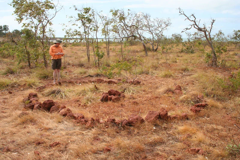

Wurrwurrwuy stone arrangements
Someone who had sailed on the ships came home and drew them in stone. On an open rocky shelf near Yirrkala, in eastern Arnhem Land, lie arrangements of stones that map the sailing vessels of the Makassan trepang fleets - laid out with such precision that you can trace a ship's crew quarters, its galley, its dining space, its store, even its water tank. These are not pictures of the sacred or the Dreaming. They are a Yolngu record of real events, real ships, and real people, made by men who had stood on those decks themselves. Wurrwurrwuy is history written in stone by the people who lived it.
Visitors on the Monsoon
For generations, perhaps from around 1750, seafarers from Makassar in present-day Indonesia sailed each year on the north-west monsoon to the coast of Arnhem Land. They came for trepang - the sea cucumber, bêche-de-mer, prized in Chinese kitchens - which they gathered, boiled, and dried on these shores before carrying it home to trade. When the explorer Matthew Flinders met a Makassan fleet off the English Company Islands in 1803, their captain Pobassoo explained the whole seasonal trade to him. Unlike encounters elsewhere on the continent, the relationship between Yolngu and Makassan was largely one of exchange rather than conflict. Goods, words, and customs passed between them, and some Yolngu sailed away on the praus to Makassar and beyond, returning with knowledge of a wider world.
Knowledge Set in Stone
The trade ended in 1906, when the government restricted the licences that allowed the Makassan fleets to come. But the memory did not fade, because Yolngu had fixed it in the ground. Oral history records that a man named Yumbul made the first stone pictures, and that his second son, Dhatalamirri, was entrusted with the site and added more. The arrangements spread across roughly 80 by 70 metres in three groups, depicting Makassan praus and houses, the stone hearths where trepang was boiled, and Yolngu camps, canoes, and fish traps. Some images are simple outlines; others use stones of different sizes to give weight and detail. The makers knew these ships intimately - their knowledge could only have come from sailing aboard them.
The Custodians Explain
In 1967 the researcher Campbell Macknight and Bill Gray of the Northern Territory Administration came to record the site, and two senior Yolngu men walked them through its meaning. Mungurrawuy Yunupingu, a Gumatj custodian - and a celebrated bark painter and father of future Yolngu leaders - and Mawalan Marika explained how the divisions within each stone vessel marked off its parts, and gave the Makassan names for the rudder, the bowsprit, the tripod mast and its rigging. Their account, published in 1969, showed that Yolngu had spent enough time aboard the praus to learn every working part. The custodians were clear about something else, too: Wurrwurrwuy held no sacred associations. It was, they said, a record of the past, kept so that younger men would understand the Makassan world their ancestors had known.
A Rare Kind of Record
That ordinariness is exactly what makes Wurrwurrwuy extraordinary. Across Aboriginal Australia, arranged stones are almost always tied to ceremony and the sacred; here, uniquely, they document the everyday and the historical. The detailed cutaway views of the praus - showing how a ship was laid out inside - are rare in Aboriginal depictions of vessels in any form at all. Australia recognised the significance: the site was added to the Northern Territory Heritage Register in 2007 and the Australian National Heritage List in 2013, listed in part for its sheer rarity. Today it is fenced, signposted, and cared for by Dhimurru's Aboriginal rangers - a Yolngu archive of cross-cultural history, still tended by Yolngu hands.
From the Air
Wurrwurrwuy lies at approximately 12.33 degrees south, 136.93 degrees east, on a coastal rocky shelf about 10 kilometres south-east of Yirrkala in eastern Arnhem Land, on the Gove Peninsula. From the air, look for the indented coastline south-east of Yirrkala where the land meets the Gulf of Carpentaria; the site itself is small (about 1.4 hectares) and best appreciated on the ground. The nearest airport is Gove Airport / Nhulunbuy (ICAO YPGV), roughly 20 km to the north. Dry-season skies (May to October) give the clearest coastal flying; the wet season brings monsoon cloud. Note this is Aboriginal land within the Dhimurru Indigenous Protected Area - visiting requires a permit, and the heritage-listed stones must not be disturbed.
Nearby Stories
- Laynhapuy Indigenous Protected Area 11 km away
- Bremer Island 14 km away
- Bäniyala 64 km away
- Gawa, Elcho Island 68 km away
- Chasm Island 118 km away
- Gulf of Carpentaria 206 km away
- Australia–Indonesia Border 238 km away
- Indonesia–Papua New Guinea Border 257 km away