Australia–Indonesia Border
You cannot see it, and no fence marks it, yet the maritime boundary between Australia and Indonesia stretches more than two thousand kilometers across three seas. What makes this border truly unusual is not its length but its layering: in some places, Australia owns the seabed while Indonesia owns the water column above it. The fish belong to Jakarta; the oil beneath them belongs to Canberra. This peculiar arrangement, born of decades of treaty-making and geopolitical compromise, runs from the Torres Strait in the east through the Arafura Sea and Timor Sea, finally terminating in the Indian Ocean south of Java.
The Anatomy of a Split Border
Most international boundaries separate territory cleanly. This one does not. Beginning with the 1971 and 1972 treaties, Australia argued that its continental shelf extended naturally northward along the seabed to the deep Timor Trough, a submarine trench lying just 40 nautical miles off the coast of Timor but more than 250 nautical miles from Australia. The resulting seabed boundary ran significantly closer to Indonesia than the geographic midpoint between the two countries. Indonesia's former Foreign Minister Mochtar Kusumaatmadja described the outcome bluntly: his country had been "taken to the cleaners." The 1997 treaty attempted a compromise, granting Australia its seabed claim while accepting Indonesia's argument for a median-line boundary governing the water column and exclusive economic zone. The result is a border that exists in two different places depending on whether you are looking down or looking up.
Three Seas, Three Segments
The boundary breaks into three distinct segments, each with its own character. The eastern segment begins at the tripoint where Australian, Indonesian, and Papua New Guinean waters converge in the Torres Strait, then runs westward through the shallow Arafura Sea. The western segment continues from the edges of East Timor's territorial waters across the deeper Timor Sea into the Indian Ocean. A third, separate segment lies far to the west, where Australia's Christmas Island territory sits 186 nautical miles south of Java in the Indian Ocean. Because Christmas Island is a small, isolated territory facing a large Indonesian coastline, the maritime boundary between them runs closer to the island than to Java — a modified median line that reflects the imbalance in coastal length.
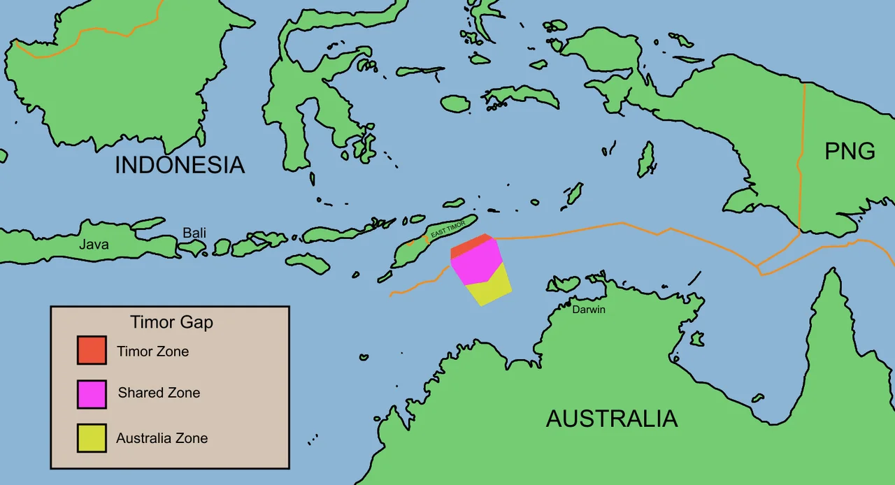
The Timor Gap
Between the eastern and western segments lies a gap — literally. The Timor Gap is the stretch of seabed where Australia and Indonesia could never agree on a permanent boundary, and where petroleum resources made the stakes too high for either side to concede. When East Timor was annexed by Indonesia in 1975, the two countries tried to negotiate. Talks began in 1979, stalled, and eventually produced a "sovereignty neutral" agreement in 1989 that allowed joint exploitation of oil and gas resources in a shared "zone of cooperation." That arrangement collapsed when East Timor declared independence in 1999. Indonesia notified Australia it was no longer bound by the Timor Gap Treaty. The dispute over the gap shifted from Canberra-Jakarta to Canberra-Dili, leaving the Indonesia border with a hole that remains unresolved.
Where Law Meets the Ocean Floor
The philosophical disagreement at the heart of this border shaped international maritime law. Australia championed "natural prolongation" — the idea that a country's continental shelf extends as far as the geology supports, regardless of distance. Indonesia favored the median-line principle enshrined in the 1982 United Nations Convention on the Law of the Sea, which draws the boundary equidistant from each country's coastline. The 1997 treaty split the difference in a way that satisfied neither side completely but acknowledged both principles. Flying over these waters, there is nothing to see but ocean. No buoys mark the boundary. No patrol boats hover at the transition point. The border exists entirely in treaty texts, on nautical charts, and in the legal frameworks that determine who may drill, who may fish, and who may claim the resources of the deep.
From the Air
Coordinates: 10.83°S, 139.20°E, in the western Torres Strait. Best viewed from 30,000–35,000 ft where the Arafura Sea stretches flat and featureless between Australia and New Guinea. Nearest airports: YBCS (Cairns), WAJJ (Sentani/Jayapura). The border region is open ocean with no visual markers; the Torres Strait islands are visible to the east.
Nearby Stories
- Marchinbar Island 206 km away
- Bremer Island 235 km away
- Booby Island (Queensland) 257 km away
- Wasur National Park 257 km away
- Janszoon Voyage of 1605–1606 268 km away
- Yirrkala 268 km away
- Badu Island 343 km away
- New Guinea Mangroves 394 km away