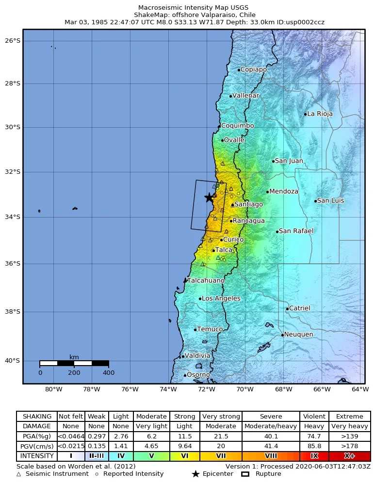

1985 Algarrobo Earthquake
It began offshore, in the dark water between Algarrobo and the open Pacific, where one slab of the Earth had been grinding beneath another for longer than anyone had been counting. At 7:47 on the evening of 3 March 1985 - a warm Sunday at the end of the southern summer - that locked seam finally let go. The shaking lasted the better part of a minute and reached magnitude 8.0, strong enough to throw furniture across rooms in Santiago and Valparaíso, sixty miles inland. By the time the dust settled, at least 177 people were dead, around 2,575 were injured, and close to a million Chileans had no safe home to return to.
Eleven Days of Warning
The ground had been muttering for almost two weeks. Starting on 21 February, a swarm of small tremors rolled through the coast near Valparaíso - more than 360 of them, day after day, none large enough to cause real harm but frequent enough to fray nerves across the region. Scientists noticed. Chilean and Mexican seismologists scrambled for funds to ship in portable instruments and set up temporary stations, sensing that something larger might be building under the seabed. They were right, though no one could say when. Foreshocks are honest about danger and silent about timing. When the mainshock arrived on that Sunday evening, it confirmed every quiet fear the swarm had raised, and then far exceeded them.
A Country Built on a Fault
Chile lives on one of the most active subduction zones on the planet, where the Nazca Plate slides beneath South America at roughly the speed your fingernails grow. That slow collision raises the Andes and, every few decades, snaps loose in a great earthquake. The 1985 event tore a stretch of that boundary near the coast and sent a destructive local tsunami sweeping in behind it. The damage was staggering in its arithmetic: more than 85,000 homes destroyed, twelve hospitals so badly broken they had to be replaced, and Rengo Hospital collapsed entirely. Remarkably, not one patient died inside those failed buildings - a small mercy threaded through an enormous loss.
Counting the Hurt
Disaster resists tidy numbers. A study by Chile's Ministry of Health later admitted how hard it was simply to know how many people had been hurt, and how badly. Records were lost when clinics fell. Files were misplaced in the chaos; beds vanished as buildings were condemned. From the wreckage of paperwork the authors assembled what they could - a detailed look at 1,623 of the injured, 811 women and 784 men - and acknowledged a fuller toll of around 2,575. Behind each entry was a person: someone caught under a wall, someone who carried a neighbor to safety, someone whose heart gave out in the terror of the aftershocks. The figures matter precisely because they stand in for lives.
The World Comes to Listen
Out of catastrophe came one of the most thoroughly studied earthquakes in Chilean history. Aftershocks kept the region on edge for weeks, including a magnitude 7.4 the next day and a 7.2 event near Rapel Lake on 9 April that killed two more people. As the earth kept moving, scientists arrived to learn from it. United States Geological Survey seismologists Mehmet Celebi and George Plafker landed on 21 March carrying extra seismometers, which Chilean and Mexican universities deployed to better trace the aftershocks. Teams from New Zealand, Britain, and several American universities joined the surveys. What they recorded reshaped earthquake engineering, and the lessons - written in the rubble of 1985 - still stiffen the buildings that keep Chileans alive today.
From the Air
The rupture zone lies offshore near 33.24 degrees south, 72.04 degrees west, in the Pacific just west of Algarrobo and the Greater Valparaíso coast. From cruising altitude on clear days you can trace the whole stage of the disaster at once: the long beach line of the central Chilean coast, the port of Valparaíso to the north, and the Maipo valley reaching inland toward Santiago. The nearest major field is Santiago's Comodoro Arturo Merino Benítez International (SCEL), about 110 km east; Viña del Mar's Rodelillo aerodrome (SCRD) sits closer to the coast. Coastal marine layer often blankets the shoreline in the morning, so late-day light gives the cleanest view of the bays where the tsunami came ashore.
Nearby Stories
- Iglesia de la Matriz 25 km away
- La Campana National Park 25 km away
- Huaca de Chena 58 km away
- Battle of Maipú 59 km away
- Pichilemu 91 km away
- Chanco, Chile 240 km away
- Cobquecura 316 km away
- 1687 Peru Earthquake 2014 km away