2023 Guayas earthquake
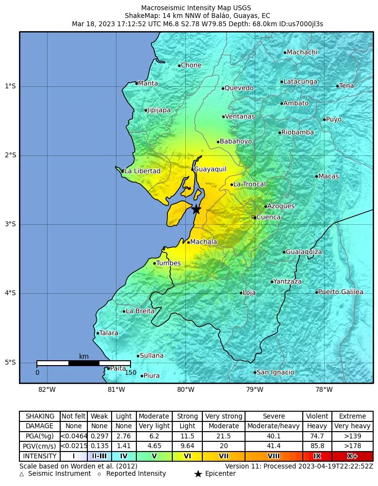
On the afternoon of March 18, 2023, a Saturday, the ground beneath southern Ecuador lurched. The Nazca plate, sliding eastward beneath the South American plate at roughly seven centimeters a year, released accumulated strain at intermediate depth - deep enough that the rupture radiated outward through hundreds of kilometers of rock. Within seconds, shaking reached Guayaquil, then Cuenca, then Machala. By the time the tremor faded, 8.41 million Ecuadorians - nearly half the country - had felt the ground move. Sixteen would not live to see Sunday.
A Country Built on a Fault
Ecuador sits in a geological pressure cooker. The Nazca plate, born at Pacific spreading ridges, dives beneath South America at the continent's western edge, and that collision built the Andes. It also built Ecuador's population centers, its highland cities, its farmland terraces. Everything above ground stands on something that refuses to stay still. The Geophysical Institute of the National Polytechnic School, Ecuador's seismic watchdogs, has logged 32 earthquakes of magnitude 6.0 or greater within 250 kilometers of this particular event over the past century. The country has learned to count the interval between shakings rather than assume there won't be one. The 2023 event struck about 14 kilometers NNW of Baláo at magnitude 6.8 - a number that reads small on the page but that the physics makes brutal in practice. Oblique-slip faulting within the subducted Nazca slab sent seismic waves racing upward and outward.
Guayaquil at 12:12 in the Afternoon
In Ecuador's largest city, glass rained. Six buildings collapsed outright. Seventy-three more took damage that would render them uninhabitable. Store shutters rattled down mid-transaction. Three vehicle tunnels sealed shut. Power failed across the northern and southern sectors of Guayaquil, and in some neighborhoods, it would be seven hours before the lights came back on. Out on Puná Island, closest inhabited land to the epicenter, ten houses simply came apart. In Naranjal, a smaller town south of the city, one person died. The USGS recorded shaking intensity VI - strong - in Guayaquil itself, with zones of V-VII stretching across the provinces of El Oro, Azuay, and Guayas. For a city of three million people, an earthquake this size is not a disaster movie. It is a Saturday afternoon that never quite ends.
The Sea Took the Museum
In Puerto Bolívar, a coastal district of Machala in El Oro province, a building housing both a museum and a restaurant collapsed into the sea. The image - a structure that had stood above the water for years now sunk beneath it - became one of the most widely shared of the disaster. Elsewhere in El Oro, forty houses collapsed. Three people died when a tower came down on top of them. Further inland, in Cuenca - the colonial jewel of the Andes, the provincial capital of Azuay - two more people died. One was killed when a house façade sheared off and fell onto a parked car. A teenager was buried when another house collapsed. Landslides took others. These are the numbers the headlines carry, but they hide a different truth: 96 houses gone completely, 318 damaged beyond easy repair, 148 schools cracked open, 55 health facilities compromised at precisely the moment they were needed most.
What Came After
President Guillermo Lasso visited the affected provinces the next day. He declared a 60-day state of emergency covering 14 provinces, opened emergency funds for health and housing, and warned that the casualty count would climb in the coming hours. It did. The Confederation of Indigenous Nationalities of Ecuador - CONAIE, the country's most important Indigenous political organization - launched its own aid campaign, reaching communities that government response sometimes overlooked. In the National Assembly, lawmaker Blanca Sacancela proposed that assembly members donate half their salaries to earthquake victims. The proposal did not even reach debate. Something smaller but stranger also happened: 39 people were left homeless, 101 more displaced in lesser ways, and the bureaucratic work of rebuilding began - a process that in earthquake-prone countries is never really finished, only paused between tremors.
Living on the Carnegie Ridge
Part of what makes Ecuador's seismic landscape so complicated is that the Nazca plate carries with it the subducted remnants of the Carnegie Ridge - an oceanic plateau formed long ago as the plate slid over the Galápagos hotspot. Where the ridge slides under Ecuador, the plates lock tighter than elsewhere. Strain accumulates differently. Faults behave differently. The country's main active fault zones - Pallatanga, Chingual, Quito - run in patterns that would take geologists decades to map. From the air, none of this is visible. What you see is the spine of the Andes, the Gulf of Guayaquil opening west, and a country that has learned, generation by generation, to build lower and reinforce more than might seem necessary on a quiet day.
From the Air
Coordinates: 2.85°S, 79.80°W. Epicenter 10 km NNW of Baláo, Ecuador. Recommended viewing altitude: FL240-FL300. Nearby airports: SEGU (Guayaquil - José Joaquín de Olmedo), SESM (Machala - Santa Rosa), SELT (Cuenca - Mariscal Lamar). The Gulf of Guayaquil is the most visible landmark, with the city of Guayaquil on its northeast shore. Puná Island sits in the gulf near the epicenter. Typically humid coastal weather with afternoon convective buildups; early-morning visibility is best.
Nearby Stories
- Cuenca (Ecuador) 9.6 km away
- El Guabo Canton 24 km away
- Ingapirca 27 km away
- Battle of Yaguachi 52 km away
- Battle of Punta Malpelo 53 km away
- Tumbes 81 km away
- Pedro Carbo Canton 90 km away
- Zamora 102 km away