Cuenca (Ecuador)
The water from the tap in Cuenca is safe to drink. This sounds like nothing until you realize what it means. Across Ecuador, across most of Latin America, travelers and locals alike filter, boil, or buy bottled water. In Cuenca, you fill a glass at the sink. The city's utility built new mains between 2010 and 2013 covering 8,000 hectares, and the water arrives from the paramo wetlands of Cajas National Park thirty kilometers west, cold and clean. Some locals claim it is purer than what comes out of European taps. Whether the boast holds up to laboratory testing or not, it captures something about how Cuenca thinks of itself: a city that has gotten a few things right where its peers have not.
Four Rivers and a Valley
Cuenca's full name is a geography lesson in miniature: Santa Ana de los cuatro rios de Cuenca. Cuatro rios means four rivers, cuenca means basin, and the city sits exactly where those rivers converge in a highland bowl at 2,500 meters. The Tomebamba, Yanuncay, Tarqui, and Machangara all meet here, having flowed down from the paramo wetlands of Cajas National Park to the west. Walking Cuenca, you cross these rivers constantly. Riverside paths run through the center. Cottonwood and paper-bark trees line the banks. The Tomebamba river, which takes its name from the Canari culture that lived here before the Inca, forms the southern edge of the historic district and the logical boundary between colonial old town and the newer neighborhoods climbing the hills beyond.
The Domes on the Plaza
Three large sky-blue domes rise over Parque Calderon, the central square. The New Cathedral, begun in the 1880s and completed mid-twentieth century, is Cuenca's unavoidable landmark. Look carefully at the facade between the central statue and the rose window and you can spot the vertical crack that gives the building character. For three dollars, visitors can climb to the rooftop terrace for a view across the terra-cotta tiles of the historic center. Across the plaza stands El Sagrario, the old cathedral, where construction began in 1557 in the first months of Spanish settlement. El Sagrario is no longer a working church - it has become a museum, its original paintings and murals carefully restored. Between the two cathedrals, on the benches of Parque Calderon, Cuencanos sit and watch the day pass.
Cajas in the Morning
An hour west of the city, 270 alpine lakes sit scattered across a paramo landscape that looks genuinely Scottish until you notice the llamas. El Cajas National Park covers 28,500 hectares and the fastest way to reach it from Cuenca is the local bus from Terminal Terrestre for about a dollar. Route One, the shortest popular hiking loop, runs three miles and winds through a forest of queñua trees - the paper-bark high-altitude trees whose shredding red bark gives them their common name. The altitude changes everything. At 3,500 to 4,400 meters, even a gentle climb takes the breath, and the weather turns from sunny to hammering hail in minutes. Rangers at the entrance check passports and recommend, firmly, that inexperienced hikers take a guide.
Pase del Nino
On December 24, Cuenca stages the largest Christmas parade in South America. The Pase del Nino Viajero - the Passage of the Travelling Child - begins at San Sebastian at ten in the morning and moves along Simon Bolivar, through Parque Calderon, and ends in San Blas. It runs for at least seven hours. Thousands of children dress as Joseph, Mary, the Three Kings, angels, and assorted biblical figures; neighborhoods decorate trucks, horses, and donkeys with symbols of the nativity; musicians accompany each contingent. The procession honors a statue of the infant Jesus that was taken on pilgrimage to the Holy Land in 1961 and returned to the city, and it has grown into an event that draws people from across Ecuador. November's Festival de Independencia is the other great calendar fixture: four days of art, crafts, street food, and music celebrating the city's independence from Spain on November 3, 1820.
Panama Hats from the Market
The hat called Panama is not from Panama. It is from Ecuador, and many of the finest examples are woven in and around Cuenca from the fibers of the toquilla palm. The name stuck because workers building the Panama Canal wore them and photographs of Theodore Roosevelt in one made the style famous in the United States. In Sigsig, an hour east of Cuenca, a cooperative of women weaves the hats to a density that earns the top designation of superfino - tight enough that the hat can be rolled and passed through a wedding ring. Cuenca's markets stock hats at every grade and price point. Flower vendors fill the Plaza de las Flores across from the new cathedral, selling tight-packed bunches in a riot of color. Just down the street, the artisan market sells handwoven ruanas, knitted alpaca sweaters, embroidered textiles from Otavalo, and Chordeleg silver.
Onward
Cuenca is many travelers' last stop in Ecuador before crossing into Peru. The border at Huaquillas-Tumbes is the standard route, reached by Pullman Sucre buses from Terminal Terrestre - a roughly five-hour ride south before immigration, then a transfer to a CIFA bus that continues through Aguas Verdes and into Tumbes. The mechanical details of the journey have shifted over the years, but the basic geography has not: leaving Cuenca means descending from the Andean highlands into the hot coastal plain, watching the cool dry air give way to humid tropics somewhere in the pass. For those going the other direction, toward Quito, the Panamericana climbs north for ten hours. The tram across Cuenca itself, operational since 2020, covers 10.7 kilometers and 20 stops.
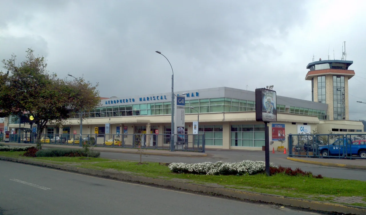
From the Air
Cuenca lies at 2.90 S, 79.02 W at 2,500 meters elevation in a highland basin. Mariscal Lamar International Airport (SECU) sits on the northeast edge of the city at 2,530 meters - Ecuador's third-busiest. Recommended approach from Guayaquil crosses El Cajas paramo at 10,000-12,000 feet. Afternoon weather over the Andes unpredictable; morning departures preferred. Four rivers visible as light threads through the historic center; three sky-blue cathedral domes the unmistakable landmark from the air.
Nearby Stories
- Ingapirca 12 km away
- Cueva de los Tayos 27 km away
- 2023 Guayas earthquake 39 km away
- El Guabo Canton 43 km away
- Battle of Yaguachi 56 km away
- Saraguro People 62 km away
- Eastern Cordillera Real Montane Forests 85 km away
- Borja, Peru 173 km away