The Night the Mosques Fell
The worshippers inside Jabal Nur Mosque in Lading-Lading village had just begun their isha prayer when the ceiling came down. More than 50 people were buried in the rubble of their own place of worship. Across North Lombok, the same scene repeated itself -- mosque after mosque crumbling during the evening's final prayer, trapping congregations beneath concrete and tile. The magnitude 6.9 earthquake that struck at 7:46 p.m. on August 5, 2018, killed 563 people, injured over a thousand, and displaced more than 400,000 from an island of three million. It was the deadliest event in a seismic sequence that had been punishing Lombok for a week, and it would not be the last.
Where Tectonic Plates Collide
Lombok occupies one of the most seismically volatile positions on the planet. The island sits on the Pacific Ring of Fire, where the Australian plate dives beneath the Sunda plate at roughly 50 millimeters per year, forming the Sunda Trench to the south. To the north, the collision has pushed the volcanic arc over the back-arc basin along the Flores Thrust, a 500-kilometer zone of fracture that has produced powerful earthquakes for centuries. The Sunda Arc has generated catastrophic events before -- the 1977 Sumba earthquake, the 1994 Java earthquake, the 2006 Pangandaran earthquake and tsunami. But the 2018 Lombok sequence, with three major quakes in 22 days, was something different. The Flores Thrust was rupturing along multiple segments in rapid succession, and the soft volcanic and sedimentary rocks near the epicenter amplified the shaking far beyond what the raw magnitude might suggest.
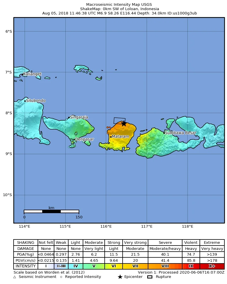
The Ground Rises, the Buildings Fall
The earthquake's epicenter was inland, near Loloan village on the northeastern slopes of Mount Rinjani, at a depth the USGS measured at 34 kilometers. The fault rupture spread northward until it reached the sea, generating a tsunami that BMKG initially predicted would be just 50 centimeters. At Kayangan, the wave came in at two meters. On Gili Trawangan, tourists and residents scrambled for the hills. On Gili Air and Gili Meno, there are no hills -- people waited in open fields. Days later, NASA and Caltech published satellite imagery showing the earthquake had lifted parts of northern Lombok by 25 centimeters and dropped Mount Rinjani's summit by 15 centimeters. The provincial capital Mataram recorded shaking intensity of VIII on the Modified Mercalli scale -- Severe. More than 80 percent of structures in North Lombok were either damaged or destroyed. The total damage would eventually be estimated at 8.8 trillion rupiah, roughly $607 million.
Trapped on the Gili Islands
When the earthquake cut power to most of Lombok, the Gili Islands went dark. More than 1,700 people -- 700 residents and 1,000 tourists -- were stranded on the three small islands northwest of Lombok's coast, surrounded by debris and the threat of tsunami. Cafes and resorts on Gili Trawangan had been severely damaged. Convenience stores stood abandoned by their owners, and looting was reported. Tourists described chaos during the evacuation: no coordination among authorities, no information in English. BNPB officials confirmed that some boat operators demanded two million rupiah -- about $140 -- to transport stranded visitors to the airport, and that evacuees who could pay the most were taken first. By the afternoon of August 7, 4,636 people had been evacuated to the ports of Bangsal, Lembar, and Benoa. The experience exposed how quickly the infrastructure of a tourist economy can collapse when the ground moves beneath it.
A Nation Responds
Indonesia mobilized on a scale that matched the disaster. President Joko Widodo ordered Lombok International Airport to operate around the clock. The military deployed KRI Dr. Soeharso, a hospital ship, alongside aircraft carrying troops and medical supplies. The Indonesian Red Cross sent 26 tonnes of aid. Regional governments contributed what they could: West Sumatra shipped a ton of rendang to feed displaced families; West Java sent 3.5 billion rupiah. In Jakarta, a band of cabinet ministers -- the Finance Minister, the Foreign Minister, the Transportation Minister -- performed a benefit concert that raised 2.2 billion rupiah. The Transportation Minister then sold his guitar for another 200 million. During the opening ceremony of the 2018 Asian Games, held in Jakarta and Palembang just weeks later, the stadium fell silent for the victims of Lombok. In North Lombok, where 198,846 people -- out of a population of roughly 215,000 -- were living in refugee camps, the solidarity was welcome. But the needs were staggering: 42,239 houses damaged, 458 schools destroyed, and an earthquake sequence that still had one more major event to deliver.
Why the Damage Was So Devastating
The death toll -- 563 from the August 5 quake and its aftershocks, 565 across all August tremors -- reflected more than seismic force. Indonesia's disaster management agency cited a lack of construction regulations, insufficient technical knowledge among builders regarding earthquake resistance, and the economic inability of many residents to build stronger homes. The foreshock of July 29 had already weakened thousands of structures. When the mainshock arrived a week later, buildings that had survived the first event failed under the second. Aftershocks continued the destruction: a magnitude 5.9 on August 9 killed six more, including two Indonesian Red Cross volunteers, and a magnitude 6.3 on August 18 killed two. By the time the sequence finally ebbed, the island's infrastructure had been systematically dismantled by a fault system that seemed to target the same communities over and over again.
From the Air
The epicenter of the August 5, 2018 earthquake lies at approximately 8.29S, 116.45E, on the northeastern slopes of Mount Rinjani in North Lombok. From altitude, the 3,726-meter volcano dominates the island, with landslide scars visible on its northern flanks. The Gili Islands -- Trawangan, Meno, and Air -- are visible just northwest of the Lombok coast, small and flat against the Lombok Strait. Lombok International Airport (WADL/LOP) is located in the island's south. Across the strait to the west, Bali's Ngurah Rai International Airport (WADD/DPS) sustained ceiling damage but remained operational. The Flores Thrust runs through the seafloor north of the island, invisible from the air but responsible for everything below.
Nearby Stories
- Lombok 25 km away
- The Invisible Frontier: Where Asia Ends and Australia Begins 26 km away
- Nusa Penida: Bandit Island Turned Bali's Last Refuge 55 km away
- The Island Diana Chose 56 km away
- Eight Patrols and a Midnight Torpedo 66 km away
- Forty-Five Men and Thirty-Six Depth Charges 73 km away
- The Island That Shook the World 100 km away
- Isuzu: The Cruiser That Refused to Sink 129 km away