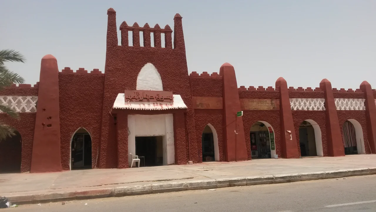

Adrar, Algeria
Everything here is the color of the ground. The walls, the gateways, the saw-toothed parapets that catch the low sun - all washed in the same red-ochre clay that the wind carries off the surrounding desert. Adrar does not contrast with the Sahara so much as rise out of it, a city the exact shade of the land it sits on. This is the administrative seat of Algeria's second-largest province, a place of roughly 65,000 people at the time of the 2008 census, growing fast. But its real story is older than any census, and it runs underground.
The Color of the Land
Adrar belongs to a category of place that barely exists anymore: a working desert town that still looks the part. The traditional architecture is built for survival in extreme heat - thick earthen walls, few windows on the outside, narrow lanes engineered to hold shade through the worst of the afternoon. Across the older districts and the newer ones alike, the buildings keep to a single palette of red and ochre, finished with the geometric ornament of Saharan tradition. The crenellated rooflines give the skyline a serrated edge, as if the whole city had been cut from the same block of clay. At 258 meters above sea level, ringed by oasis on its southwest side, Adrar is the largest settlement of the Touat oasis group - and the most striking expression of how people learned to live in one of the hottest inhabited places on Earth.
Water From Below
Nothing about Adrar makes sense without the foggaras. These are gently sloping underground channels - hand-dug galleries that tap groundwater far out under the desert and carry it, by gravity alone, into the oasis to water the palm groves. The incline is almost nothing, sometimes a millimeter or two per meter, so that water moves without ever being pumped. The Touat, Gourara, and Tidikelt oasis groups together hold the densest concentration of these channels anywhere, with more than 2,000 kilometers of underground galleries threaded beneath the sand. For centuries the management of a foggara's flow defined everything above ground - who farmed, who governed, who held standing in the community. Without this buried engineering, the date palms die and the town with them. It is one of the great quiet feats of Saharan civilization, invisible from the air and essential to everything you can see.
Crossroads of the Sands
Long before it was a provincial capital, Adrar was a stop. The Touat sat astride the caravan routes that linked the Mediterranean world to Sub-Saharan Africa, and the trade that crossed here was the trade that mattered: salt heading south, gold heading north, alongside grain, cloth, and dates. The oases produced the food that let caravans rest and resupply before the next brutal leg, and the dates - the region's old currency of wealth - were valuable enough to carry as cargo in their own right. That history of intermingling left a cultural inheritance you can still feel: a folklore, a body of craft traditions, and historic monuments scattered through a region settled since deep antiquity. Adrar was a hinge between two worlds, and the worlds rubbed off on it.
Heat and Wind
The climate here is uncompromising. Adrar averages around 15 millimeters of rain in an entire year. Summer afternoons routinely push toward 46 degrees Celsius, and even in early May or late August the thermometer can climb to 48 - that is 118 degrees Fahrenheit. The nights barely cool, often holding near 27 degrees. Then there is the Sirocco, the scorching southerly wind that lifts off the Sahara and dries everything in its path, sometimes blowing for weeks at a stretch and reaching all the way to Algeria's northern coast. Winter offers a reprieve - warm, dry, sunlit days, though the nights can turn surprisingly cold, and frost is not unheard of. To build a thriving town in this furnace, and to keep it green, required exactly the underground water and thick-walled architecture that define the place.
The Modern Desert City
Adrar today is a fully functioning hub. Its airport, named for Cheikh Sidi Mohamed Belkebir, sits about ten kilometers from the center and connects the oasis to Algiers, Oran, Ouargla, and the remote far south at Bordj Badji Mokhtar. The N6 national highway runs north toward Bechar and south toward Reggane, the old caravan path now paved. The town has grown quickly since Algerian independence, on the back of housing and infrastructure projects, and it carries a strong record of education - among the highest literacy rates in the province. But the desert around it also holds a harder chapter: nearby Reggane, a town in the same province, was the site of the Reggane series of French nuclear tests conducted between 1960 and 1961, a reminder that this remote stretch of Sahara was once treated as a place far enough from everywhere to matter to no one. The people of the Touat would disagree. They have been making this ground livable for a very long time.
From the Air
Adrar sits at 27.87°N, 0.29°W, at roughly 258 m (846 ft) elevation in the Touat oasis belt of the Algerian Sahara. The local airport is Touat Cheikh Sidi Mohamed Belkebir Airport (ICAO: DAUA), about 10 km from the center. From the air, look for the distinctive red-ochre town set against the green of the oasis to its southwest, with the vast Erg Chech sand sea to the west and the rocky Tademaït plateau to the east. Best viewing in winter, when skies are clear and the heat haze of summer is absent; expect blowing dust and reduced visibility during Sirocco conditions. Recommended viewing altitude 3,000-6,000 ft AGL to take in the oasis, the foggara-fed palm groves, and the abrupt edge where cultivation meets open desert.
Nearby Stories
- Touat 30 km away
- Erg Chech 384 km away
- Erg Iguidi 582 km away
- Béryl Incident 612 km away
- Siege of Laghouat 676 km away
- Ait Benhaddou 702 km away
- Tin Hinan Tomb 716 km away
- Fes 801 km away