Águas Claras, Federal District
Thirty-three years ago, this was empty cerrado. Now it is high-rises - forty-story towers clustered around an elevated metro line, dense in a way almost nothing else in the Federal District is dense. Brasília, Brazil's capital, was famously built by Lúcio Costa in the 1950s as a low-rise, airy modernist experiment with generous green space and clean axial geometry. Águas Claras is its opposite - a vertical city planned in 1992 under the direction of architect and urbanist Paulo Zimbres, intended to compress residential density into a compact footprint at the western edge of the capital. The result has been rapid, sometimes chaotic, and often criticized. It has also been successful, by the measure that matters most to its 135,000 residents: it exists.
The City That Came After the Capital
When Brasília was planned and inaugurated between 1956 and 1960, Lúcio Costa and Oscar Niemeyer designed it as a Modernist ideal - a city of 500,000 spread across superblocks of six-story apartment buildings, separated by parks and wide avenues. But the workers who built Brasília needed somewhere to live, and the satellite cities that emerged to house them - Taguatinga, Ceilândia, Samambaia, and others - grew far beyond any original plan. By the early 1990s, the Federal District faced a housing pressure the Costa plan had never anticipated. On December 16, 1992, District Law 385 authorized a new administrative region to be carved from the existing Taguatinga: Águas Claras. The land was raw cerrado, chosen for its position along a planned extension of the Federal District Metro line. Paulo Zimbres, a Brazilian architect associated with dense urban solutions rather than Niemeyer-style openness, designed the occupation plan. The plan allowed towers. It allowed vertical growth at a scale Brasília itself had refused.
Vertical Brasília
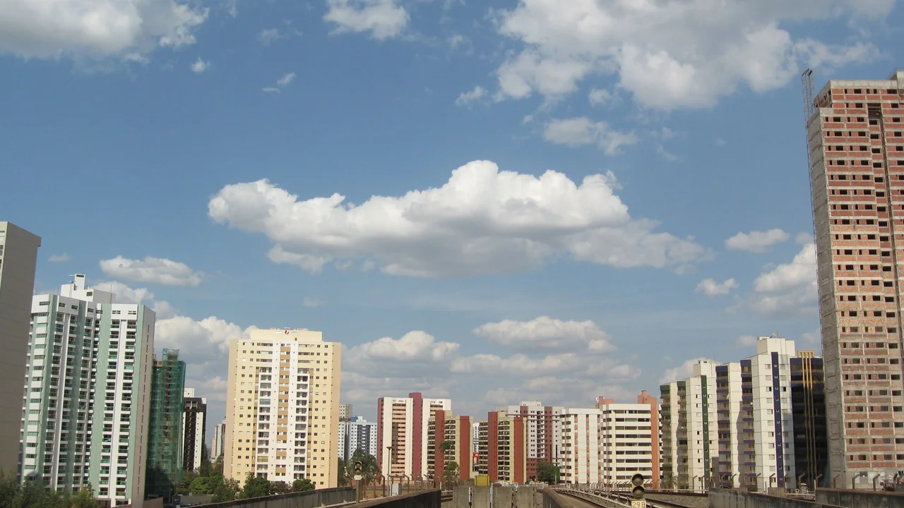
What followed was a real estate boom. Developers moved quickly into Águas Claras once the plan was approved, raising residential towers along Avenidas Araucárias and Castanheiras, the arterial streets that parallel the Metro line. The buildings rose faster than the public infrastructure that was supposed to support them. Hospitals, public schools, parks - the civic amenities that ideally accompany residential density - lagged behind. The population tripled between 2005 and 2011. By 2023, Águas Claras counted more than 135,000 residents within its 31.5 square kilometers. The density reverses everything about Brasília: instead of six-story superblocks with sky visible overhead, Águas Claras offers 25 and 30-story towers packed shoulder to shoulder along narrow streets, with wind tunnels between buildings and afternoon shadows that fall early. The architectural effect is jarring to visitors who expect more Niemeyer. To residents who needed apartments, it worked.
Four Stations on the Line
The Federal District Metro splits Águas Claras in two, running on an elevated viaduct along the long axis of the city. Four stations serve the district: Arniqueiras, Águas Claras, Concessionárias, and Estrada Parque. This is the spine that makes everything else function - a 20-minute train ride to the central Plano Piloto of Brasília, connections to Taguatinga and Ceilândia, a rapid-transit link that millions of people depend on. In January 2009, a set of four viaducts opened to ease street traffic, making Araucárias and Castanheiras one-way with the avenues flanking the metro bearing the reverse direction. In 2010, the renovated EPTG highway - Taguatinga Park Road - cut travel times to central Brasília. Bike lanes followed in 2019, though incompletely. A bus rapid transit system, BRT-Oeste, has been planned for years. Public transportation remains, in the words of local residents and planners, insufficient. The metro trains run crowded. Bus stops often lack shelters. The chronic problems of the wider Federal District play out here at particularly high volume.
Clear Waters, Still Flowing
The city's name means 'clear waters' - a reference to the stream that still flows through the district and drains into Paranoá Lake, the artificial reservoir Brasília's planners created in the 1960s as the capital's recreational heart. The stream survives. So, here and there among the towers, do patches of original cerrado - scraps of vegetation that developers did not clear, now protected as small urban parks where children play football and older residents walk dogs in the late afternoon. The 21st Police Station in the neighboring district of Areal handles law enforcement for Águas Claras. The 135,000 residents commute to Brasília for specialized medical care, for most public schooling, and for the federal jobs that dominate the capital's economy. What they return home to is a vertical Brazilian city that did not exist thirty-three years ago - an accidental experiment in how Brazil might house its urban populations when the Modernist dream proved insufficient. The verdict is still arriving.
From the Air
Located at 15.84°S, 48.03°W in the Federal District of Brazil. Águas Claras occupies 31.5 km² in the western portion of the Federal District, bordered by Vicente Pires, Guará, Park Way, Arniqueira, and Taguatinga. The city's distinctive vertical skyline is visible from altitude - a dense cluster of high-rises at the edge of the lower-density sprawl surrounding Brasília. Brasília International Airport (SBBR) lies approximately 15 km east. The Federal District Metro line, running on elevated viaduct through the district, appears as a distinctive linear feature from above.
Nearby Stories
- Luziânia 9.9 km away
- Contagem Biological Reserve 13 km away
- Formosa, Goias 18 km away
- Corumbá de Goiás 31 km away
- Formosa 44 km away
- Anápolis 50 km away
- Unaí 64 km away
- Ceres, Goiás 122 km away