.jpg)
Formosa
The rock art in the hills around Formosa is 4,500 years old. Paleo-Indians left cave paintings and rock engravings at the Stone Lapa and the Archaeological Site of Bisnau, in the district between Bezerra and JK, and anyone who hikes there can still see the figures, some so faint they appear only under raking light at certain angles. The Formosa you visit today was founded much later. In the eighteenth century, settlers of the Arraial of Saint Anthony fled a malaria outbreak in the Parana valley and regrouped on higher ground with the drovers and traders who had come down from Bahia and Minas Gerais, camping in tents made of leather hides they carried for trade. The town's first name was Arraial dos Couros, the Leather Tents Camp.
Named for Beauty
The municipality of Formosa was officially created on August 1, 1843, and the name means simply beautiful, chosen for the character of the surrounding highland landscape. The town sits at about 1,000 meters elevation on the central Brazilian plateau, about 100 kilometers northeast of Brasilia along BR-020. The drive from the federal capital takes the direction of Sobradinho through cerrado and agricultural country, and the route was historically the path by which travelers and official commissions first explored this region. Formosa retains a frontier quality that the Federal District has long since traded for modernist planning, and the town still feels like what it is: a small city in the middle of a huge agricultural landscape, anchor for ranches and a launch point for waterfalls.
The Cruls Commission
In 1892, the Cruls Commission came through Formosa on its way to mapping out the future capital. Led by astronomer Luiz Cruls, the commission was tasked with surveying the Central Plateau and demarcating the quadrilateral within which Brazil's new capital would eventually be built. The main team toured Corumba, Santa Luzia (which became Luziania), and Mestre d'Armas (which became Planaltina), arriving in Formosa on September 14. A smaller advance party led by Cruls himself reached Formosa on August 23 via a different route. On September 15 the combined expedition left Formosa heading toward Mestre d'Armas, following the path of the Viscount of Porto Seguro. The result of this survey was the Cruls Quad, the demarcated area inside which Brasilia was ultimately built and inaugurated on April 21, 1960. Formosa sits just outside that quad, in Goias rather than in the Federal District, but the city was part of the story of how the capital got located.
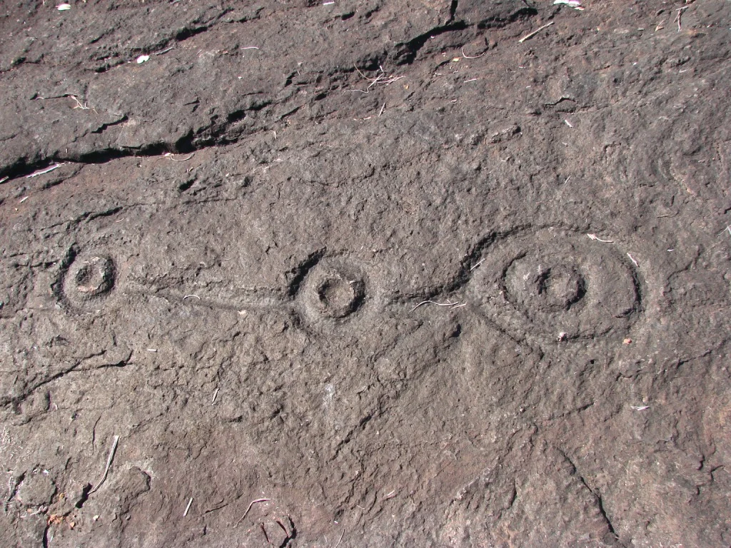
Bisnau and the Rock Paintings
The Bisnau Waterfall drops 130 meters over the rock face about 20 kilometers from the District of Bezerra, with six smaller falls arranged along the descent and bathing pools at the top and bottom. You can walk the edge, rappel the wall, or take the steep trail through primary rainforest. Near the waterfall lies the archaeological site of the same name, one of 29 archaeological sites clustered in the area, featuring rock engravings and bas-relief paintings in monochrome. Local guides say the figures include symbols no one has been able to read, and the oldest art here predates the Egyptian pyramids. The Lajedo, about 19 kilometers from Bezerra, is a stretch of riverbed worn so smooth it looks machined, falls dropping into a pool of crystal-clear water three meters deep. The Poco Azul is a translucent spring in virgin forest, nine meters deep. Santana Falls drops in two stages, the second about 80 meters high, hard to access but the kind of place where you do not encounter other visitors.
Macaws' Hole
Buraco das Araras, the Macaws' Hole, is one of the largest quartzite sinkholes in Brazil. It is 105 meters deep and 295 meters wide. Rainforest grows at the bottom, and a cave at one edge holds an underground river where you can snorkel with the right flashlight. Rappelling into the crater is the standard approach, though a difficult foot trail exists for the determined. The macaws that gave the sinkhole its name no longer live here, reduced by illegal pet-trade poaching, but the site remains one of the most dramatic geological formations in the region. Gruta das Andorinhas, the Cave of the Swallows, lies 21 kilometers from Bezerra and reaches 250 meters underground. The Jabuticabeira Cave runs two kilometers through cold clear water, with stalactites and stalagmites lit by flashlight and an eight-meter waterfall at the end. Toca da Onca, the Jaguar's Nest, tunnels 200 meters under a massive limestone boulder on the Capetinga farm. The jaguars that gave it its name once raided cattle ranches in the area, though that was long ago.
Getting Around
Formosa does not have its own airport. Flights land at Brasilia and the drive from there is about 100 kilometers. A rental car is essentially required to see the waterfalls, caves, and archaeological sites, since many of them are 20 to 40 kilometers from town on roads that can become problematic during the rainy season from October to April. Bring flashlights for the caves. Bring swim gear for the pools. Go with a local guide for the sites where the trail conditions or crime concerns warrant it. Formosa pairs well with a few days in Brasilia, giving travelers a chance to see the modernist capital and the ancient cerrado landscape around it in the same trip, two layers of human presence separated by thousands of years but only a couple hours' drive.
From the Air
Formosa sits at 15.54 S, 47.33 W, about 100 km northeast of Brasilia in Goias. Cruise at 4,500 to 6,500 feet to view the surrounding cerrado plateau dotted with the archaeological sites and waterfalls. Brasilia International Airport (SBBR) is the nearest major airport. The elevation around 1,000 meters keeps temperatures moderate (average 25C) year-round.
Nearby Stories
- Brasília 3.6 km away
- Contagem Biological Reserve 11 km away
- IBGE Ecological Reserve 65 km away
- Mambaí 113 km away
- Niquelândia 115 km away
- Alto Paraíso de Goiás 131 km away
- Posse, Goiás 168 km away
- Das Velhas River 257 km away