Alto Paraíso de Goiás
The 14th parallel runs straight through Machu Picchu in Peru and then, six thousand kilometers east, cuts across a small concrete monument on the GO-118 highway in central Goiás. This spot, the Jardim Zen, is nothing special to look at - a few stones, some flowers, a weathered marker - but it tells you most of what you need to know about Alto Paraíso. The town grew into the main gateway for Chapada dos Veadeiros, one of Brazil's most spectacular national parks, and somewhere along the way it also became a magnet for Daimists, Kardecists, Hare Krishnas, Buddhists, and several dozen other spiritual communities convinced that the massive quartz crystal layer underfoot does something to the local frequencies.
The Gateway on the Highway
Alto Paraíso sits 230 kilometers from Brasília along the BR-010/GO-118, close enough to be reachable in a long morning's drive but far enough to feel like you have entered different country. The transition is visual. Red earth, twisted cerrado trees, stone arches marking the city portal, an outdoor sculpture called Little Stonehenge sitting parallel to the road. The elevation climbs steadily - the Mirante do Pouso Alto, the highest point in Goiás state, rises to 1,676 meters - and the air thins enough that first-time visitors from the coast notice their breath. The main drag, Avenida Ary Valadão Filho, cuts straight through town. Two blocks to either side, and you have seen essentially all of downtown.
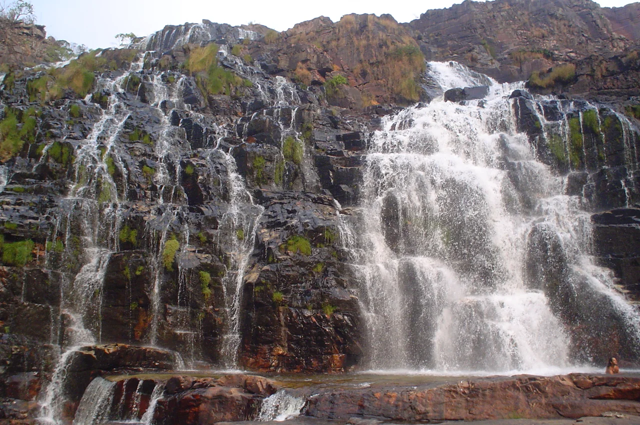
The Hundred Waterfalls
What Alto Paraíso really offers is its geography. The Tocantins headwaters gather here in the Rio Preto, the São Miguel, and the Couros, three rivers whose names anyone serious about Brazilian waterfalls eventually memorizes. Cataratas dos Couros, 28 kilometers out on rough dirt road, drops through four linked falls. Almécegas I plunges off a cliff edge in a single sheet; Almécegas II is its wider sibling pool below. Vale da Lua, on the Rio São Miguel, carved the rock into such smooth lunar hollows that the name wrote itself. Not for swimming - the current has killed careless visitors - but for looking at, and there are few landscapes in Brazil quite like it. Sertão Zen requires eight kilometers of hard hiking. Anjos e Arcanjos rewards a medium trek with falls where locals jump the 35-meter drop between them.
São Jorge, the Other Town
Thirty-six kilometers west of Alto Paraíso sits São Jorge, a village at the actual entrance to Chapada dos Veadeiros National Park. Alto Paraíso locals summarize the relationship with one blunt rule: quiet people stay here, party people stay in São Jorge. The road between the two towns, now mostly paved with a parallel bike lane, runs through scenery that justifies the whole trip. Half is still dirt. In the rainy season, October through April, the dirt part tests your patience and your rental car's suspension. But this is the cerrado at its most photogenic - red cliff escarpments, gallery forests, the kind of sky that demands attention after dusk. The park itself has trails ranging from easy strolls to full-day hauls over irregular rock.
Crystals and Communities
Alto Paraíso is home to something like 40 spiritual communities, a density unusual even by New Age standards. Daimists brew ayahuasca under Brazilian legal protections. Kardecists run spiritist centers. Buddhists maintain small monasteries. Hare Krishnas chant on Main Avenue. The theory the residents offer involves that quartz crystal layer underground and the Age of Aquarius and the parallel that links them to Machu Picchu. Whether any of it is true is less interesting than what it produces on the ground: a town full of crystal shops, vegetarian restaurants, retreat centers, and therapeutic services, where hippie clothing and pinga de arnica (cachaça infused with spicy arnica) share counter space. UFO sightings are casually reported. Morro da Baleia - Whale Hill, named for its shape - comes with its own catalog of mystical stories.
When to Come
The cerrado dry season runs May through September, which is also when the waterfalls are safest and the trails firmest. October through March brings the rains, and with them warnings about flash floods on rivers like the São Miguel that feeds Vale da Lua. Many waterfalls require a 4WD vehicle - Vale do Rio Macaco and Cataratas dos Couros in particular - and local guides are often required for the more remote canyons. Budget travelers work with hostels like Reges on the main avenue. The small airport handles private aircraft only; commercial travelers fly into Brasília and drive. Pack for significant temperature swings. This is high cerrado country, and the thin dry winter nights can drop to single digits Celsius while the afternoons push into the 30s.
From the Air
Coordinates 14.13°S, 47.51°W, elevation approximately 1,200 m with nearby peaks rising to 1,676 m at Mirante do Pouso Alto. Recommended viewing altitude 6,000-9,000 ft AGL to appreciate the Chapada dos Veadeiros escarpment country and the surrounding Pouso Alto environmental protection area. Small local airport serves private aircraft only; nearest major airport is Brasília International (SBBR) 230 km southwest. The terrain is mountainous cerrado with deep canyons and waterfall systems - avoid low-level flying without local knowledge. Best visibility May through September during the dry season.
Nearby Stories
- Cavalcante 22 km away
- Niquelândia 33 km away
- Minaçu 40 km away
- Monte Alegre de Goiás 74 km away
- Posse, Goiás 80 km away
- Mambaí 108 km away
- Mara Rosa 110 km away
- Planaltina, Goiás 116 km away