Das Velhas River
The Rio das Velhas means, translated literally, the River of the Old Women. The name is strange enough that people ask. The Tupi-speaking peoples who lived along it called it Uaimii, in which gwaimi means old and the final i means river. The bandeirantes - the Portuguese slaving and prospecting expeditions that pushed into the interior in the 1600s - wrote it down as Guaicui and translated the meaning roughly into Portuguese. The river keeps the awkward 17th-century translation. It also keeps, embedded in its water, an entire history of Brazilian gold, Brazilian colonial violence, and Brazilian environmental reckoning.
The Road to the Gold
Recent academic research argues that the das Velhas may have been the original path by which Brazilian gold was found. The conventional story has bandeirantes from Sao Paulo pushing north over the Serra da Mantiqueira. The revisionist version has prospectors from Brazil's northeast walking the banks of the Sao Francisco River and turning up the Das Velhas - a longer but more natural passage that carried them directly into the heart of what would become Minas Gerais, the General Mines. What both versions agree on is that somewhere in the late 17th century, probably in the 1690s, the gold was found. Boomtowns rose along the das Velhas and its tributaries: Sabara, Santa Luzia, eventually Belo Horizonte. The river was both road and reward.
War of the Emboabas
The gold was too much to share. The original Paulista discoverers - the bandeirantes - considered the mines theirs by right of discovery. The newcomers from Portugal and the northeast, whom the Paulistas called emboabas (a Tupi word for outsiders, often translated as feather-footed chickens referring to Portuguese trousers that covered the calves), arrived in growing numbers and claimed their own shares. Open conflict broke out between 1707 and 1709 - the War of the Emboabas, a brutal series of raids and skirmishes culminating in a massacre at Capao da Traicao. The Paulistas lost. The Portuguese crown intervened, and in 1720 Minas Gerais became a captaincy directly under royal administration. The das Velhas remained the transit spine of the gold economy. Mule trains carried the wealth north along its valleys and eventually out to the Atlantic.
Source at Ouro Preto, Mouth on the Sao Francisco
The river rises at the Andorinhas waterfall in the municipality of Ouro Preto - appropriately, in the town that became the most fabled of the gold-era boomtowns. From that headwater it runs northwest for roughly 800 kilometers, gathering tributaries from the iron-rich soils of central Minas Gerais, until it empties into the Sao Francisco River at a place called Barra do Guaicui, near the town of Varzea da Palma. It is the longest tributary of the Sao Francisco, Brazil's third-longest river system. Along the way it passes Sabara, where colonial gold merchants once weighed dust, and threads through the modern edge of Belo Horizonte, a city of six million that did not exist when the river was named.
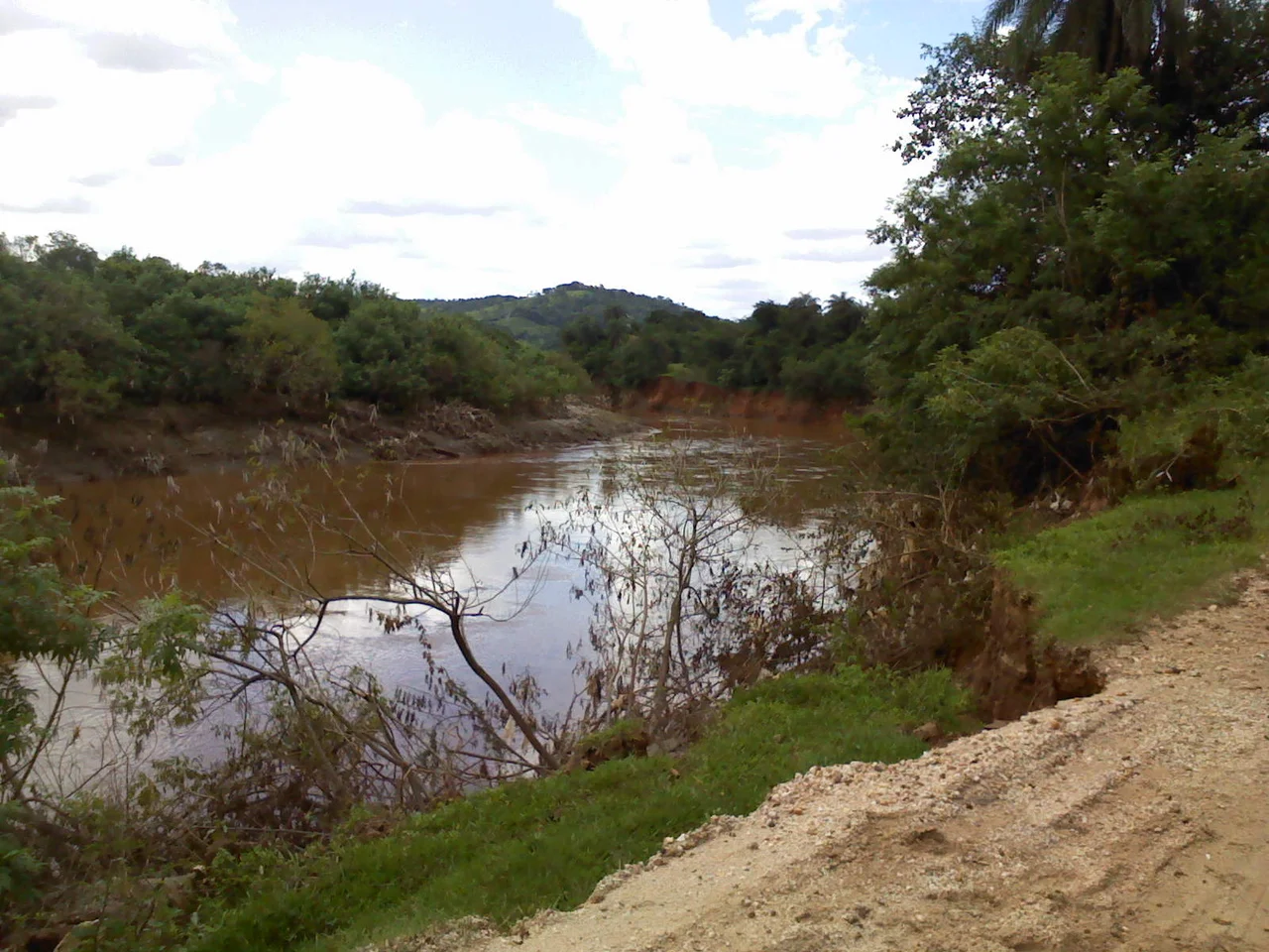
The Yellow Stretch
In Greater Belo Horizonte the river is not what it was. A significant part of its water volume is diverted at the Agua de Bela Fama Water Treatment Station. Downstream of that, the Ribeirao Arrudas and the Onca streams - both of which drain directly through the city of Belo Horizonte - deliver heavy loads of domestic and industrial sewage. The iron-rich geology adds dissolved iron oxides, tinting the water yellow. The result, in the river's best-known urban stretch, is water that is polluted, acidic, and largely lifeless. Fishermen who worked the river within living memory moved elsewhere. What remained was the stain.
The Manuelzao Project
In 1997 the Medical Faculty of the Federal University of Minas Gerais did something unusual for a medical school - it launched a river restoration project. The Manuelzao Project, named for a traditional herdsman celebrated in Brazilian literature, set out to revitalize the entire das Velhas basin. The project mobilized public opinion, pushed for stricter pollution controls, and set a goal of restoring the river to fishable condition by 2010. That deadline came and went. Progress was real but partial. Fish have returned to some stretches where they had been absent for decades. In 2014 the federal government created the 31,270-hectare Serra do Gandarela National Park, partly to protect the springs and watersheds that feed the Das Velhas. A river that was once the road to Brazil's first great wealth is slowly being treated as its own kind of treasure. The gold went to Lisbon three centuries ago. The river is what stayed behind.
From the Air
The Das Velhas runs roughly northwest across central Minas Gerais, rising at 20.38 degrees S, 43.50 degrees W near Ouro Preto and reaching the Sao Francisco at about 17.20 degrees S, 44.83 degrees W near Varzea da Palma - a stretch of roughly 800 kilometers. The plotted coordinate here is at the Sao Francisco confluence. Best viewed from 4,000 to 8,000 feet AGL along any stretch - the river meanders through agricultural valleys between the Espinhaco and Serra da Canastra ridges. Nearest airports are Belo Horizonte/Confins (SBCF) at the midpoint and Pirapora (SNPX) near the mouth. Look for the yellow-to-brown tint of the water as it passes through the Belo Horizonte urban zone.
Nearby Stories
- Três Marias 100 km away
- Rio Preto State Park 133 km away
- Grão Mogol 154 km away
- Januária 162 km away
- Pico do Itambé State Park 172 km away
- Unaí 174 km away
- Vazante 177 km away
- Cristalina 244 km away