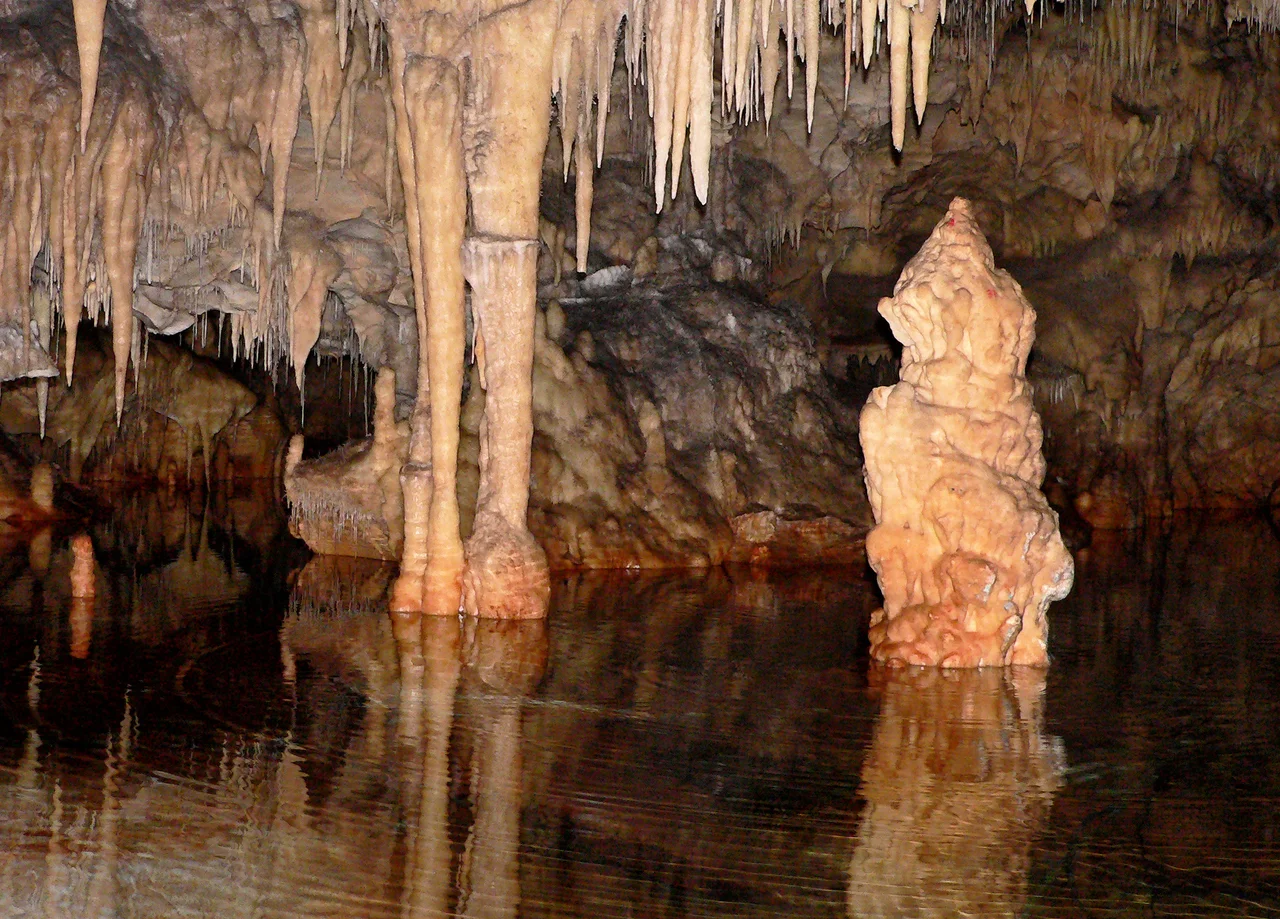

Alepotrypa Cave
The Greeks call it Alepotrypa — the Fox's Hole. But what early farmers found here, tucked into the limestone cliffs of the Mani Peninsula about 50 meters from the sea, was far grander than the name suggests: a cave system 300 meters long, with six large chambers, multiple corridors, and a deep lake at its far end whose water is slightly brackish but drinkable. For thousands of years during the Neolithic period, a community made this place the center of their world. They lived near the entrance, buried their dead within, and conducted ceremonies in the deepest chambers. Then an earthquake sealed the opening, preserving everything inside — and leaving a community's entire accumulated life, from their worn pottery to their most sacred rituals, waiting for archaeologists to find it more than five millennia later.
A Community's Layered World
One of the most striking things about Alepotrypa is how deliberately its inhabitants organized the space. Near the entrance, where light reached and daily life happened, excavators found the traces of ordinary existence: the debris of worn tools, heavily used pottery, evidence of structures. These were people who farmed barley and wheat, who made and repaired things, who moved in and out of the cave as part of their daily round.
Deeper in, the atmosphere changed. The innermost chambers held the evidence of ceremony: decorated vessels that had been deliberately broken, jewelry and tools placed with apparent intent rather than discarded. In the deepest reaches, at the Chamber of the Lakes, that brackish underground lake reflected the torchlight of people gathering for purposes that went beyond the practical. Archaeologists read this spatial organization as evidence of a sophisticated religious and social life — a community that understood its cave as having different zones of meaning, and maintained those distinctions across generations.
The Dead, and What They Left Behind
Remains from at least 170 individuals have been recovered from Alepotrypa, making it one of the largest known Neolithic burial sites in Europe. These were people who chose — or were chosen — to rest here, in the same chambers where the living conducted their ceremonies. Archaeologists have found evidence of non-lethal head injuries on some skulls, suggesting that violence was part of life in this Neolithic community, as it was in most human communities across time.
The most evocative find came from a burial dating to the 4th millennium BC: two adults, their skeletons positioned as if in an embrace. They are now known as the Embracing Skeletons of Alepotrypa. We cannot know whether they died together, were buried together deliberately, or what relationship they had. But their arrangement — preserved in stone for six thousand years — carries an undeniable human weight. Whatever ceremony accompanied their interment, someone cared enough to place them this way.
The community that buried its dead here was also wealthy by Neolithic standards. Silver jewelry — extraordinarily rare in prehistoric Europe — was found at the site. Obsidian blades from the island of Melos, approximately 200 kilometers away, indicate long-distance trade connections. A copper axe from the Final Neolithic period bridges the transition to the Early Helladic era. These were not isolated people; they were embedded in networks that reached across the Aegean.
Stone, Water, and the Memory of a Gate to the Underworld
The cave itself is a karst formation — limestone dissolved over millions of years by slightly acidic water, producing chambers, corridors, and eventually an underground lake. The Mani Peninsula's Mesozoic limestone is particularly suited to this process, and the Pyrgos Dirou complex, of which Alepotrypa is part, contains some of the most dramatic cave systems in Greece.
The cave sits about 20 meters above sea level and 50 meters from the present Mediterranean shoreline. During the Neolithic, when sea levels were lower, the relationship between cave and coast was different — the landscape has continued to change since the people who lived here walked these chambers.
Some archaeologists, including lead excavator Giorgos Papathanassopoulos, have hypothesized that the cultural memory of Alepotrypa persisted into classical antiquity — that later Greeks associated it with Tainaron, the mythological entrance to the underworld. Cape Tainaron (now Cape Matapan) lies at the southernmost point of the Mani, not far to the south. Whether the myth grew from memory of this cave, we cannot say. But the idea that a place where so many had been buried, sealed by earthquake and lost to living knowledge, could become a story about a door to the land of the dead — that connection feels like something more than coincidence.
Excavation and the Long Work of Understanding
The cave's modern history began close to destruction. Between 1958 and 1970, private construction threatened the site. The Greek Ministry of Culture intervened, cancelling what was euphemistically called the 'touristic exploitation' of the cave. Systematic archaeological excavation began in 1970 but was delayed until 1978 by the political turmoil of the period. The main excavation ran from 1978 to 2005, led by Papathanassopoulos, and since then the project has been largely paused for lack of funding.
What has been recovered is remarkable. Beyond the human remains and the silver and obsidian, trace element analysis of the cave's stalagmites has provided evidence of the burning of dung fuel by the Neolithic inhabitants — and also of climate variation, including periods of drought, that affected the community's life. The cave is, in a sense, still being read. Its stalagmites record the climate of the Neolithic the way tree rings record climate in forests: layer by layer, year by year, a slow archive of a world that no longer exists.
From the Air
Alepotrypa Cave is located at 36.639°N, 22.382°E on the western coast of the Mani Peninsula, near the village of Pyrgos Dirou, approximately 9 km south of Areopoli. From the air at 2,000 to 4,000 feet, the Mani Peninsula appears as a rugged limestone ridge running south toward Cape Matapan (Cape Tainaron), Europe's southernmost mainland point. The coast here is dramatic — steep cliffs dropping to a blue sea. The cave entrance is not visible from altitude, but the general area around Pyrgos Dirou is identifiable by the small harbor. Nearest airport: LGKL (Kalamata International), approximately 65 km to the north. The surrounding landscape is bare and rocky, with the characteristic gray-white limestone of the Mani giving way to deep blue water to the west.
Nearby Stories
- Battle of Pylos 8.6 km away
- Battle of Sapienza 14 km away
- Agios Vasileios — Mycenaean Palace of Laconia 16 km away
- Epidaurus Limera 18 km away
- Leonidio 28 km away
- Battle of Cape Spada 110 km away
- Siege of Chania (1645) 181 km away
- El-Kouf National Park 409 km away