
Angle, Pembrokeshire
On 15 February 1996, an oil tanker called the Sea Empress lost steering and ground onto the rocks just outside Milford Haven, less than two miles from the village of Angle. Seventy-two thousand tonnes of crude oil went into the sea over the following week. The black tide reached almost every beach on the Pembrokeshire south coast and the cleanup eventually cost about £60 million. Walk Angle Bay today and you would never know. The mudflats are clean. The dunlin and curlew probe the silt as if nothing happened. But almost nobody who lives in Angle is shy about telling you the story, because for a while in February 1996 they thought their stretch of coast was finished.
The Tip of the Peninsula
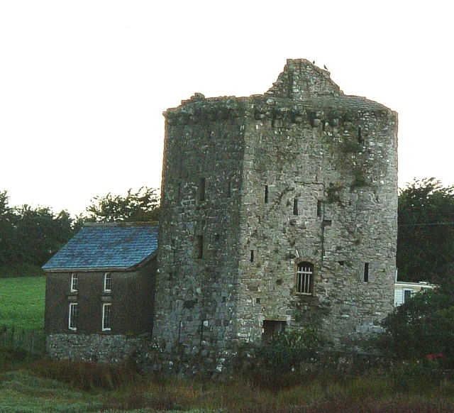
Angle sits at the western tip of the south Pembrokeshire peninsula, on the southern side of the Milford Haven Waterway's entrance. The community is small enough that the village school and the village shop have both closed, leaving the church, the Globe Hotel, and the lifeboat station as its functional anchors. Behind the houses, on Castle Farm, stands a Pele tower; above Castle Bay are the earthwork remains of an Iron Age fort; and on the headland the strip-farming pattern of medieval fields is still visible from the air as a fossil of medieval land use. A 19th-century report counted 388 people in the village. The women plaited straw for bonnets and matting. The men trawled for oysters when they were in season.
A French Landing in 1405
Angle is one of the few places in Britain that can claim a French invasion. In 1405, during the Welsh revolt led by Owain Glyndwr, a French army landed at Angle to support him. The chapel and small castle at Castle Farm may have been built by the Shirburn family around that time. Some sources read the surviving fragments as a simple defensive pele tower; others see traces of a moat and a second tower, the remains of a much larger Norman castle. The medieval chapel inside the farm has a Celtic cross finial and Victorian stained glass showing Christ walking on the sea, a fitting choice of subject for a village whose men still drown if the boats go wrong. Castle, chapel, tower, and farmyard all sit within fifty paces of each other, the layers compressed.
The Mirehouse Village
Shortly after 1800 the Angle estate was bought from the Kinner family by John Mirehouse of Brownslade for £29,000, and the Mirehouses became Angle's chief landowners for generations. They refurbished The Hall in the 1830s and made it their seat. The High Sheriff of Pembrokeshire was a Mirehouse in 1831 and again in 1886, by which time the family had taken back its original surname (a descendant had previously been a Levett of Staffordshire). Lt. Col. Richard Walter Byrd Mirehouse rebuilt large parts of the village in eclectic Victorian style, most visibly the castellated, almost colonial-looking Globe Hotel, which is still the dominant building on Angle's main street. The family still lives at The Hall today; a councillor John Allen-Mirehouse served as Deputy Leader of Pembrokeshire County Council in recent decades. The village reads as a Victorian estate village because it largely is one.
Forts, Bunkers, and a Rare Starfish
Milford Haven has been a strategic anchorage for centuries, and the cliffs around Angle prove it. In the 1860s, on the orders of Lord Palmerston, a series of forts went up to defend the haven against a French invasion that never came: Angle alone sat among four of them (Thorne Island, East Blockhouse Battery, Chapel Bay, and Stack Rock Fort). In the next century RAF Angle operated from the peninsula's interior from 1 December 1941 into the 1950s, jointly with the Royal Navy. The Site of Special Scientific Interest at West Angle Bay is more delicate. Its rock pools shelter Asterina phylactica, a tiny green cushion starfish formally identified as a species only in 1979. Geoffrey Wainwright, MBE (1937-2017), the British archaeologist who excavated Durrington Walls and re-investigated Stonehenge's bluestone sources in Pembrokeshire, was born in Angle. A small village. A very long memory.
From the Air
Angle sits at 51.68 N, 5.09 W on the south shore of the Milford Haven Waterway entrance, at the western tip of the south Pembrokeshire peninsula. From the air the village reads as a clutch of houses around a curving sandy bay, with the Pele tower at Castle Farm and the elongated outline of Thorn Island Fort just offshore to the west. The Iron Age fort on Castle Bay is visible from low altitude in oblique light. Recommended viewing altitude: 1,500-2,500 feet. Nearest airport is Haverfordwest (EGFE) about 8 nm to the north-northeast; the disused RAF Angle airfield occupies the higher ground on the peninsula's interior. Watch for LNG tanker traffic in the haven approach.
Nearby Stories
- Abercych 1.3 km away
- Pendine Sands 6.4 km away
- HMS H47 20 km away
- HMHS Glenart Castle 43 km away
- Ilfracombe Lifeboat Station 45 km away
- Johnstown Castle 67 km away
- Hook Lighthouse 98 km away
- 1979 Fastnet Race 142 km away