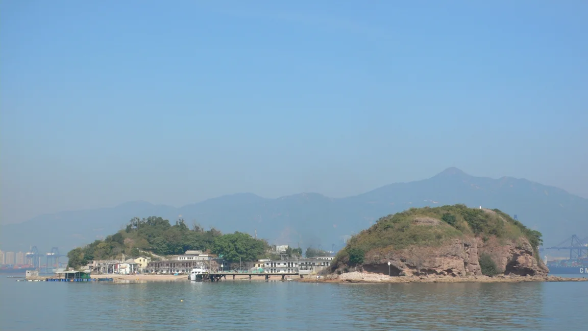

Ap Chau
The island looks, from above, exactly like its name says it should. Ap Chau means Duck Island in Cantonese, and seen from the air the shape is unmistakable: a duck's body resting on the water of Crooked Harbour, its distinctive head formed by the rocky northern promontory that juts into the sea. At just 0.04 square kilometres, it is the smallest inhabited island in Hong Kong — smaller than many a city car park — and as of 2017, three people call it home.
The Fishermen Who Came First
Ap Chau spent most of its history as an uninhabited rock. Until the early twentieth century, no one lived there permanently, though fishing boats occasionally sought shelter in the harbour. The change came in the 1920s, when Tanka fishermen — members of an ethnic minority with deep roots in the coastal waters of southern China — began anchoring their boats off the island and using its land for drying nets and making repairs. The Tanka people had long lived on the water itself rather than on shore, a way of life that set them apart from the surrounding Cantonese and Hakka communities. Ap Chau's sheltered position in Crooked Harbour made it a natural stopping point. By the 1940s, some of those fishermen had decided to stop moving. Informal settlements appeared on the island's small patch of level ground, and what had been a temporary anchorage became a permanent home.
The Village Built on Faith and Foreign Aid
The formal village of Ap Chau was established in 1961, constructed with financial support from the United States CARE programme and the British colonial government. The community that took shape there was devout: a church went up alongside the houses, and it is still active today. Through the island's connection to the True Jesus Church, a Christian denomination with deep roots in China, word of Ap Chau spread to overseas communities. Emigrants from the island settled in British cities including Newcastle upon Tyne, Leicester, Sunderland, and Elgin, establishing a diaspora that reached further than the island's size might suggest. It is a remarkable thread — from a three-person island in the South China Sea to Chinese communities scattered across northern England and Scotland.
The Duck's Eye
Nature shaped the island's most famous feature in the northern rocks. The Duck's Eye Sea Arch — also known as the Ap Chau Sea Arch — is a natural opening two metres tall and ten metres wide, carved by centuries of seawater erosion working steadily through the sedimentary rock. What makes it remarkable is not just its shape but its practicality: the arch stands above sea level, which means visitors can actually walk through it safely. It is the only sea arch in Hong Kong that offers this experience, and it draws considerable attention from hikers and photographers who make the journey out to Crooked Harbour. The surrounding geology, built from Jurassic and Cretaceous sedimentary rocks, earned the northern part of the island a place within the Double Haven Special Area, a conservation zone designated in 2011.
Getting There
Reaching Ap Chau is not straightforward, and that is rather the point. The island sits within a zone that requires a restricted area pass to access via the Sha Tau Kok Public Pier, a legacy of the border security arrangements that have governed this corner of Hong Kong since the Cold War. An alternative route runs from Ma Liu Shui pier, where kaito — the small ferries that serve Hong Kong's outlying islands — make weekend and public holiday trips to Ap Chau and the nearby island of Kat O. Since April 2018, the Ap Chau Story Room has been open on Sundays and public holidays, housed in the building that once served as the island's primary school. Fresh water still arrives from mainland China through an underground pipe — a quiet reminder that even the most remote corners of Hong Kong are connected to the continent just kilometres away.
From the Air
Ap Chau sits at approximately 22.55°N, 114.27°E in the Crooked Harbour area of northeastern Hong Kong's New Territories, close to the Shenzhen border. From the air, the island is recognizable by its duck-like silhouette in the sheltered waters between the mainland and Kat O. The Shenzhen skyline is clearly visible to the north. Nearest major airport is Hong Kong International (VHHH), approximately 45 kilometres to the southwest. On approach from the west, Mirs Bay and the scatter of islands in Crooked Harbour form a distinctive pattern in the blue-green water below.
Nearby Stories
- Basalt Island 7.1 km away
- Ngong Ping 360 7.5 km away
- China Southern Airlines Flight 3456 11 km away
- Huizhou (Guangdong) 27 km away
- Dongguan 27 km away
- Battle of Penghu 471 km away
- Penghu Air Raids 477 km away
- Checheng Fu'an Temple 593 km away