Bahir Dar
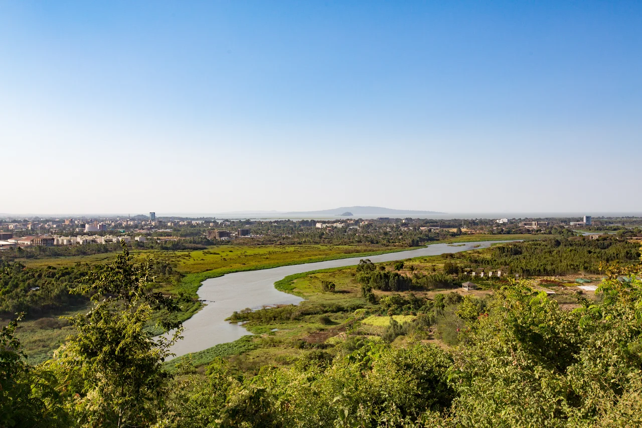
The Blue Nile leaves Lake Tana here. If you walk down to the waterfront in Bahir Dar, Ethiopia, and watch for a while, you can actually see the river emerging from the lake - a single broad stream beginning its 1,450-kilometer journey north through Sudan to meet the White Nile at Khartoum, eventually reaching the Mediterranean at Egypt. Bahir Dar is the capital of the Amhara Region, a city of roughly 400,000 people at 1,820 meters of elevation. The avenues are wide and palm-lined. In 2002, UNESCO awarded Bahir Dar its Cities for Peace Prize for handling rapid urbanization with unusual grace. The city started as a monastery - Bahir Giyorgis, George-by-the-Water - and for most of its history held between 1,200 and 2,000 people. Its transformation into a modern capital happened in a compressed few decades of the twentieth century, and it shows.
Where the Nile Begins
Bahir Dar sits at the exit of the Abay - the Ethiopian name for what Sudan and Egypt call the Blue Nile - from Lake Tana. Lake Tana itself is Ethiopia's largest inland body of water, designated a UNESCO Biosphere Reserve in 2015, and a destination for pilgrims who come to its island monasteries. The lake holds the tombs of emperors including Yekuno Amlak, Dawit I, Zara Yaqob, and Fasilides, interred in isolated monasteries where men pray the same liturgy that has been prayed here for seven centuries. Thirty kilometers downriver from town, the Blue Nile Falls - Tis Abay, Great Smoke - plunges 42 meters over a basalt cliff, though Ethiopian hydroelectric diversion has reduced its peak flow. Bahir Dar is the base camp from which visitors reach all of it.
A Town of Many Communities
When Ethiopian government surveyors reached Bahir Dar in 1930, they found a village with considerable trading activity and a highly stratified social structure. At the top stood the kahenat - the clergy - and the balabbat, landowners. Below them lived three tenant-craftsman communities: tanners, Muslim weavers, and the Weyto stone-mill grinders - the last an ethnic minority with their own language. These communities were economically interdependent but socially separate. None intermarried. The Italian occupation of 1936-1941 disrupted the old hierarchy and imposed new quarters: an Italian camp, a Muslim quarter, a Weyto settlement. Tea-rooms and bars run by foreigners appeared. Bahir Dar became, in one historian's phrase, a melting-pot of different people and cultures - though the melting was done without much Ethiopian consent.
A Capital Made Quickly
The Italians chose Bahir Dar as their administrative center for the southern Lake Tana territories partly because of its water power. Engineers had been studying Lake Tana's outflow for decades - British teams under Dupis, Grabham, Black, and Cheesman between 1902 and 1934, all wondering whether a barrage could regulate the Blue Nile's flow for agriculture downstream in Sudan and Egypt. Most of that work fed hydroelectric plans rather than dams. When the Ethiopian People's Revolutionary Democratic Front, the EPRDF, captured Bahir Dar at 18:10 on 23 February 1991 during Operation Tewodros, they inherited a town of modest size and big plans. In the 1990s, after the EPRDF made it the capital of the new Amhara National State, Bahir Dar grew at over five percent a year. From 2007 to 2023, the city's annual population growth averaged 5.31 percent - one of the fastest rates in Ethiopia.
June 2019
On the evening of 22 June 2019, gunmen loyal to the Amhara nationalist general Asaminew Tsige attacked government offices in Bahir Dar as part of a regional coup attempt. Ambachew Mekonnen, president of the Amhara Region, was assassinated in his office, along with his advisor Ezez Wassie and the regional attorney general Megbaru Kebede. Hours later, in Addis Ababa, a bodyguard with coup sympathies killed General Se'are Mekonnen, the chief of staff of the Ethiopian National Defense Force, and his aide Major General Gizae Aberra. Ethiopian police killed Asaminew Tsige near Bahir Dar on 24 June. The coup attempt failed. It also announced a political fracture within Ethiopia's ruling coalition that has since widened into the War in Amhara, a conflict that continues to affect the city and the farmers in its hinterland.
The Everyday City
On an ordinary afternoon, though, Bahir Dar looks like what UNESCO saw in 2002: a lakeside city of palm trees and colonial villas, the campus of Bahir Dar University stretching west from the market, tour boats running out to the Zege peninsula, students in uniform walking home from class. The climate is borderline tropical savanna - warm afternoons, cool mornings, big diurnal swings in the dry season. Ninety-six percent of residents are Amhara; almost all speak Amharic. The city sister-cities with Ashdod, Cleveland, Madison, and Oakland, and has received US AID development support for decades. Lake Tana is a short walk from almost anywhere. The monasteries wait across the water. The Blue Nile begins its run. Whatever comes next, the water keeps moving.
From the Air
Bahir Dar Airport (HABD) sits at 1,840 m on the southern shore of Lake Tana at 11.585 N, 37.39 E. Combolcha (HAMK) lies about 250 km east; Gondar (HAGN) 150 km north. Lake Tana is a massive visual reference - 3,000 square km, unmistakable from altitude. Mountain wave turbulence is common approaching the Simien Mountains. The rainy season from June to September brings reduced visibility and afternoon thunderstorms; dry season offers excellent VFR conditions. Recent conflict in the Amhara Region affects overland travel; airspace generally remains operational.
Nearby Stories
- Debre Tabor 9.6 km away
- Lake Tana Biosphere Reserve 18 km away
- Fasilides 48 km away
- Lalibela 131 km away
- Northern front, East Africa, 1940 224 km away
- Gimbi Massacre 259 km away
- National Museum of Ethiopia 261 km away
- Eritrea-Sudan Border 308 km away