Bali Strait: The Narrowest Gap Between Two Worlds
On January 28, 1797, six French frigates entered a narrow strait between Java and Bali and found six British ships waiting. The British vessels were not warships. They were East Indiamen -- armed merchant vessels carrying trade goods, not battle fleets. But their captains understood something about narrow waters and long-distance recognition: from far enough away, a well-handled merchant ship can look like a ship of the line. They raised their flags, formed a battle line, and held their nerve. The French commander, unable to confirm what he was facing and unwilling to risk his squadron in a confined channel, withdrew. Six merchantmen had bluffed six frigates out of a fight. The strait where this happened is barely 2.4 kilometers wide at its narrowest point, a sliver of ocean separating two of Indonesia's most important islands -- and two geological worlds that were one continuous landmass just twelve thousand years ago.
When the Land Bridge Drowned
The Bali Strait exists because the ocean rose. During the Last Glacial Period, when sea levels dropped more than a hundred meters below their present mark, Java and Bali were connected by dry land. Both islands sit on the Sunda Shelf, the same tectonic platform that once linked most of western Indonesia into a single subcontinental landmass. As the ice melted and waters climbed, the lowest points flooded first. The narrow isthmus connecting Java's eastern tip to Bali's western coast was among them. What had been a walk became a swim, then a current, then a strait. Today that channel funnels water between the Indian Ocean to the south and the Bali Sea to the north, generating currents that reach speeds of 13 kilometers per hour in the narrowest sections. The geological memory persists in the biology: species on both sides of the strait share ancestry, and the shallow seafloor between the islands still traces the contours of the vanished land bridge.
Currents, Monsoons, and Shifting Temperatures
The Bali Strait's hydrology is governed by the monsoons. During the northwestern monsoon from January through March, water temperatures average 28 to 29 degrees Celsius and currents push generally northward. When the southeastern monsoon takes over from July to September, temperatures drop to around 26 degrees and the current reverses, flowing south. Regardless of season, the northern end of the strait runs one to one and a half degrees cooler than the southern end -- a temperature gradient compressed into a remarkably short distance. Salinity holds steadier, fluctuating between 33 and 34 parts per thousand across the monsoon cycle. Tidal currents follow a semi-diurnal pattern, rising and falling twice daily. These tidal shifts interact with the monsoon-driven flow to produce complex, sometimes unpredictable current patterns that have challenged mariners for centuries. Fishermen working the strait learn its rhythms the way farmers learn soil -- by experience, by season, by the feel of the water against the hull.
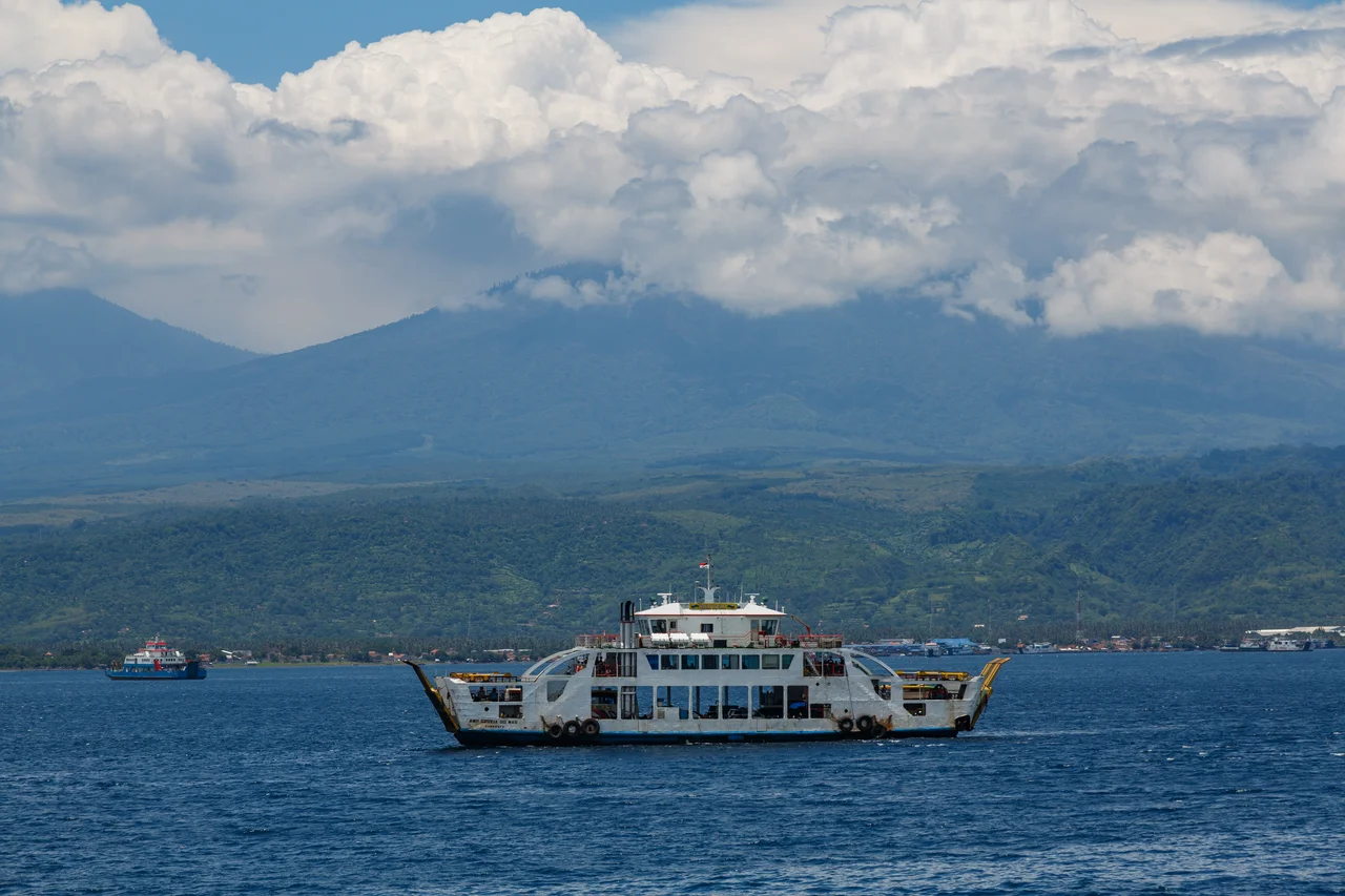
The Ferry and the Bridge That Never Came
No fixed link connects Java to Bali. The only crossing is a ferry running between Ketapang on Java's eastern shore and Gilimanuk in Bali's Jembrana Regency -- a short ride across the strait's narrowest section that nonetheless represents a real boundary. Plans for a bridge have surfaced repeatedly. The Indonesian government has studied the proposal, engineers have drawn designs, and politicians have announced timelines. Each time, the project has stalled. Economic constraints are part of the problem, but local opposition in Bali has been equally significant. For many Balinese, the strait is not merely a navigational inconvenience but a buffer -- a physical separation that slows the pace at which Java's dense population and industrial economy press against Bali's smaller, tourism-dependent one. The ferry, with its limited capacity and weather-dependent schedule, functions as a kind of throttle valve. Whether a bridge would bring prosperity or overwhelm the island remains an open question, and as long as it remains open, the ferries keep running.
Pollution and the Unraveling Ecosystem
At the beginning of the twenty-first century, the Bali Strait's ecological health began to visibly decline. Industrial waste from factories along the Javanese shore entered the water. Fertilizer runoff from agricultural fields upstream reached the coast and fed algal growth. Chemicals used in artisanal gold mining operations leached into waterways that drain into the strait. The cumulative effect has been recorded in degraded fish stocks, damaged coral, and water quality that no longer meets the standards of earlier decades. The strait's strong currents, which once seemed capable of flushing contaminants through quickly, have proven insufficient against the volume of modern pollution. Fishing communities on both sides of the channel have felt the impact directly -- smaller catches, species shifts, and the slow erosion of a livelihood that has sustained coastal families for generations. The Bali Strait remains beautiful from above, its turquoise shallows giving way to deep blue where the seafloor drops. But the water carries more than salt now, and the strait's future depends on choices being made on land.
From the Air
The Bali Strait lies at approximately 8.10S, 114.42E, clearly visible from altitude as the narrow channel separating Java's eastern tip from Bali's western coast. The strait is oriented roughly north-south, connecting the Indian Ocean (south) to the Bali Sea (north). At its narrowest point, the gap is only about 2.4 km -- strikingly thin from the air. Ferry traffic between Ketapang and Gilimanuk is often visible. The volcanic peaks of eastern Java (including Mount Ijen) and western Bali frame the strait dramatically. Nearest airports: Banyuwangi International Airport (WARB/BWX) on the Java side, approximately 15 km west; Ngurah Rai International Airport (WADD/DPS) in southern Bali, approximately 120 km southeast. Tropical maritime weather; best visibility during dry season (April-October).
Nearby Stories
- Bali 8.2 km away
- Java's Little Africa 11 km away
- When the Island Shook 15 km away
- Alas Purwo: Where Java Begins and the Surf Never Stops 28 km away
- Meru Betiri: The Last Forest on Java's Southern Edge 30 km away
- The Ship of Four Names 58 km away
- The Kedopok War: When Probolinggo Rose Against Its Buyer 78 km away
- Shaken Foundations: The 2021 East Java Earthquake 153 km away