Balut Island
Twice a year -- around April 3 and September 8 -- something happens on Balut Island that is impossible anywhere in the temperate world. At noon, shadows disappear entirely. The sun passes directly overhead at this latitude of 5 degrees 24 minutes north, and for a few surreal minutes, every vertical object stands in its own footprint with no shadow at all. It is a small astronomical fact about a small volcanic island off the southern tip of Mindanao, but it captures something essential about Balut: this is a place where the ordinary rules seem slightly different, where the sky puts on shows that most of humanity never gets to see.
A Volcano Sleeping Light
Balut Island rises about 1,800 meters from the seabed, though only the top 862 meters break the surface. At its center sits Mount Balut, a stratovolcano classified by the Philippine Institute of Volcanology and Seismology as potentially active. The volcano is fumarolic on occasion -- steam and sulfurous gases seep from vents on its western and southwestern slopes, where hot springs heat the ground to temperatures near boiling. The Palabuno Hot Spring registers 42 degrees Celsius, warm enough to remind visitors that the mountain is not dead, merely dozing. The rock beneath is predominantly basalt and andesite, the signature materials of the Pacific Ring of Fire. Despite its classification, Mount Balut has no recorded historical eruptions. A massive eruption that darkened Mindanao's skies on January 4, 1641, was once attributed to Balut but later traced to Mount Parker, 80 kilometers to the northwest.
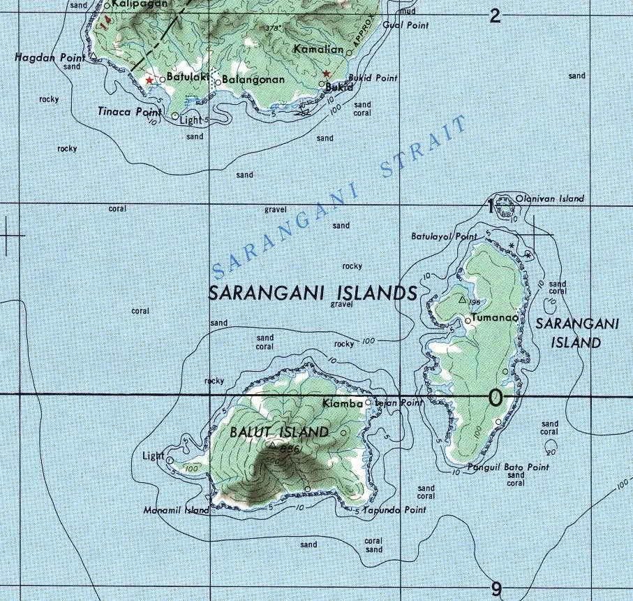
At the Edge of Two Countries
Balut lies just 13 kilometers from mainland Mindanao, separated by the Sarangani Strait, but the island's position makes it a geographic outlier. Together with Sarangani and Olanivan islands, it forms the Sarangani Islands group, administered under the Municipality of Sarangani in Davao Occidental province. Only 65 kilometers to the south lies Marore Island, one of Indonesia's outermost territories. The proximity makes Balut a borderland in the truest sense -- Philippine sovereignty extends to its shores, but Indonesian waters begin not far beyond. Mabila, the town center on Balut's eastern coast south of Lajan Point, serves as both the administrative hub and the main port of entry. The northeast point of the island is low and tangled with mangroves, while the interior climbs steeply toward the volcanic summit. The base diameter of the island is just 8 kilometers, compact enough to walk across in a morning but wild enough to lose yourself in for a week.
Where Both Poles Meet the Sky
Balut's near-equatorial position creates one of the most remarkable stargazing opportunities in the Philippines. On a clear night, you can see Polaris in the north and the Magellanic Clouds in the south -- a combination visible from very few inhabited places on Earth. Polaris hangs just 5 degrees above the northern horizon, about a thumb's width at arm's length. The Southern Cross is visible too, its vertical bar pointing almost directly south. In December 2019, astronomers from PAGASA, the Philippine atmospheric agency, set up telescopes on Balut to observe an annular solar eclipse. Balut, Sarangani, and Olanivan were the only locations in the Philippines where the full annularity -- the sun reduced to a ring of fire around the moon's silhouette -- was visible, with a magnitude of 97.2 percent on Balut. According to local folklore, solar eclipses are caused by the Bakunawa, a celestial dragon that tries to devour the sun. Villagers traditionally respond by making as much noise as possible to frighten the dragon away.
Island Life on the Ring of Fire
Balut is part of the Central Mindanao Arc, a region of frequent earthquakes and volcanic activity that stretches across the southern Philippines. Like most volcanoes in this part of the country, Mount Balut has not been studied extensively by scientists -- a gap that is both understandable, given the island's remoteness, and worrying, given its geological character. The people of Balut live with this uncertainty the way island communities always have: by paying attention to the mountain, the sea, and the sky. The hot springs are a part of daily life, not a curiosity. The ground occasionally trembles. The fishing is good, the volcanic soil is fertile, and the storms that barrel through these waters are weathered with the practiced resilience of people who know their home sits on the edge of something much larger and much older than themselves.
From the Air
Located at approximately 5.40N, 125.39E, Balut Island is visible from altitude as a cone-shaped volcanic island south of the Mindanao mainland, across the Sarangani Strait. No airport on the island; the nearest major airport is General Santos Airport (RPMR/GES). Mount Balut (862m) is the dominant visual feature. Look for the Sarangani Islands group: Balut to the west, Sarangani Island to the east, and tiny Olanivan between them. Recommended viewing altitude: 10,000-15,000 ft for the island profile against the sea.
Nearby Stories
- 1913 Sulawesi-Mindanao Earthquake 21 km away
- Japanese Destroyer Hokaze 189 km away
- 1955 Lanao Earthquake 290 km away
- 2018 Lamitan Bombing 331 km away
- Taluksangay Mosque 378 km away
- Bunaken National Park 382 km away
- Japanese Minelayer Tsugaru 387 km away
- Munakata Taisha 3173 km away