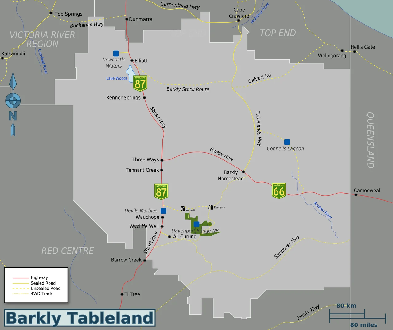

Barkly Tableland
Set the cruise control, point the bonnet at the horizon, and drive. For hours, nothing changes. The Barkly Tableland is a plain of golden Mitchell grass that rolls unbroken to every edge of the sky, an area roughly the size of the United Kingdom inhabited by fewer people than a country town. Out here the word "tableland" is a quiet joke. There is no table, no plateau, no edge to climb. There is only grass, and distance, and the largest silence you may ever stand inside.
The Misnamed Plain
Despite the name, the Barkly is not elevated and has no defined edges. It is a vast treeless expanse dominated by Mitchell grass growing on cracking black clay, and what little water falls mostly drains away into the porous limestone beneath, pooling here and there into shallow lakes and swamps. Roughly it runs from Newcastle Waters in the north to Barrow Creek in the south, threaded by the Stuart Highway. Fewer than 6,500 people live across this immensity, and more than half of them are in a single town. It is one of the most sparsely peopled regions on the planet, the kind of empty that has to be crossed to be believed.
Sixty-Five Thousand Years of Footprints
Long before any highway, this country belonged to its first peoples, and still does. The Warumungu, Warlpiri, Kaytetye, Alyawarr and other language groups have lived across the Barkly and its margins for tens of thousands of years, reading water and season in a landscape that looks featureless only to the untrained eye. Aboriginal cultural sites endure here, among them Karlu Karlu, the Devils Marbles, a jumble of great rounded granite boulders sacred to the traditional owners. The European story is thin and recent by comparison: William Landsborough crossed in 1862 and named the plains for Sir Henry Barkly, Governor of Victoria, and the Overland Telegraph Line of 1872 stitched the first wire of settlement across the Outback.
Cattle Country and the Droving Roads
The Barkly is one of the great cattle landscapes of Australia. Its fertile black soils grow Mitchell grass that fattens beef on a scale few places can match, and the region holds some of the country's largest and most historic stations: Newcastle Waters, Banka Banka, Brunette Downs. The Overlander's Way traces the old droving routes, the paths along which legendary stockmen once walked vast herds east toward the Queensland coast, weeks in the saddle through country that could kill the unprepared. The cattle are still here, scattered across runs so big they are measured in thousands of square kilometres, but the romance of the long drove now lives mostly in the names on the map.
Crossing It Alive
The Barkly is remote, but it is not difficult: two sealed highways, the Stuart and the Barkly, carry an ordinary two-wheel-drive across it in comfort. The trick is respect. Carry extra fuel, water and food, because you can drive for an hour and meet nothing, and the roadhouses are far apart. Stray onto the unsealed tracks and you may not see another soul for days. The old bush rule still holds: if you break down, stay with your vehicle, because a car is far easier to spot from the air than a person. Food runs to roadhouse fare, pies and lamingtons and the inevitable Vegemite, and it is not cheap when every supply is trucked in across the same vast distances you just drove. The reward for caution is the night. With no town light for hundreds of kilometres, the Barkly sky comes down close and blazes, and the Milky Way throws shadows on the grass. Some of the finest camping lies off to the south, in the waterhole country of the Davenport Range and around the Devils Marbles, where the desert wildlife gathers at the few permanent pools. About 140,000 travellers cross the Barkly in a typical year, and most barely slow down, racing through on their way to the Red Centre. The ones who stop, even for a night under that sky, tend to remember it longest.
From the Air
The Barkly Tableland centres roughly on 19.0 degrees south, 138.0 degrees east, straddling the Northern Territory and Queensland border. From the air it is unmistakable: an immense, near-featureless plain of pale gold grass with almost no relief, crossed by the ruler-straight Stuart Highway (north-south) and Barkly Highway (east-west), the surest navigation references for hundreds of kilometres. Tennant Creek (YTNK) anchors the west; Mount Isa (YBMA) and Camooweal (YCMW) sit toward the Queensland side. Cattle stations maintain private gravel strips throughout, including the Barkly Homestead roadhouse. Skies are clearest and the grass most golden in the dry season, May to September.
Nearby Stories
- Riversleigh World Heritage Area 13 km away
- Century Mine 13 km away
- Boodjamulla National Park 54 km away
- Tree of Knowledge, Camooweal 66 km away
- Brunette Downs Station 160 km away
- Mount Cuthbert Township and Smelter 164 km away
- Merlin diamond mine 274 km away
- Tennant Creek 345 km away