.jpg)
Barra (neighborhood)
Stand on Porto da Barra beach at the tip of Salvador and something odd happens. The sun rises over the water to your east. The sun sets over the water to your west. This is because Barra sits at the vertex of a peninsula, with the Atlantic Ocean on the south and All Saints Bay on the west, so the beach looks out on open water in two directions. CNN once named it one of the best urban beaches in the world, alongside Ibiza and Bora Bora. Late afternoons, the beachgoers actually applaud when the sun touches the horizon. This is also the place where, on March 29, 1549, Tomé de Souza landed with a thousand sailors, soldiers, and Jesuit priests and officially founded the city of Salvador - the first capital of Brazil.
Before the City
The story of Barra begins before Salvador existed. In 1501, the Portuguese king placed a marker, a padrão, on the tip of Santo Antônio peninsula to claim the coast for Portugal. The formation became known as Ponta do Padrão. In 1534, Caramuru - Diogo Álvares Correia, the Portuguese castaway who had married the indigenous woman Catarina Paraguaçu and learned Tupi - helped Francisco Pereira Coutinho establish a settlement at what is now Ladeira da Barra. The first Europeans and Indigenous people tried to live together. It went badly. Settler abuses turned the local Tupi hostile, and the settlement was abandoned. In 1549, when Tomé de Souza arrived to found Salvador proper, the abandoned spot became known as Vila Velha - the Old Town. It would remain a suburb of the new capital for the next three centuries.
Brazil's Oldest Fort
The Santo Antônio da Barra Fort is the oldest military construction in Brazil. In 1534, defensive structures of loose stone and adobe went up on the peninsula. In 1598, Governor Francisco de Souza ordered the fort rebuilt in stone and lime mortar. Over the following centuries it was redesigned and renovated multiple times, always under the protection of Saint Anthony, the patron of Salvador. The image of Saint Anthony at the fort was awarded military ranks through the eighteenth and early twentieth centuries, eventually rising to lieutenant-colonel - a saint with pay grade. Dutch forces captured the fort in 1624 and the Portuguese reconquered it that same year. The fort's first wooden lighthouse went up in 1696, running on whale oil and warning ships away from the reef of Santo Antônio. The current iron lighthouse, powered by electricity, replaced it in 1836. Today the fort complex houses the Nautical Museum of Bahia - nautical instruments, shipwreck finds, vessel miniatures, artifacts from the wreck of Galeão Sacramento.
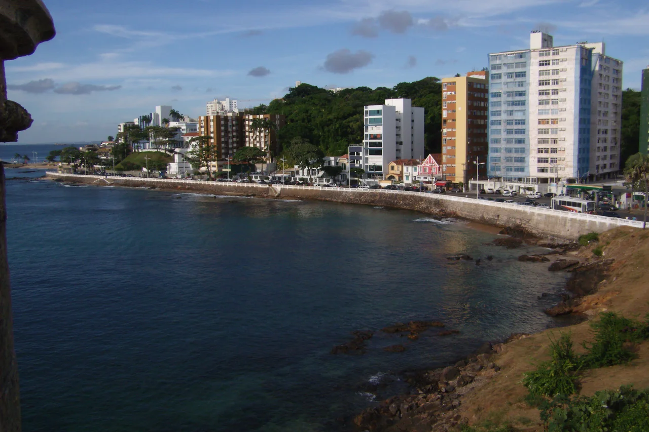
Where Salvador Was Founded
Porto da Barra is one of the few places in Salvador where small boats can land, because most of the city's coastline is protected by reefs. That geography made it the spot of choice for founding the city. Tomé de Souza beached his ships here on March 29, 1549. The landing is officially considered Salvador's foundation day, though construction of the Cidade Alta above the cliffs did not begin for another month. At the northern end of the beach, a 1949 monument commemorates the landing with a marble Maltese cross and a blue-and-white tile mural - originally by Portuguese artist Joaquim Rebucho, restored and reinaugurated in 2013 with a new reading by Eduardo Gomes. The Companhia das Índias Ocidentais (the Dutch West India Company) landed here too, invading Salvador in 1624. The beach has been a threshold for arrival and conflict for nearly five centuries.
The British Diaspora
In the nineteenth century, British immigrants came to Barra in large numbers and shaped its streetscape. They built houses, shipped goods, managed commerce. Being Protestant, they could not be buried in Salvador's Catholic churches, so they established the British Cemetery on the Ladeira da Barra slope. Restored in 2006, it remains one of the most scenic burial grounds in Brazil - a green terrace over All Saints Bay where Britons, Germans, Dutch, and people of other faiths lie buried, a quiet monument to the foreign presence in Bahia. The cemetery's view, the inscriptions in multiple languages, and the pale stones under tropical trees all speak to the cosmopolitan history of a city that was never purely Portuguese. Other nationalities followed - Spaniards built the Spanish Hospital, Portuguese settlers founded the Portuguese Hospital, and waves of Italian, German, Polish, and Russian immigrants arrived in the twentieth century.
Carnival and the New Barra
Today Barra hosts one section of what locals call the largest street Carnival on the planet. The Barra-Ondina Circuit starts at the beginning of Oceanic Avenue near the Farol da Barra lighthouse and runs east to Largo das Gordinhas in Ondina. Trios elétricos - huge trucks stacked with speakers and bands - roll down the avenue playing axé music while crowds dance behind them for days at a stretch. In 2013 Mayor Antônio Carlos Magalhães Neto approved a complete renovation of the neighborhood by the Odebrecht consortium. The 50-million-real reform, completed in 2014, introduced shared-space street design with pedestrian priority, underground lighting, new bus stops, kiosks, ramps for accessibility, and reinforced pavement capable of supporting the heavy Carnival trucks. Barra today is a neighborhood trying to be many things at once - a beach town, a historic district, a Carnival stage, a tourist zone, a residential address for longtime Soteropolitans. From Ponta do Padrão you can still see all of it in one glance: the fort, the lighthouse, the two beaches, the sunset.
From the Air
Located at 13.00°S, 38.53°W at the tip of the Salvador peninsula. Recommended viewing altitude: 1,500-3,000 feet for a clear view of the Farol da Barra lighthouse, Fort Santo Antônio, the horseshoe peninsula, and both beaches. Salvador-Dep. Luís Eduardo Magalhães International Airport (SBSV) is the primary field. Visual landmarks include the white lighthouse tower, the stone fort complex, and the intersection of All Saints Bay to the west with the open Atlantic to the south. The peninsula's geometry is one of the most recognizable coastlines in Brazil.
Nearby Stories
- Recôncavo Baiano 36 km away
- Battle of 4 May 46 km away
- MV Araraquara 102 km away
- Pé de Serra 112 km away
- Serra do Conduru State Park 146 km away
- SS Annibal Benévolo 153 km away
- Ilhéus 208 km away
- SS Principessa Mafalda 418 km away