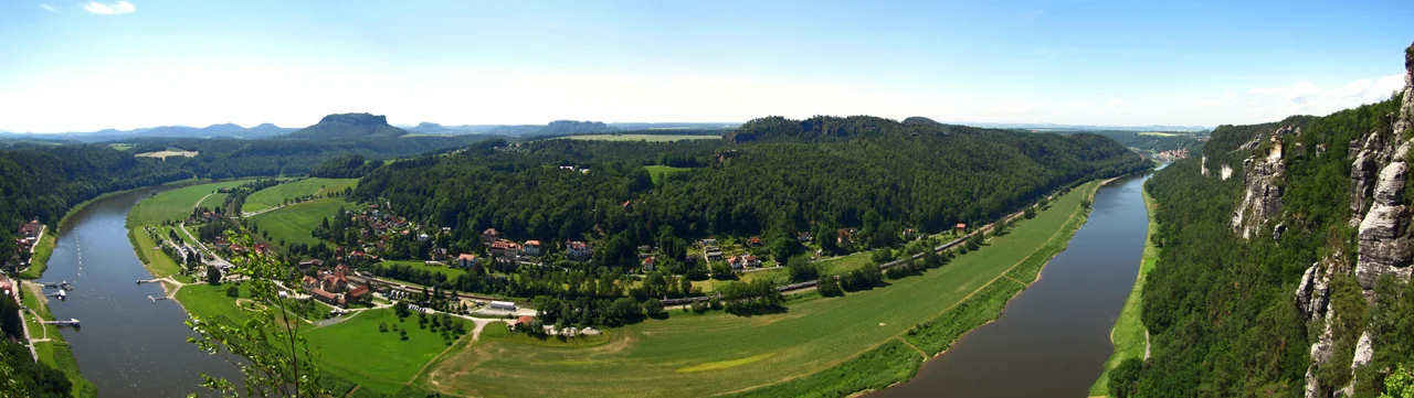

Bastei
At Pentecost in 1812, a butcher from Lohmen named Pietzsch hauled bread, butter, beer, brandy, coffee and milk up onto a shelf of sandstone above the Elbe and started selling to walkers. There was no bridge yet, no inn, no railing along the drop. Two huts, a view, and a man who understood that people would pay to be somewhere astonishing. Within four years his huts had burned down and he had rebuilt; within fifteen years the Bastei had a proper inn, and within forty it had the stone bridge that put it on postcards for the next two centuries. The commerce arrived before the infrastructure, which is a fair summary of how Saxon Switzerland was made.
A Bastion Without a Fort
Bastei means bastion, and the name is literal. These pinnacles were folded into the old defensive ring around Neurathen Castle, a stronghold carved directly into the rock rather than built on top of it. The first written trace comes from 1592, when the surveyor Matthias Oeder recorded the place as Pastey during the Electorate of Saxony's first state survey. What he was mapping was the work of water: the Elbe and its tributaries cutting down through a thick bed of sandstone over more than a million years, leaving towers and fins standing where the softer rock washed away. The result rises 194 metres above the river and reaches 305 metres above sea level, a wall of pale stone split into columns with pines growing improbably out of the gaps.
The Painters Got There First
Long before the coach road, artists walked in from Wehlen and Lohmen along a route that came to be called the Malerweg, the Painter's Path. Caspar David Friedrich worked the Bastei into his Felsenpartie im Elbsandsteingebirge; Ludwig Richter sketched here too. Travel literature caught up in 1798, when Christian August Gottlob Eberhard published a description of the lookout, and by 1801 one of the first professional walking guides, Carl Heinrich Nicolai, was writing in the register of the overwhelmed: "What depth of feeling it pours into the soul! You can stand here for a long time without being finished with it." Reaching it from Rathen stayed hard until 1814, when a staircase of 487 steps was cut up out of the Wehlgrund valley. Five years later August von Goethe came through and reported that the coffee, double beer and fresh bread and butter "really revived the tired wanderer."
Seven Arches Over Forty Metres
The first Bastei Bridge was wooden, thrown across the clefts of the Mardertelle in the 1820s to link the outer rock shelf with the Steinschleuder and the Neurathener Felsentor. Visitor numbers made it obsolete. In 1851 it was replaced by the sandstone bridge still standing today: 76.5 metres long, seven arches, spanning a ravine forty metres deep, built of the same rock it crosses so that from below it looks less constructed than grown. Cross it and you reach Neurathen Castle, the largest rock castle in Saxon Switzerland, where a self-guided circuit passes chambers hollowed out of the stone, timber rebates, a cistern, and stone shot left from a medieval siege engine. In 1853 the Saxon court photographer Hermann Krone set up on this bridge and made what are counted as the first landscape photographs taken in Germany.
The Railway That Was Never Built
Success brought plans. An inn with beds went up in 1826 to designs by Gottlob Friedrich Thormeyer, was rebuilt and extended in 1893 and 1894, got a high-pressure water main in 1895 and a telephone line in 1897. Around 1900, promoters proposed a mountain railway climbing from the Elbe valley to the rocks. Conservationists, already arguing that the landscape needed protecting from its own popularity, killed it. The railway left nothing behind but a name: a ravine southwest of the Bastei is still called the Eisenbahngründel, the Little Railway Valley. In 1938 the Bastei became the first nature reserve in the Elbe Sandstone Mountains, and it now sits inside the strictly protected core zone of Saxon Switzerland National Park. The rock keeps its own schedule regardless. In 2000 a large piece of the nearby Wartturm simply broke off.
Arriving the Old Way
The classic approach is still by water. Paddle steamers run up the Elbe from Dresden to the spa village of Rathen, and the climb from there passes an open-air museum of early Slavic settlement and the turning for the Rathen Open Air Stage, a theatre set among the rocks. From the Ferdinandstein, a spur off the main path, you get the photograph everyone knows: the bridge in profile, arches stacked against the drop. Königstein Fortress crowns a table mountain a short distance upriver, and the long-distance Eisenach to Budapest path runs straight over the Bastei on its way southeast into Bohemian Switzerland across the Czech border. Of all the viewpoints in Saxon Switzerland, this one still draws the most people, which Pietzsch would have found entirely reasonable.
From the Air
The Bastei stands at 50.97 N, 14.07 E, on the right bank of the Elbe about 13 nm southeast of Dresden and 5 nm east of Pirna. The formation tops out at 305 metres above sea level, 194 metres above the river. Best viewed between 1,500 and 3,000 feet AGL, following the Elbe upstream from Dresden: the river makes a tight loop at Rathen and the pale sandstone towers stand clear of the forest on the north bank, with the seven-arch bridge visible as a thin line between pinnacles. The flat-topped Lilienstein, Königstein and Pfaffenstein table mountains lie a few miles upriver and make unmistakable navigation marks. Nearest airport is Dresden (EDDC), about 15 nm northwest; Ústí nad Labem (LKUL) lies roughly 16 nm south across the Czech border. Morning valley fog along the Elbe is frequent and can hide the gorge while leaving the tops in sun.
Nearby Stories
- Moritzburg Castle 2.8 km away
- Zittau 3 km away
- Bautzen 13 km away
- Upper Market Square (Görlitz) 16 km away
- Kaditz Lime Tree 22 km away
- The Defenestration of Prague: The Thrown Men Who Started a Thirty Years' War 61 km away
- The Anschluss: When Austria Vanished Overnight 279 km away
- The Battle of Vienna: The Cavalry Charge That Saved a Continent 289 km away