Battle of Chaeronea (86 BC)
Roman legionaries reached down with their bare hands and grabbed the long pikes of the Pontic phalanx, wrenching them sideways out of position. They had been told they would be fighting slaves - the lowest insult Roman propaganda could find for the men Mithridates VI had armed and sent west - and according to Plutarch their fury at the indignity was what carried them through the press. They were 17,000 men, possibly fewer. The army facing them was at least three times that number, perhaps more, occupying the same plain where Philip of Macedon had broken the Greek world 252 years earlier.
Mithridates' War
Mithridates VI of Pontus had spent a decade preparing the war Rome did not see coming. In 88 BC his agents organized the simultaneous massacre of perhaps 80,000 Romans and Italians living across Asia Minor in a single day - the Asiatic Vespers, an act of cold political violence that committed Pontus to total war. Athens, Greece, and a host of smaller cities switched sides to Mithridates, hoping to break free of Rome forever. The Senate sent Lucius Cornelius Sulla, a brutal political climber who had just marched on Rome itself with his own legions to win the command. Sulla besieged Athens through the winter of 87 BC, took it in March 86 with a slaughter that filled the Agora with blood, and pushed north into Boeotia in pursuit of Mithridates' general Archelaus and his vast Pontic army.
The Plain Again
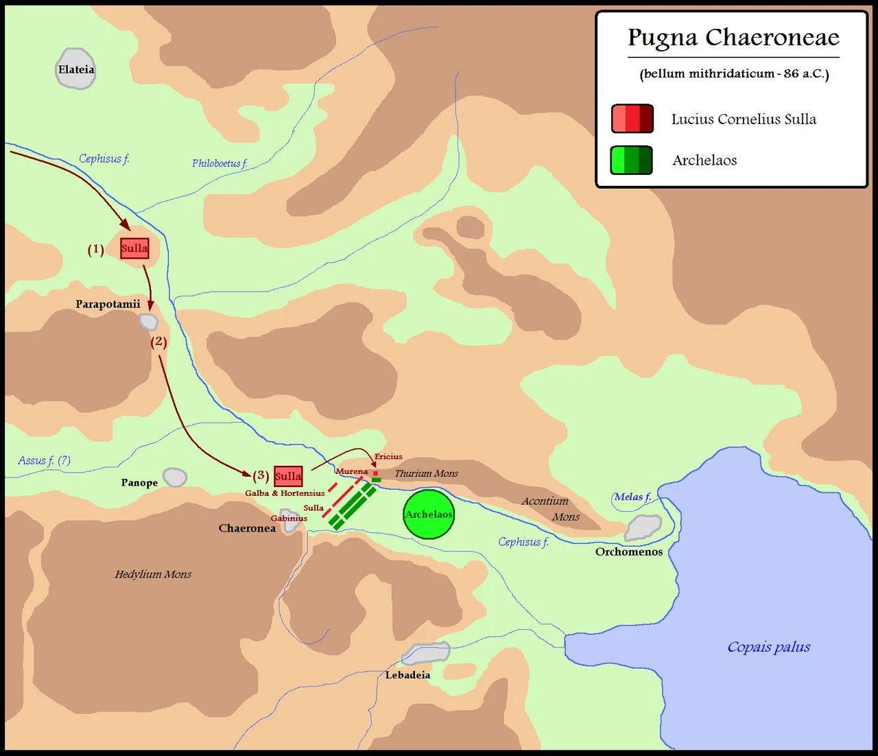
Archelaus drew up on the broad plain west of Chaeronea with troops drawn from across Mithridates' empire: Macedonian-style phalanxes, Pontic missile units, Cappadocian and Galatian cavalry, and the corps of scythed chariots that were supposed to terrify the legionaries into breaking. Sulla seized the high ground first, occupying the hill of Parapotamii and stationing his legate Gabinius with a full legion inside the town of Chaeronea itself. He had locals from Chaeronea guide his lieutenant Murena to attack the Pontic right flank from above, where the slope did half the killing for him. Around 3,000 Pontic soldiers died on that flank alone. Then the chariots came - and Sulla's veterans had built a forest of stakes in their path. The chariots impaled themselves on the stakes, the horses screamed and crashed, and the survivors turned and ran back through their own lines.
Hand to Hand
The Pontic phalanx came on with sarissas - eighteen-foot pikes designed to keep an enemy at unreachable distance. Roman gladii were two feet long. The legionaries closed the gap anyway, crouched under the points, and worked their way into the phalanx with shields and short blades. Some, Plutarch wrote, simply seized the pike shafts and tore them from their owners' hands. Archelaus tried to outflank Murena on the Roman left, and very nearly succeeded - the Roman tribune Hortensius found himself cut off and surrounded - until Sulla raced across the field with his cavalry and broke the Pontic charge. The fighting lasted hours. By the end, the Pontic line collapsed and ran for the Cephissus river. Romans hunted the fugitives across the plain and into the marshes. The exact number of dead is impossible to verify, but Sulla claimed only fourteen of his men were lost, while tens of thousands of Mithridates' soldiers - many of them conscripts, enslaved soldiers, and Asian Greeks who had been promised this would be their war of liberation - did not see another sunset.
The Trophies of Sulla
Sulla raised two stone trophies on the field, one on a hill called Thurium where the locals had guided Murena's flank attack. Archaeologists rediscovered fragments of it on Isoma Hill in 1990 - a square base of grey-white marble that once held an unfluted column topped with carved armor. Plutarch, who came from Chaeronea and grew up walking these fields, wrote that the trophy was inscribed with the names of three gods: Ares, Nike, and Aphrodite. War, victory, and love. Sulla had a peculiar attachment to Venus and called himself her favored son. His coins after the battle showed two trophies flanking a religious vessel - those same trophies, almost certainly. Mithridates was not finished. He would lose again at Orchomenus that summer, sue for peace, and live to fight two more wars before dying by suicide in the Crimea three decades later. Sulla returned to Rome and made himself dictator. The plain at Chaeronea kept being a plain.
From the Air
The 86 BC battlefield occupies the same plain west of Chaeronea (modern Chaironeia) in Boeotia, central Greece, at approximately 38.50N, 22.86E - just slightly north of the 338 BC battle site. Mount Thurion (Isoma Hill) marks one trophy location. Recommended viewing altitude 3,500-5,000 ft AGL. Nearest airports are Athens International (LGAV) 60 nm southeast and Tanagra (LGTG) 35 nm east. From altitude the Cephissus valley reads as a long flat agricultural corridor running northwest-southeast between limestone ranges, with Mount Helicon visible to the south and Mount Parnassus dominating the western horizon.
Nearby Stories
- Battle of Alamana 3.6 km away
- Free and Real 5.7 km away
- Agios Thomas Tanagras 5.7 km away
- Pythian Games 11 km away
- Thespiae 12 km away
- Euripus Strait 14 km away
- French Cruiser Châteaurenault (1898) 17 km away
- Skopelos 32 km away